Best of the Best Projects 2018
Project of the Year, Best Highway/Bridge: US 34 Permanent Repairs Project
Nearly all of the bridges in the canyon were damaged or destroyed, so they were rebuilt higher above the river and armored with rocks.
PHOTO COURTESY OF KIEWIT
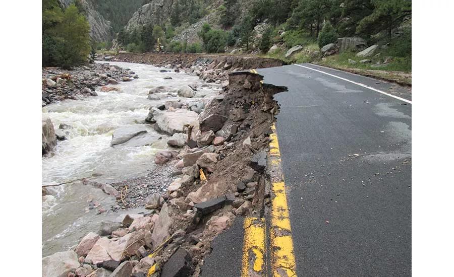
Large expanses of highway were wiped out in the 2013 flood.
PHOTO COURTESY OF KIEWIT

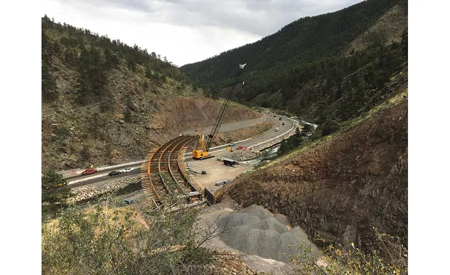
Crews sculpted the canyon walls to improve safety.
PHOTO COURTESY OF KIEWIT
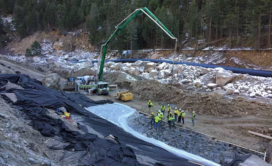
Soil-cement mixing created new bedrock.
PHOTO COURTESY OF KIEWIT
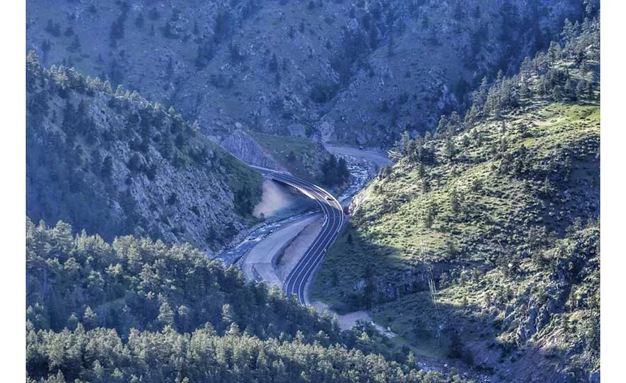
The completed project allows the river and roadway to work more in harmony.
PHOTO COURTESY OF KIEWIT
Owner Colorado Dept. of Transportation (CDOT)
Lead Design Firm Jacobs Engineering
General Contractor Kiewit Infrastructure Co.
Consultants Ayres Associates; Muller Engineering; RockSol Consulting Group Inc.; WSP; Yeh and Associates Inc.
Mary Myers doesn’t have an average commute to work, but it’s better than it used to be. Myers lives halfway up Big Thompson Canyon west of Loveland, Colo., in a cabin purchased by her grandmother in the 1940s. She drives a winding two-lane road seven miles into town. It’s just 20 minutes on a good day, but the commute became impossible after a September 2013 flood erased most of U.S. Highway 34 through the canyon, along with several key bridges.
A series of storms, described as a 1,000-year-rain event, dumped more than 21 in. of water in a few days across northern Colorado, killing eight people, forcing thousands from their homes and causing an estimated $2.9 billion in damage.
Emergency responders could not reach trapped residents after the flood. Myers, like many of the canyon’s 800 residents, had to be evacuated by Black Hawk helicopter in the country’s largest emergency airlift since Hurricane Katrina.
Fourteen counties were declared disaster areas. The Big Thompson River surged 4.5 ft above flood stage, damaging 23 miles of U.S. 34 through the canyon and wiping out 12 miles of roadway altogether.
Larimer County Sheriff Justin Smith said afterward: “The road’s just not there. It was washed to bedrock.”
U.S. 34 is a critical artery connecting Loveland and the busy Interstate 25 corridor with the town of Estes Park and Rocky Mountain National Park, the state’s most popular tourist attraction, which averages 3 million visitors a year. The road carries more than 700 vehicles an hour through the canyon on summer weekends.
Looking for quick answers on construction and engineering topics?
Try Ask ENR, our new smart AI search tool.
Ask ENR →
For Myers, the damage hit even closer to home. “The flood took 50,000 cubic yards of dirt from our neighborhood, and the river cut a cliff in our front yard, just feet from our home,” she says.
Kiewit Infrastructure Co. completed emergency repairs on U.S. 34 in just 59 days in 2013 and then tackled permanent repairs in a $280-million project that started design in fall 2015 and construction the following October. Kiewit finished the work in May 2018, under budget and two years ahead of schedule.
The team’s mandate from the Colorado governor was to build the road back better than it was before. “But you can’t flood-proof an entire canyon,” says Doug Stremel, design project manager for Jacobs, the lead design firm. “We had to evaluate the river and the roadway as one system. They must coexist. It’s a river with a road problem as much as the other way around.”
The project, performed under a construction manager-general contractor delivery for owner Colorado Dept. of Transportation, fostered innovation and broad collaboration through all four of its construction packages. The team credits the CM-GC delivery for enhancing communication with the project’s more than 25 stakeholders, including multiple counties and towns, the Bureau of Reclamation, U.S. Forest Service and Colorado Parks and Wildlife, among many others.
“In a traditional low-bid contract, everyone works in silos … there’s a lot of boundaries,” said Will White, Kiewit’s executive project director, via email. “CM-GC tears down those silos … and provides the lowest cost with the most efficient schedule for stakeholders.”
Jason Hagerty, project manager for Kiewit, agrees. “It kept things open and transparent, from day one,” he says.
“It also helped us mitigate the impact of work on canyon residents and allowed us to proceed more efficiently,” says Steven Humphrey, assistant project director with owner’s representative Muller Engineering. “It was the only possible delivery method to meet our project goals.”
The CM-GC approach gave stakeholders a better sense of what the project could and couldn’t do. The canyon extends for 26 miles, but the funding agreement covered damage on only 15 of those. “It helped us prioritize damaged areas and define limits for the work,” Hagerty says.
The primary goal was to improve canyon ingress and egress after future floods, especially for first responders. “We’re confident after this project that the next major flood event will impact only one mile, not 12 miles, of the canyon,” says James Usher, project director for CDOT. “To do that, we had to look at the road and the river as one system, make sure they worked together, and CM-GC was the only way to achieve that,” he says. “We considered design-build first, but that would have blown the engineering bids out of the water. Having an experienced contractor at the table during design was key.”
The team’s holistic thinking drove several innovations, among them convening a “challenge team,” a small group of senior engineers and contractor executives not assigned to the project who brainstormed new approaches. One of those: implement a technique called soil-cement mixing, new to CDOT, to stabilize the fragile roadway that lacked natural bedrock in some sections. Crews drilled deep beneath the road to retrieve natural bedrock material, then mixed it with concrete to create a 15-ft-wide section of man-made bedrock so the river can’t easily erode the road base from below.
That technique involved intense coordination and strategic transport of 1.8 million cu yd of material, Hagerty says. All riprap and other material generated from rock cuts and blasting—nearly 814,000 tons, including 380,000 cu yd of drill-and-shoot rock excavation—was crushed, processed and placed on-site. Despite the inherent dangers of extensive excavation and working round the clock in extreme weather conditions in a tight canyon, the project had zero OSHA recordables in more than 400,000 Kiewit hours worked and 265,689 subcontractor hours worked.
Other innovations included cutting into the canyon’s steep rock faces where possible to move the roadway farther away from the river, armoring the bridge approaches with rocks, installing grouted riprap beneath the surface along a two-mile stretch of roadway to create a more solid foundation, and widening and in some cases rerouting the river to help protect the roadway.
“We swapped the road and river in places like the horseshoe bend to give the river more room,” Stremel says. The new bridges elevated the roadway farther above the river. In total, crews restored 8.6 miles of the river and expanded the flood plain wherever possible.
Other key challenges included water and traffic control. “We used 42-in. pipes in about a half-dozen areas to divert the river around us,” Hagerty says. “Where we had room, we built diversion dams.” Tasks were phased so that work in the riverbed took place during low flows, when the river ran 50 to 350 cfs, compared to its seasonal high of nearly 1,400 cfs, he says.
There is no cellphone service in the canyon, so traffic coordination was done using radios. The project included two eight-month full closures of U.S. 34, which Hagerty says were key to accelerating the schedule. Because nearly 500 people live within the closure zones, resident traffic was managed using morning and evening pilot-car hours and a resident scheduling service.
That’s when Myers’ seven-mile commute often became an 85-mile detour. “I burned out a clutch in my truck following pilot cars for two years,” says Myers, who was part of the volunteer community canyon restoration team. “But I have observed this project from end to end and have seen the layers of resiliency installed along the banks and roadside. I have a much greater confidence level for how the canyon will handle a similar (flood) event.”
White adds: “It was a true partnership felt by everyone, including the community. There will be more success stories like U.S. 34 as public owners embrace the use of alternative contract models.”

")
 PEDESTRIAN BRIDGE")
