Machine Vision System Spots Roadways in Need of Repair
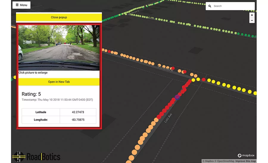
Roadbotics’ machine vision system has been trained to rate the condition of roads by a simple color-coded system based solely on windshield-camera footage recorded while driving.
IMAGE COURTESY OF ROADBOTICS
For cities and municipalities, surveying roads that require repair and resurfacing can be tedious, time-consuming work. But a Pittsburgh-based startup is trying to automate some of that process, using intelligent systems to speed up data collection so capital spending decisions can be made more efficiently.
Founded in 2016, Roadbotics is based on a machine vision technology developed at Carnegie Mellon University. Using footage collected from windshield-mounted cameras on cars driving through a road network, the computer vision algorithm has been trained to recognize flaws in road surfaces, including cracks, potholes and spalling. Geotagged road locations are rated on a five-color scale, and the data is collected into a map file that can be loaded into popular GIS imaging software.
“Normally this is a time-consuming and costly process,” says Ben Schmidt, Roadbotics CTO. “Here, we snap our fingers and there’s a comprehensive view of your road network.”
One of Roadbotics’ first customers was Ryan Fonzi, associate planning director for North Huntingdon Township, Pa., who needed a faster way to track the 160 miles of road under his supervision. “Their data was important for us—we can pull up conditions in certain wards. We have an unbalanced situation here where some wards are in better or worse shape, but now we can look at it township-wide,” he explains. “We have the data to help us make smarter decisions.”
Before Roadbotics, Fonzi had to send out a pair of township employees in a town vehicle with a clipboard to record road conditions in need of repair. These paper records were then manually entered into a GIS mapping system of the road network. The process took between four and five months, and could only be performed every few years. With Roadbotics, it took an intern a week or two to drive the township’s roads with a camera mounted on the windshield, and then a few more weeks for Roadbotics to process the data. “The real benefit to us is the Shapefile that Roadbotics delivers,” says Fonzi. “With that we can load it directly into our GIS and start making planning decisions right away.”
Feedback from early customers such as North Huntingdon also helped the product evolve. “Our first product version just showed point data,” says Schmidt. But Fonzi and his team couldn’t make the case for capital funding point-by-point along a roadway. “So we did a version of the software that calculates ratings for entire road segments and overlays it over the map as an option,” explains Schmidt.
The added benefit of having video and still images of road conditions that can be called up at will was also useful in haggling with public officials over funding for roadwork, says Michael Turley, assistant township manager for North Huntingdon. “When dealing with a governing body we can show something that isn’t just a matter of a human opinion. Before, it was us going out and saying to them what the condition was, but this is just what the camera sees. We can pull this up at public meetings and settle debates there.”
Looking for quick answers on construction and engineering topics?
Try Ask ENR, our new smart AI search tool.
Ask ENR →
Roadbotics has been improving its technology since it first began trials almost two years ago, and Schmidt says affordable road surveys could change how cities and municipalities plan their capital budgets. It is currently working with North Huntingdon and other early adopters to schedule scans of their road networks every one or two years, creating a visual timeline that can better inform longer-term capital planning.
“We’re look at things that can radically change how pavement is monitored and maintained going forward,” says Schmidt. “Our customers are already seeing how this could change the way things are done systemically in the future.”


