Technology | Reality Capture
Brasfield & Gorrie Drone Fleet Sends Data Directly to ArcGIS
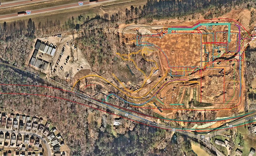
A Brasfield & Gorrie digital dig board, regularly updated with the latest utility data from the site.
Map imagery courtesy of Brasfield & Gorrie
Contractor Brasfield & Gorrie is working to update its site maps to avoid utility strikes and other incidents by integrating drone flight data directly into their GIS maps using Esri’s Site Scan for ArcGIS Pro.
The firm has been using drones for mapping and construction progress photos since 2017. Their program began with six drones, and by 2023 it had grown to 38, with more than 60 FAA-certified drone pilots on staff. With around 200 active jobsites and more projects in the bidding process at any given time, drone mapping has proven invaluable for site intelligence.
“Around 2018, we started investigating [the case for] drones giving us an updated map of the site,” says Ryan Hittie Sr., innovation and operational technology specialist at Brasfield & Gorrie. “Utility strikes happen across the industry, and we wanted to reduce that with the drone data that we had. So we started overlaying lines on the drone map, just coloring them in.”
After experimenting, Brasfield and Gorrie integrated their drone data into their Esri ArcGIS mapping platform.
Using Site Scan for ArcGIS alongside ArcGIS Pro, ArcGIS Field Maps, and ArcGIS Online, the firm is able to track and manage sites by updating their maps with drone scan data. All of the ArcGIS Pro maps are updated with the latest scans, and field personnel can pull up the latest maps on their phones. This has led to a decrease in utility strikes during construction and has helped workers with tasks like verifying that rebar is in place for concrete placements. Owners can track projects as they’re built using 3D meshes generated from Brasfield & Gorrie’s own imagery processing tools.
“We use ArcGIS Online to basically make it more accessible from someone’s phone,” says Kyle Duncan, another innovation and operational technology specialist at Brasfield & Gorrie. “We literally stitched the drone image on top of the map to where we can actually locate someone via their GPS on their phone.”
Anyone on a Brasfield & Gorrie site can localize themselves in ArcGIS Pro to see the subsurface conditions around them. It is nearing the point where as soon as a drone is done flying, imagery is uploaded and maps are updated in the ArcGIS Online project. Duncan says this could be done every day, week or by milestone, depending on a project’s needs.
Looking for quick answers on construction and engineering topics?
Try Ask ENR, our new smart AI search tool.
Ask ENR →

Brasfield & Gorrie uses drones to take photos, videos and LiDAR scans.
Photo courtesy of Brasfield & Gorrie
A LiDAR payload on a drone can scan through existing buildings or vegetation to generate a topographical image of ground conditions, which can be loaded into Civil 3D or another civil engineering software suite, Hittie says.
Having LiDAR, drone imagery, utility maps and 3D meshes all together in one platform has proven valuable for the firm. “The industry had all of these technologies operated in a silo,” says Russ Gibbs, Brasfield & Gorrie vice president and director of virtual design and construction. “Drones were in a silo, big boards were in their own silo, and GPS and laser scanning [were in another silo].”
Gibbs says having data move between silos is what was needed. “We’re starting to see products pulling all of it together into one platform. All of them are finally starting to cross and you can see that to build the project, they all have to work together. Having the ability to get the information to the end user in more simple platforms is the name of the game.”
For the latest developments in reality capture, mapping and data management, be sure to attend ENR FutureTech, held June 3-5 in San Diego. Visit www.enr.com/future-tech for more information.


