Public Agencies Test Digital Twin Tool for Improved Asset Monitoring
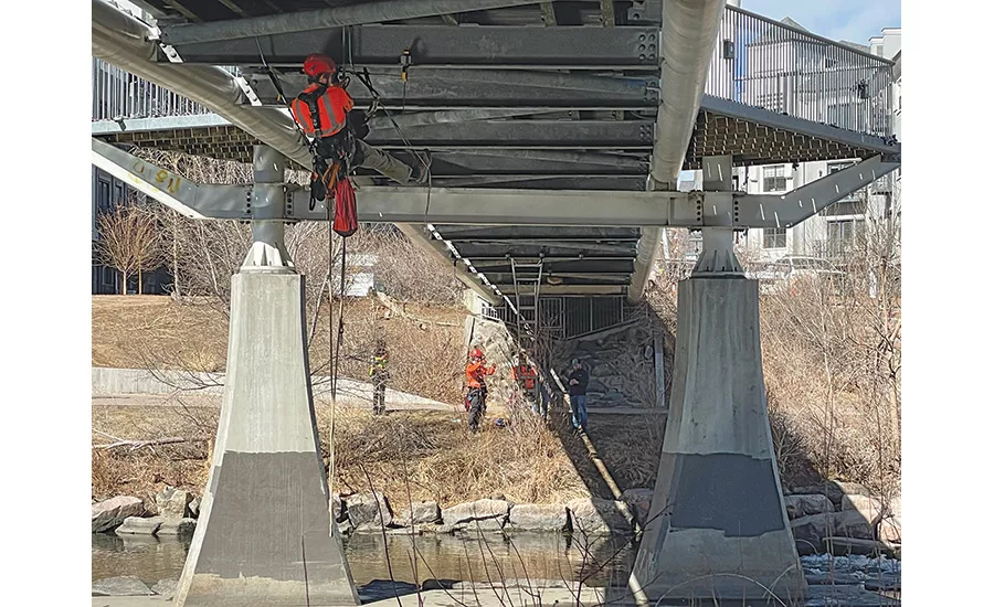
Denver bridge is monitored by sensors, drones, and other tools integrated into a digital twin.
Photo Courtesy of Stantec
Public agencies are testing a tool that could take monitoring of bridges and dams to a higher level by using data from drones and sensors in a digital twin. Bentley’s iTwin Applications for Situational Intelligence aims to provide operational insights, improve decision-making and augment inspection processes by using reality meshes.
Dustin Parkman, Bentley vice president of transportation, says that the collapse of a casino in New Orleans several years ago prompted him to “start thinking about these types of solutions.” Gregg Herrin, vice president of water infrastructure, adds that his Vermont hometown has had bridges wash away in recent flood events, with reservoirs nearly overtopped. “We’re bringing together a few technologies that relate to being able to capture and display realities.”
The tool evolved out of Bentley’s acquisition of sensemetrics Inc. and Vista Data Vision two years ago, adding their IoT and monitoring capabilities to the iTwin platform for infrastructure. “We can take the GIS data and look at things from a bird’s eye view, then zoom into each of those bridges—from a 2D GIS world to a 3D detailed world,” says Parkman. “It allows agencies to understand risks at a more macro level, then zoom into a micro level of detail where you can determine if there is a risk. You can quickly put that sensor data in context of the structure itself, without having to send someone onto the site.”
So if a bridge has cracks, “we apply what we call AI detectors that will look at the [data] to stitch together a combination of risk factors and identify where an inspector should focus their time,” he says.
The city of Denver agreed to let Stantec monitor a pedestrian cable-stayed bridge over the Platte River using the tool. “It’s a unique bridge—cable-stayed with columns arching away from the bridge,” says John Barone, infrastructure technology lead with Stantec. “We’re still in the process of getting data.”
The Stantec team uses drone footage to create a reality capture of the bridge, along with an array of sensors to capture real-time conditions, combining the existing conditions model with the bridge design model. “You can click on a pier and see photos from its last inspection, [pier] data, maintenance schedules,” says Barone. “We set up a dashboard to monitor those sensors, and any time there is a reading outside the tolerance we set, we get a notification.”
The tool is also being used to monitor the New Bullards Bar Dam in Yuba County, Calif., a 645-ft-tall concrete arch dam that is the fifth-tallest in the United States. “We chose the tool because of the sheer size of the dam, and we needed to update our monitoring instruments,” says Tim Truong, chief dam safety engineer with Yuba Water. “We are now able to immediately track the deformation response of the dam to both reservoir elevation and temperature. We have a monitoring tool to quickly evaluate the dam after major events, like an earthquake.”
Looking for quick answers on construction and engineering topics?
Try Ask ENR, our new smart AI search tool.
Ask ENR →
Barritt Lovelace, vice president of UAS, AI and Reality Modeling with Collins Engineers, says his firm’s use of this kind of technology has accelerated in the last couple of years. “The biggest thing is being able to share the model more easily online with asset owners with the iTwin experience.” Working with many state transportation departments, “we’ve been able to demonstrate a 30% cost savings—a lot is from reduced time in the field, less need for lane closures and access vehicles. We can also deliver much higher quality product and more data.”
The tool can be applied to pavement, tunnels, retaining walls and other infrastructure, adds Parkman. “One of the things we worry about is adjacent construction’s impact to rail networks; we’re exploring that now,” he says.
Barone anticipates using digital twins to improve monitoring of sensors, drainage flows, utilities, slope stabilization and more. “We hope to add in other sorts of data—asset maintenance data, rights of way and ownership, GIS data—all into a single platform.”


