Army Corps Uses ArcGIS Story Maps for COVID-Era Public Outreach
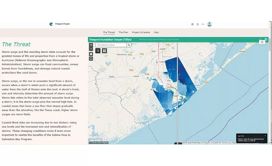
Visit www.swg.usace.army.mil/S2G to interact with these maps on the district’s website.
Image courtesy USACE Galveston District
Two years ago, the U.S. Army Corps of Engineers Galveston District was already using Story Maps to communicate the scope of its $4-billion Coastal Storm Risk Management efforts in Port Arthur, Freeport and Orange County, Texas. The CSRM Program is intended to reduce the risk of storm surge impacts along the Texas coast. The effort includes flood risk reduction, coastal storm risk reduction, floodwalls, levees and gates. ArcGIS Story Maps stitch together maps, illustrations, narrative text and other multimedia content into a web-based, interactive layout.
When the COVID-19 pandemic hit in March 2020, Story Maps became the de-facto tool for communicating project information to local communities that could no longer attend public meetings.
“When you’re on the Galveston district website and you launch the Sabine to Galveston Bay program [within the CSRM], you automatically go to a Story Map that shows the studies and projects,” says Kelly Burks-Copes, project manager of the USACE’s Coastal Texas study set to be the follow-up to CSRM. “Port Arthur has already broken ground and Freeport will come along shortly and then Orange County.”
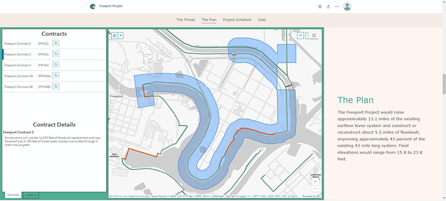
All three projects are organized by contract as well as their timelines, from study to groundbreaking to completion. Project managers have been able to use the Story Maps’ slide-view function in online public meeting presentations.
Because the Galveston District already was using ArcGIS Online, much of the mapping data to create the time-lapse visuals, before-and-after shots and interactive maps of Galveston Bay already existed. Using that data to build out a more comprehensive set of Story Maps for outreach required a bit more work in ArcGIS Online by Michael Prymula, enterprise geospatial systems engineer for the USACE based in New Orleans, and the GIS team. “We take some BIM data, but it’s more along the lines of MicroStation files or CAD drawings built by the engineers,” Prymula says. “We’ll bring that in and convert those over to a GIS format, a shape file or a feature class. We end up storing all of this data in ArcGIS Online.”
Visit www.swg.usace.army.mil/S2G to interact with these maps on the district’s website.
Image courtesy USACE Galveston District
Having all the data in ArcGIS helps maintain it as an authoritative source of truth, even as the district layers in drone flight captures and other content. “We don’t have 10 different versions of it on everybody’s computer. It’s in one central location,” Prymula said.
Now that work on CSRM is well underway, the district has completed its study for Coastal Texas—a program estimated to cost $29 billion—which is now being reviewed by Congress as part of the latest Water Resources Development Act.
Looking for quick answers on construction and engineering topics?
Try Ask ENR, our new smart AI search tool.
Ask ENR →
Despite the lifting of COVID-related meeting restrictions, the Galveston District says it’ll continue using Story Maps. “We’re planning for it, we’re budgeting for it and we’re actually innovating so that we can use Story Maps quarterly to reach out to the public,” Burks-Copes says. The district is also helping other Corps districts use Story Maps for outreach.
“We’ve got some large-scale projects, so there is funding in our budget to allow for this type of engagement,” says Michael Braden, chief of the USACE Mega Projects Division. “That’s a real challenge [with smaller projects]: To make sure you’ve got funding, you can afford it as an indirect expense—I’ll call it discretionary expense—but in today’s day and age, it’s really mandatory to engage our stakeholders and communicate status.”


