EDUCATION
Fundamentals of Surveying: Land Surveying, GIS and Geomatics
As the land surveying profession evolves to meet the changing needs of a high-tech world, advances in data collection and computing power support increasing demand for comprehensive geographic information. In addition to measuring distances and defining boundary lines, multiple geospatial disciplines are used today to map above ground and underground, inside and outside, in two and three dimensions.
The use of photogrammetry, remote sensing, LiDAR, GPS/GNSS, robotic total stations and other technology offer new opportunities for land surveyors to gather highly precise and accurate spatial data. Complex relational geodatabases called geographic information systems (GIS) then integrate, manage and analyze this large volume of data to serve many applications.
As geospatial technology continues to develop, the terminology used in the industry is struggling to keep up. Traditionally, land surveying refers to using applied mathematics to measure relative vertical and horizontal positions to map the earth’s surface and to mark boundaries; however, the methods used today to measure and collect geographic data have moved far beyond the original Gunter’s chain and surveyor’s compass.
With the introduction of new tools, the lines between engineering, land surveying, and GIS sometimes overlap and a broader geospatial definition is the new norm. To better represent the range of knowledge in use today, the term geomatics, or geomatics engineering, is used to refer to multiple technology disciplines in use by surveyors, while GIS refer specifically to the hardware, software and databases that store layers of geographic data and make them accessible to users.
Lines Blur Between Geospatial Disciplines
Confusion regarding the differences between various geospatial disciplines is not new, but it is getting worse as more kinds of technology are added to the mix. However, it is safe to say the lines between the specialties are blurring.
Should LiDAR, mobile mapping, asset management, BIM, and drone operations be considered parts of surveying? Should every area of expertise require a license? That remains to be seen. Thankfully, by defining the essential skills required to perform tasks within each area, the U.S. Department of Labor (DOL) provides a foundation for further discussion.
To meet increased demand for geospatial professionals, the DOL released its Geospatial Technology Competency Model (GTCM) in July 2010 and updated its contents in 2014 and 2018. The GTCM outlines the requirements for geospatial engineers and the need for more concentrated education and interdisciplinary training in the geospatial profession. It was the first federally endorsed national model for a geospatial curriculum.
Looking for quick answers on construction and engineering topics?
Try Ask ENR, our new smart AI search tool.
Ask ENR →
Since then, a number of higher education institutions across the country have revamped their geospatial programs, often under the umbrella of the Engineering Department, to include GIS certificates and geomatics four-year degrees, graduate degrees, and Ph.D. programs for those interested in teaching and research.
The study of geomatics includes knowledge and tools from multiple scientific disciplines, including land surveying and GIS. In recent years, integrated coursework helped create an awareness of how the numerous specialties relate to each other. The need for a thorough understanding of the interactions between many factors is driving the growth of geomatics and is necessary to meet the needs of sustainable environment-friendly development.
What is Geomatics?
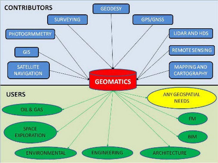
In the U.S., the term “geospatial” is commonly used to refer to a broad range of geography-related technologies used in everything from homeland security to flood plain mapping. The lesser-known phrase “geomatic engineering” is an all-inclusive description of the science that comprises photogrammetry, GIS, surveying, remote sensing, satellite navigation, geodesy, GPS/GNSS, LiDAR, and mapping and cartography. The study of geomatics also incorporates mathematics, computer science, and engineering.
The traditional university structure of subject matter “silos” was an obstacle to the development of comprehensive geomatic engineering programs in the U.S., although the concept has been popular in Canada since the 1990’s. In the U.S., expanding the scope of STEM (science, technology, engineering, and mathematics) is helping to form a solid foundation of understanding for the further study of geomatics.
Geomatics engineering combines the use of spatial information with the practical application of scientific and technical knowledge. In the broadest definition, geomatics deals with measurements in the context of the Earth; however, to plan and complete major infrastructure projects, engineering firms need more than just data. They use accurate spatial information combined with other technology to make decisions and arrive at the optimal approach to any project. Applying geomatics tools to solve real-world problems requires an intimate knowledge of both the problem and of the geomatics technologies available.
The study of geomatics prepares students for job opportunities in an expanding number of industries that use geospatial data, such as oil and gas, space exploration, environment, engineering, architecture, and facilities management, and non-traditional fields such as health and finance. A person with this integrated knowledge can help almost every industry to become more accurate and more efficient, with better faster solutions. As our reliance on geospatial information in our daily lives continues to increase for everything from navigation to national security, geomatics experts will be in demand on a global scale.
As an example, the Geomatics Engineering and Geographic Information Systems (GIS) graduate program at the University of Colorado Denver (UCD) is administered through the Department of Civil Engineering, entirely online through Internet-based courseware and web-conferencing technologies. Before 2012, few classes crossed over between the individual engineering and surveying practices. With new capabilities in software and technology, integrated coursework leading to an awareness of how the specialties relate to each other is increasingly valuable.
By creating a holistic approach to geomatics education, as well as improving the process to establish credentials, higher education institutions are producing well-rounded professionals with the ability to perform services and advance scientific development in all interrelated areas.
What are Geographic Information Systems?
GIS refers to an information system used to store and manage geographic data collected in the field or gathered from other data sources, such as satellite imagery, demographics, population statistics, tax parcels, road networks, land use/land cover maps, etc.
The power of GIS lies in the ability to view and analyze multiple data layers in relation to one another. In addition, the software can be used to create more spatial data by digitizing roads, buildings and streams viewed on maps or imagery. Relational databases are useful for answering queries to extract information from the data.
For example, to select a location for a new retail store, the company may query the database to extract all areas that meet a certain criterion for population and average household income.
There is more geographic data available today than ever before, thanks to high-powered scanners, robotic total stations, large-format aerial cameras, satellites, drones, etc. Without geographic information systems, managing this large volume of data would be an impossible task, and the full value of the information could easily be overlooked.
Land surveyors use GIS to improve efficiency and facilitate project planning before they start. Reviewing zoning, road networks and environmentally sensitive areas or researching historical maps can be part of the pre-field work investigation. During a project, surveyors use GIS to monitor progress of their own data collection efforts to avoid data gaps.
The development of the first GIS in the ’60s dramatically changed how geographic data are used. By keeping data in a centralized location in a compatible format, multiple users can access the information. GIS was a breakthrough for improved management, storage and analysis of layers of geographic data and today GIS is a separate geospatial discipline focusing on hardware, software and relational databases.
In a different context, the term GIS can also mean Geographic Information Science, which refers to the science behind the data structures and computational techniques that allow geographic information systems to collect, store and manage data. In 2006, the American Association of Geographers released the Geographic Information Science and Technology Body of Knowledge (GIS&T BoK). Used as a foundation for geospatial curriculum, the BoK records all areas of knowledge and abilities that make up the field of geospatial technology. Under the guidance of the University Consortium of Geographic Information Science (UCGIS), the digital form of the GIS&T BoK launched in 2016 is continuously updated and augmented to reflect evolving technology.
Enhanced Efficiency and Better Results
In North America, a typical large infrastructure project might encompass the construction of a new pipeline or electric transmission line that impacts many constituencies. The construction may advance through a variety of topography and land cover, intersect roads and streams, and affect population centers.
If the solution provider takes the time to fully understand the situation before communicating the options, the resulting impacts to the surrounding area — including people, wildlife, land and water — should be minimized.
Geomatics encompasses a broader range of scientific and technical expertise. To optimize the project results, an engineering firm utilizes multiple kinds of skills, such as land surveying, LiDAR processing and analysis, satellite image processing, and GIS services, during the project design phase and continuing through construction and implementation. The combined use of all the geographic information available results in efficient planning and more accurate results.
Our technical capabilities to measure everything means more information feeding into geodatabases, which allows the interconnectedness of all facets of our communities to be analyzed, displayed, and leveraged to support smarter decisions.
Although sometimes regarded as separate areas of expertise, land surveying and GIS are complementary disciplines, as are LiDAR, photogrammetry, remote sensing, etc. As all contribute to an integrated knowledge base, the whole picture is more valuable than the sum of its parts when measuring, designing and building our environment.
This article was originally posted on www.pobonline.com.
