Hurricane Resiliency
Corps Releases Final Report on $29B Texas Gulf Coast Hurricane Defense Plan
The new Water Resources Development Act (WRDA) includes $21.4 billion in federal funds for an estimated $34.4 billion plan to protect the Texas Gulf Coast’s residents and infrastructure against hurricanes and storm surge with a series of coastal storm risk management and ecosystem restoration projects.
Rendering courtesy of the U.S. Army Corps of Engineers
A $28.87 billion plan to protect the Texas Gulf Coast’s residents and infrastructure against hurricanes and storm surge with a series of coastal storm risk management and ecosystem restoration projects took a step closer to reality Sept. 10 with the release of a final feasibility report and final environmental impact statement from the U.S. Army Corps of Engineers and Texas General Land Office (GLO).
The study looked at more than 3,300 miles of estuarine shoreline from Cameron County at the southern point of Texas to Orange County on the border of Louisiana. It recommends “multiple lines of defense for the Texas coast.”
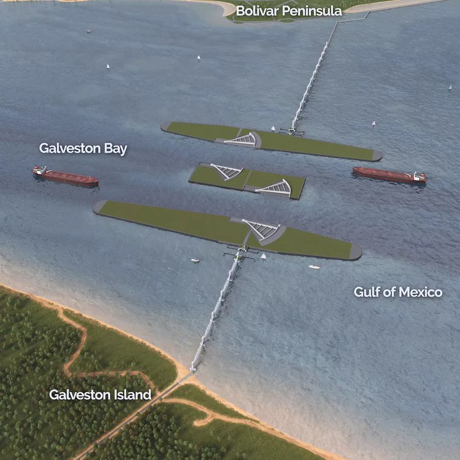
The largest piece of the plan calls for the construction of a storm barrier — nicknamed the “Ike Dike” after it was conceived following 2008’s Hurricane Ike — in the Houston Ship Channel between the Bolivar Peninsula and Galveston Island. The barrier would include 15 vertical lift gates, each 300 ft wide, that can be lowered into place during a storm, plus a pair of 22-ft-tall gates that would close across 650-ft-wide navigation channels, and a pair of 150-ft-wide gates where smaller vessels would pass.
In addition, the proposal calls for the construction of an 18-mile Galveston Ring Barrier System with two surge gates on the western side of Galveston Bay, as well as improvements to Galveston Island’s 10-mile seawall and to 43 miles of beach and dune segments on Bolivar Peninsula and West Galveston Island.
Plans for this multiple lines of defense strategy first took shape after Hurricane Ike caused an estimated $30 million in damage to the Texas Gulf Coast, according to the National Hurricane Center. That’s when leaders from the local to federal levels said “enough,” according to Army Corps of Engineers Galveston District Commander Col. Tim Vail.
“There were — and are today — so many people who believe we could make the Texas Coast a representative model of not waiting for a disaster to build infrastructure that would be resilient, robust and include redundancies,” Vail said in a statement. “What we have today is a generational opportunity to build a generational project that is going to have generational impacts.”
The report includes other recommendations beyond the Galveston area. On South Padre Island, the study recommends 2.9 miles of beach nourishment and sediment management on a 10-year cycle for 50 years. And elsewhere, it recommends the restoration of about 114 miles of breakwaters, 15 miles of bird rookery islands, 2,000 acres of marsh, 12 miles of oyster reef and nearly 20 miles of beach and dune.
Looking for quick answers on construction and engineering topics?
Try Ask ENR, our new smart AI search tool.
Ask ENR →
Despite the large scale of the project, there are concerns it might not be enough. Phil Bedient, a Rice University professor and director of the Severe Storm Prediction, Education and Evacuation from Disasters (SSPEED) Center, says proposed 14-ft dunes around Galveston likely won’t stop storm surge from a Category 3 hurricane. Ike was a Category 2 storm when it made landfall on Galveston Island.
“Katrina was at 27 ft [storm surge], the highest ever recorded. Ike, in Houston, was at 18 ft on Bolivar,” Bedient says. “So, that dune system will be overtopped.”
Bedient suggests higher storm barriers, like those built in New Orleans, plus the SSPEED Center’s Galveston Bay Park proposal, which calls for dredge material from the ship channel to be built into in-bay barriers, in addition to projects like the Ike Dike, to protect against storm surge.
“We need a coastal spine, we need protection there,” Bedient says. “But it’s a single line of defense that needs to be added on to with additional lines of defense in the bay if you’re going to build a system that’s truly resilient and protective.”
Vail says the Corps would continue investigating alternatives for reducing storm surge and flooding along the Texas coast.
But before any work can be done, the plan needs to be funded. The report now goes to the chief of engineers. Once it’s been approved, the study will be forwarded to the Congressional Office of Management and Budget.
Of the estimated $28.87 billion cost, the federal share would be $17.98 billion, according to the report. The plan will require authorization and funding from Congress. Local agencies, including the GLO and the Gulf Coast Protection District, have signed on as non-federal sponsors of specific portions of the proposal. However, there doesn’t appear to be a set time frame for how long the funding process may take.
The report found a “strong” benefit-cost ratio from the coastal storm risk management projects. The region is home to nearly a quarter of Texas’ population. It also accounts for 30% of U.S. refining capacity and 15.8% of U.S. port cargo.
Distributing anticipated storm damage equally across the 50-year period the study analyzed, the Corps projects that the proposed plan would reduce damages by $2.31 billion per year.
Whatever projects, if any, that are funded will take years to build. The report estimates preconstruction engineering and design will take two to five years after funding, and construction will take another 10-15 years.
Until then, Bedient says, “We’re sitting ducks.”
“If they can start this rolling, then there’s always time to come back in and make adjustments, as often happens on these huge projects,” he says. “The same thing happened in New Orleans. They made adjustments as they went along.”


