Drones Find Sweet Spot in Environmental Engineering
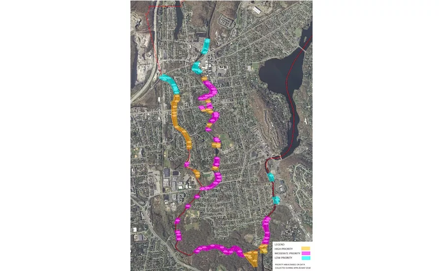
The 11,000 residents of Pompton Lakes’ 3 sq miles live with three rivers, two lakes and spring floods. The town’s flood advisory board pulled KML locations from drone data into Google Earth and a free GIS program, QGIS, to map snags.
MAP BY POMPTON LAKES FLOOD ADVISORY BOARD
The 11,000 residents of Pompton Lakes’ 3 sq miles live with three rivers, two lakes and spring floods. The town’s flood advisory board pulled KML locations from drone data into Google Earth and a free GIS program, QGIS, to map snags.
PHOTO COURTESY OF DRESDNER ROBIN
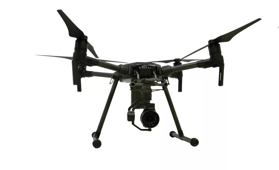
Dresdner Robins’ DJI Matrice 210 UAV runs about $4,500 for a 20 megapixel camera and 15mm lens. Other lenses are about $350 each (Model 200 shown).
PHOTO BY TOM SAWYER FOR ENR
The U.S. Army Corps of Engineers and international organizations from the U.S., England and the Netherlands released on Jan. 19 a 261-page book entitled “Engineering with Nature—An Atlas.” Available either as a hard copy or free download, the atlas showcases 56 projects around the world that apply the principles of an initiative to support engineering with nature, rather than against it, to protect the environment, infrastructure and quality of life.
The EWN movement seeks to leverage natural forces and risk-buffering natural features, such as wetlands and water-courses, to enhance sustainable, resilient, multipurpose infrastructure systems. The initiative includes a network of research projects, field demonstrations and communication activities with an emphasis on embracing innovation.
One technology finding a sweet spot in EWN is drones, which have the ability to scope project areas, survey sites and monitor project execution and performance over large areas of difficult terrain swiftly, safely and repeatedly, with a light touch on the environment.
“We are making more and more use of drones,” says Todd S. Bridges, the U.S. Army’s senior research scientist for environmental science at the Corps’ Engineer Research and Development Center in Vicksburg, Miss. He is national lead on the EWN initiative.
Bridges says drones give planners a superior vantage point, particularly over coasts and wetlands, not only as they engineer a project, but also as they monitor construction and results. “Getting elevation data is pretty important, and getting good data can be hard to do,” says Bridges. “It can be a very convenient place to have a drone that is fixed with Lidar, in cases where a few inches really matter.” He says stand-off measurement technologies help monitor the environment and its evolution. “You have to be able to understand the environment if you are going to engineer it—especially for processes operating at landscape scale.”
Monica Chasten, project manager in the operations division of the Corps’ Philadelphia District, says her group has used drones to help document and monitor progress on several EWN projects in New Jersey, including the Mordecai Island project on p. 86 in the Atlas. Another use was on a “thin layer placement” application of dredged material to restore marsh near Avalon, and construction of two nesting habitats near Ring Island. More drone use is planned at the Seven Mile Island Living Laboratory that the Corps has established in back bays near Avalon.
Several project managers with the Nature Conservancy also report making increased use of drones for streambed restoration for the same reasons, and individual consulting fi rms are picking up local projects for this as well.
Looking for quick answers on construction and engineering topics?
Try Ask ENR, our new smart AI search tool.
Ask ENR →
Greg Gloor, a surveyor with New Jersey civil and environmental engineering firm Dresdner Robin, used a drone to provide pro bono services to a citizens group in Pompton Lakes, N.J., led by Lauren Venin, a landscape architect and certified flood plain manager with the firm. Her volunteer group, the Pompton Lakes Flood Advisory Board, wanted to locate and rate the flood risk posed by downed trees and debris dams blocking three rivers in the town. A heavy snow in spring 2018 left a lot of tree damage on the banks. The board wanted to help the town scope the problem and plan remediation.
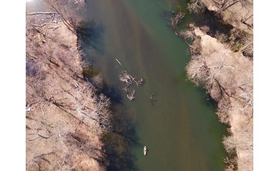
Venin says Gloor developed a methodology and conducted 11 flights to capture a continuous strip of high-resolution images of 6.5 miles of waterways. “Several show debris blocking more than half of the channel,” she says. “Most were fallen trees.”
The board brought the drone’s KML output into free QGIS software for data organization, and tagged and ranked the severity of 96 obstructions on aerial photos mapped to locations on Google Earth. The borough passed the data to its engineers to develop a work plan.
“We found it to be a lot more accurate than previous assessments that were done entirely by volunteers without a professional surveyor.” She said that by basing the report on drone photos tagged to the GIS program, planners now know “it is exactly there, and you can attach a latitude and longitude to it and see exactly what needs to be addressed.” Another benefit is that the study helped town residents qualify for reduced federal flood insurance rates that save them $300,000 annually.
“It’s definitely something that can be done quickly, easily and safely—and speaking as a volunteer, safety is a big deal,” Venin says.
Gloor, who planned and executed the mission, calls the DJI Matrice 210 he used “a beast.” He says he picked it because it can carry a variety of sensors and a camera with interchangeable lenses for three different angles of view — even two at a time. It also can look up, not just down, and is weather resistant, small enough to pack in a car and easily assembled for fast mobilization. It’s heavy enough to be stable in bad weather and has a flight time of about 20 minutes, “although 10% or 15% less in weather below 35º F,” he says.
Gloor says he used these steps to plan his river mission:
- Review the river segments in Google Earth and find a minimum/maximum base image width of the distance between the tops of banks.
- Multiply base distance by 1.5 to 2 for variance and to allow for a context view of the overbank areas
- Determine the altitude to fly with the selected lens to get that width in the frame.
- Determine the top-to-bottom image height (ground coverage) that will be captured at the desired altitude.
- Solve for speed so 80% of the image height is travelled in 2 seconds (the max rate his UAV can capture images) to get a series of images overlapped by 20%.
- Check FAA airspace for restrictions on UAV use in the area.
- Use flight planning software to plan a route on river centerline, including takeoff and landing points. Anticipate battery consumption.
- Scout takeoff and landing points, line-of-sight distance for each segment, obstacles and hazards. Take note of birds!
- Execute as weather permits.

