 A new 33-ft-long bridge on Cape Cod’s heavily traveled Route 28 stands to play an outsized role in combating sea-level rise.
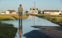
Nestled just north of the Nantucket Sound in Yarmouth, Mass., the Parkers River Bridge is located downstream from a shrinking salt marsh. But a $4.8-million project to increase the bridge’s span to 30 ft from 17 ft will restore natural tidal flow, helping to sustain the wetlands, says Kristen Ferry of the Massachusetts Dept. of Fish and Game’s Division of Ecological Restoration. “Salt marshes buffer the effects of sea-level rise and storms,” Ferry says. “This project in particular has very good migration potential or the potential for that salt marsh to expand and grow.”
Ferry says the existing 85-year-old bridge acts as “a plug in a bath tub” that traps water in the marsh after big storms that can flood nearby homes.
Funded in part by a $3.4-million Hurricane Sandy Coastal Resiliency grant, the project is expected to begin construction next year. To maintain traffic in both directions during construction of the dual-lane span, crews will build one lane at a time. They also will install a special conduit underneath the bridge deck to carry critical utilities, such as fiber-optic lines.
Furthermore, Crews will take care to protect sensitive marine species in the habitat adjacent to the bridge. “I call this my big little problem,” Ferry says.
The bridge is indicative of the kinds of small but high-impact projects Cape Cod officials view as their best hope for fighting climate change. While the Cape is known for its wealthy tourists and seasonal residents, its year-round population is among the state’s oldest and poorest.
With such a small tax pool to draw from, Cape Cod can’t afford large-scale infrastructure projects.


Post a comment to this article
Report Abusive Comment