Spillway Opens as Mississippi Floodwaters Flow Southward
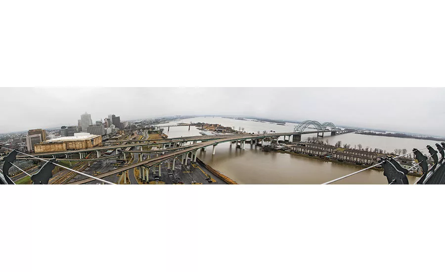
Flood Control The Mississippi River, at its crest, stretched almost four miles wide in Memphis before the Corps of Engineers opened the Bonnet Carré Spillway bays north of New Orleans. Photo courtesy Jeremy Bell, USACE
Flood Control The Mississippi River, at its crest, stretched almost four miles wide in Memphis before the Corps of Engineers opened the Bonnet Carré Spillway bays north of New Orleans. Photo courtesy James Threlkeld, The Advocate
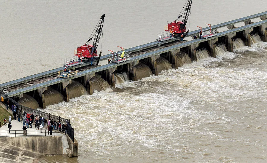
The flood-swollen Mississippi River began moving through part of the Bonnet Carré Spillway, north of New Orleans, on Jan. 10 as part of a strategy to “make room for the river” and avoid more flooding, which had damaged parts of Missouri earlier.
That day, a U.S. Army Corps of Engineers crane started lifting the 11-ft wooden “needles” from the first of 20 bays to divert the river to Lake Pontchartrain and, eventually, the Gulf of Mexico, bypassing New Orleans and limiting flow there to 1.25 million cu ft per second. Further, the move would hold the river crest to 17 ft, safely below the 20-ft levees.
Another 18 of the spillway’s 350 bays were to open the next day, and future action would depend on flow at the mile-wide spillway and in New Orleans, Corps spokesman Ricky Boyett says. “We go by what the flow is,” he says. “Whatever is in the river in excess of 1.25 million cfs, we will divert.”
Bonnet Carré last saw action in the 2011 flood, when 330 bays were opened by lifting the 12-in. by 8-in. by 11-ft wooden needles and storing them on top of the spillway—a labor-intensive process.
The Bonnet Carré, completed in 1931, is one of two Mississippi flood-control diversions. The other is the Morganza Spillway, which moves water into the Gulf through the Atchafalaya River Basin. The spillway wasn’t used this time because, on Jan. 17, the projected flow would be 1.44 million cfs, less than the 1.5 million cfs in the operational “trigger.” The river was expected to reach 57 ft at the structure two days earlier.
In 2011, opening spillways and other actions prevented $170 billion in damage, said Maj. Gen Mike Wehr, commander of the Corps Mississippi Valley Division, at the Jan. 10 opening.
The Mississippi is held back by more than 2,000 miles of levees, says Bob Anderson, spokesman for the Corps’ Vicksburg District. Plans call for improving more than 300 miles of levees in the coming years, he adds. Crews from the Corps’ Memphis District had been ready to move to the Birds Point-New Madrid Floodway to open the levee and flood farmland to divert the river, as they did in 2011.
Looking for quick answers on construction and engineering topics?
Try Ask ENR, our new smart AI search tool.
Ask ENR →
But the river crest did not reach the point at which diversion would have been needed. The crest continued to be lower than projected at both Cairo and Memphis. “There has been nothing flooded [along the Mississippi] that was not designed to be flooded,” says Don Riley, senior vice president at Dawson & Associates Inc. and former Corps deputy commanding general, citing Birds Point, Bonnet Carré and Morganza as well as actions to move backflows into tributaries. “What they have done in past years is [to] set back levees to increase the size of the floodplain,” he says, adding that a study is underway to do the same thing in the Upper Mississippi Basin.
By moving the levees back from the river, the Corps is employing one of the strategies used in the “Room for the River” effort, a $3.3-billon flood-control project nearing completion in the Netherlands. There, other Dutch strategies include excavating floodplains, deepening summer riverbeds, lowering groins to prevent flow obstruction, creating temporary storage areas and adding a channel to the Waal River at Nijmegen.
The Corps also has added relief wells to levees to divert water into drainage ditches and aid monitoring. Clear water flowing from a relief well shows it’s functioning properly. Clouded water indicates the presence of soil and, possibly, other problems.
“We learned a lot in 2011. We … saw how water acted,” Boyett says. “We addressed areas where we had erosion and significant seepage.”
Work since 2011 also has included repairing a Lake County, Tenn., levee, where a scour caused an 80-ft crevasse when the river threatened to cut across farmland and carve out a 9-mile stretch, says Andy Simmerman, a Corps engineer who worked on the Meriwether-Cherokee repair.
The $28-million, three-year job restored 2,700 ft of top-bank scour, adding 700,000 tons of stone and 1.2 million cu yd of dredge fill, he says.


