New Orleans Braces As Mississippi Swells
| + click to enlarge |
 The Army Corps Of Engineers |
| + click to enlarge | 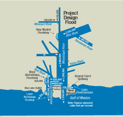 The Army Corps Of Engineers Flood management system extends to Illinois, with controls to divert flow. |
The U.S. Army Corps of Engineers is closely monitoring rising flows on the Mississippi River to determine if the Bonnet Carré Spillway in Norco, La., must be opened in the coming days to divert floodwaters from New Orleans. Heavy rain in the Arkansas, Upper Mississippi and Ohio River valleys have prompted advance preparations for what could be the ninth opening of the Bonnet Carré since it was constructed after the Great Flood of 1927.
If Brig. Gen. Michael Walsh, commander of the Corps’ Mississippi Valley Division in Vicksburg, Miss., gives the order, it will take only two cranes, a small labor crew and 36 hours to divert as much as 20% of the flow of the Mississippi away from the city. Once the structure is opened, water will flow across the 8,000-acre spillway and into Lake Pontchartrain, through which it can exit to the Gulf of Mexico, bypassing the city.
“The Bonnet Carré is the final structure on the Mississippi River Drainage Basin, which means 41% of the U.S. gets drained through here,” says Christopher Brantley, project manager for the spillway during an interview on site on April 7. Brantley, who holds a Ph.D. in oceanography and coastal sciences, added, “Seventy percent of the nation’s water flows past our window.”
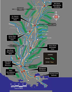
Located 28 miles north of New Orleans, the Bonnet Carré is the southernmost structure of the multi-state flood-control system for the Lower Mississippi Valley: the Mississippi River and Tributaries Project. The MR&T was authorized by the Flood Control Act of 1928 to protect the alluvial valley between Cape Girardeau, Mo., and the mouth of the Mississippi.
The Bonnet Carré structure is a 7,700-ft-long, leaky weir with 7,000 ft of weir openings. The 350 weir openings are 20-ft bays, each plugged by 20 creosoted timbers, or needles, dropped in vertically. The needles are pulled to open the structure when the Mississippi River velocity exceeds 1.25 million cubic ft/second and is forecasted to increase. “The river can safely pass 1.3 million cfs to New Orleans without damaging river levees,” Brantley says. “We are right about 1.2 million cfs now, and it’s rising every day.”
|
If Gen. Walsh orders the opening of the Bonnet Carré, crews will begin the labor-intensive process of removing the 7,000 needles. “There are high and low bays, to prevent the river from concentrating flow at one spot,” Brantley says. Although the structure is designed for 250,000 cfs, the Bonnet Carré has exceeded that flow at least twice in recent history, he adds.
On April 7, with no needles pulled, the leaky weir was allowing a flow of about 5,200 cfs. “We’ve measured up to 7,000 or 8,000 cfs without any bays open,” Brantley says. The structure has only been opened for 281 days since 1936 about 1% of its life.
A bulge of high water is now moving down the river. “On April 7, the gauge at Cairo [Ill.] was at 52 ft,” says Gerald Colletti, assistant chief of operations for the Corps’ New Orleans District. “It has crested and should start to drop over the next five to six days.” However, those decreasing levels mean little to points farther south if rain continues to fall throughout the Mississippi Valley, Colletti adds.
Although the MR&T system includes other flood-control features to reduce flow upstream (see map, preceding page), it has not been necessary to implement flood plans at the Birds Point-New Madrid floodway above Cairo, the Morganza Spillway at mile 280 or at Old River Lock at mile 301, says Pam Vedros, public affairs officer with the Mississippi Valley Division.
However, water in late March began spilling over a 49-ft-elevation “potato ridge” levee at the Morganza Spillway. That spillway consists of an 8,000-acre parcel of land bordered by the agricultural levee, two stretches of the federal levee and the 126-gate Morganza Control Structure. The system there is designed so that when the Mississippi reaches high-water levels that threaten to flood below Morganza and points south, water spills over the potato levee and is contained by the control structure and levees. Gates on the control structure gradually release the water to flow through a 20-mile-by-5-mile floodway that leads to the Gulf of Mexico via the Atchafalaya Basin Floodway. The only time that floodway was completely filled and the structure fully opened was in 1973, says Russell Beauvais, operations manager for the Old River Control Structures.
By April 15, river levels at the Red River Landing by the Old River Lock at mile 301 are expected to be 58.5 ft. “That’s when we will hit 17 ft locally in New Orleans,” Colletti says.
The New Orleans District has activated flood-fight procedures, including daily inspections of all Mississippi River levees, Atchafalaya River levees and flood-control structures within the MR&T system. Even though the Bonnet Carré is at the end of the system chain, it is usually the first to go online, Brantley says. That’s because the primary concern is over velocities that cause scouring, not necessarily levels.
On April 1, the Corps took advantage of rising water levels to run a test on a portion of the spillway. Crews practiced removing and replacing needles at bay 305. The Corps performs tests annually when water is over the weir and jetting between the needles to simulate the conditions that would be in place during an actual opening. It takes about an hour to lift and replace the needles in a bay.
On April 5, the Corps ordered removal of sand-hauling and excavating equipment from the spillway’s 8,000 acres of federally owned land. When not being used for...


