Saturated Watersheds and Stormy Forecast Worry Flood-Control Officials in the Heartland
As spring approaches, officials from Minnesota to New Orleans are eyeing Mississippi River levees—already lapped by higher-than-normal water levels—and bracing for likely floods.
“There is an above-normal probability of major flooding on the Mississippi River this year, all the way up to Minnesota, but especially north of St. Louis,” says Bill Frederick, National Weather Service (NWS) meteorologist and liaison with the U.S. Army Corps of Engineers Mississippi Valley Division.
“The Mississippi Valley Division and all its six districts are prepared,” says Brig. Gen. Michael Walsh, commander and president-designee of the Mississippi River Commission. Walsh says districts get ready by updating flood-fighting teams, training new members, performing drills and coordinating with levee district authorities. The Corps is “fully committed” to reducing the risk of damage from floods, he says.
Conditions are ominous. Heavy rains since last fall have saturated watersheds. River levels already are at heights typically not seen until spring. And, due to a colder-than-normal winter and frozen ground, soil-moisture values are higher than they’ve been in 25 years, Frederick says. High soil moisture means less rain can be absorbed, so it will run into the river. “In most areas we are in the top five percent for soil-moisture values,” he says.
Heavy snow pack north of St. Louis and on the Ohio, Illinois and Missouri rivers’ watersheds is a concern, but the real issue is how it will melt and how it will be affected by rain. Snow melt caused by rising temperatures should raise river levels gradually, but if rain melts the snow quickly, “substantial flooding” would result, Frederick says. The present storm-laden El Niño weather patterns are expected to continue through spring. “El Niño typically causes flooding in April or May,” Frederick says. “We are hoping that we have some of this snow melted before rains hit.”
Historically, some of the Mississippi Valley’s worst floods have been in El Niño years, including 1973 and 1983, when the Cairo, Ill., gauge reached 55 ft—18 ft above average. The NWS also predicts continued colder temperatures, which is another bad sign, Frederick adds. “If we continue to have colder temperatures up north, we’ll get into the rainier part of the season and have melt-off,” he says.
Different phases of flood-fight response are triggered by river stages and local conditions, says senior technician Wayland Hill, hydraulics branch, water-control-management section, at the Corps’ Vicksburg District. In some areas, the response already has begun: frequent inspection of levees and structures, coordination with levee districts and emergency operations, inventorying of materials and restricting access to levees.
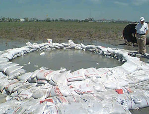
Reynold Minsky, president of the Fifth Louisiana Levee District in Lake Providence, La., says he’s seeing “very unusual” signs, including sand boils earlier than normal and farther away from the river—up to two miles from the levee in one location. “Some of our worst sand boils are a quarter-mile away from the base of the levee,” Minsky says. “I’m very concerned about the integrity of the levees, with saturated ground, saturated levees and boils we’ve never seen before.” The district is doing daily inspections and making preparations to sandbag the land-side base of levees if river levels rise.
Since Mississippi River levees are built primarily of clay, through-seepage is not a problem, Walsh says, and “routine measures” should control underseepage.


