Water Delivery System Analysis and Management Software Brings New Efficiencies to Utility Systems
Municipal water delivery systems around the world range from the rudimentary to the mind-bendingly complex. And their customers regard the water those systems deliver as either rare, precious and costly or overabundant to the point of inconsequence and cheap. But although many users take the water delivery systems themselves for granted, when they fail, perform badly or their managers seek funds to improve, many ratepayers can be counted upon to howl in complaint.
Water-system managers walk a tightrope between the imperative to deliver reliably clean water and limit harm during emergencies and the need to improve reliability and expand systems to support economic growth—all without hiking water rates.
Among more and more water systems of all sizes, from major cities to rural localities, the balance bar those tightrope-walking managers use are not just powerful computers. They also are adopting improved water-utility modeling software that can analyze a deluge of data about the networks of water pipes beneath the ground.
These systems are helping teams fine-tune the operation of pumps and valves and storage facilities so they can anticipate shifting demand, plan for construction, analyze systems for emergencies and search for improvements and cost-saving efficiencies.
"Software and computers today are so much faster now, you can run things in seconds that, in the old days, would take all day. And then we have genius programmers who can make things run more efficiently, as well," says Thomas M. Walski, senior product manager for the water sector at Bentley Systems Inc., one of the leading water-management software vendors, speaking of current industry trends.
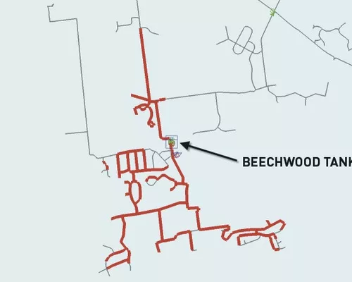
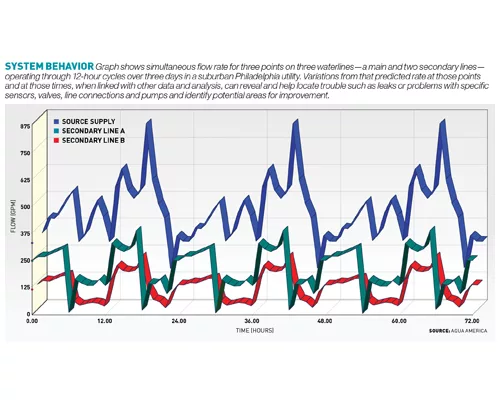
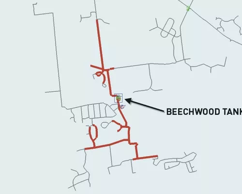
Albert Polidori, hydraulic modeler with Aqua America, adds, "With water-system hydraulics models, we can get steady-state snapshots or extended simulation runs of the model over hours, days, weeks—[up to] as much as 31 days," he says. Aqua America's numerous utilities include a concentration of linked systems serving suburban Philadelphia,
Polidori says innovative data collection and analysis techniques are providing utilities with better insight into systems. They are building on their use of graphics to help interpret data and geographic-information-system (GIS) data about real-world physical characteristics—elevation, pipe-section lengths, connection types, control features and friction coefficients, among others—for any given run of pipe. Also, he adds, "We have [better integrated] data" about "how much customers are using on a daily basis."
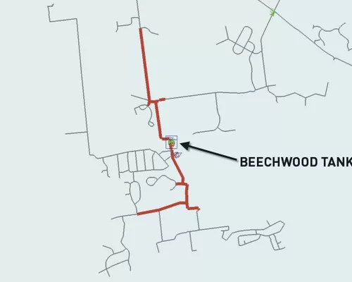
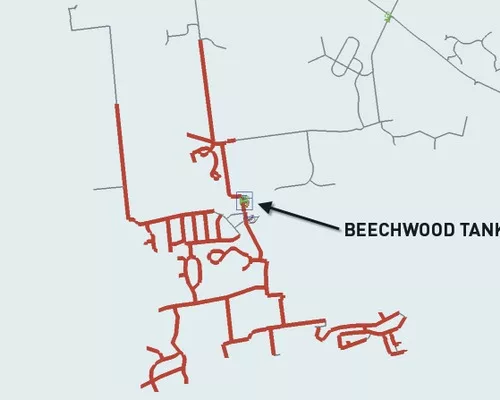
Michael T. Brown, senior project manager and principal engineer in the Harrisburg, Pa., office of Gannett Fleming Inc., recently completed building a system to semi-automate the integration and updating of ever-changing data from GIS and billing records, as well as industrial system control and acquisition data (SCADA) that comes from key supply and control features, into a hydraulic model for a large system run by the Lehigh County Authority (LCA) near Allentown.
Although the concept of integrating water-system models with other data sources is not new, examples of SCADA integration with these systems are rare and much more difficult to integrate and GIS data, adds Brown. The LCA project succeeds in part by establishing new data-collection and data-entry procedures, as well as software to automate imports that should promote process benefits for years, Brown says.
By collecting SCADA data from sensors and control points such as pumps, valves and tanks, engineers gain metrics to compare to the model's theoretical performance at those locations. They look for variances between the two—the delta—that suggest either modeling errors, system inefficiencies, such as misset valves, or trouble such as leaks or broken lines. As they work on those and refine the correlation between the hypothetical world represented by the model and the data readings—or, as Brown says, the "thin the line between hypothesis and field data"—the model's accuracy increases so it can be used with confidence for planning and experimentation. "It is a decision-making or a what-if tool for planning," Brown says.


