Texas Toll Road Tries Satellite Sensing for Maintenance
SH130 benefits from data-rich InSAR measurements for maintenance troubleshooting.
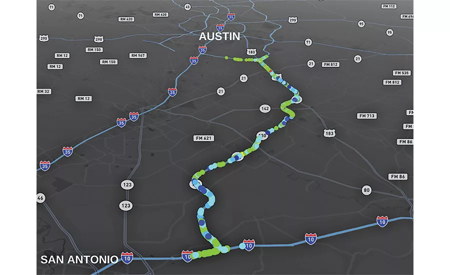
Image courtesy of SH130 Concession Co.
A Texas toll road operator has turned to the sky for solutions to a very down-to-earth problem: roadway maintenance.
The State Highway 130 Concession Co. is using satellite technology to monitor a 41-mile southern section of SH130—one of the first such uses in the U.S.
The concessionaire for the toll road that stretches between San Antonio and Austin has partnered with EO59 to use satellite remote sensing technologies to evaluate roadway conditions with millimeter accuracy and identify problems before they impact safety or ride quality.
“This is one of the very first comprehensive ongoing maintenance monitorings of a long stretch of a substantial roadway in the U.S.,” says Doug Wilson, CEO of SH130 Concession Co. “And if it proves cost effective, then the hope would be others would take advantage of it.”
The key to the approach is interferometric synthetic aperture radar (InSAR), which creates high-density measurements by using radar signals from Earth-orbiting satellites. InSAR imagery permits the monitoring of data representing a wide area at all times of day or night, in any weather conditions.
InSAR images are produced by comparing multiple measurements over time and creating maps called interferograms. These maps show ground-surface displacement to a high degree of accuracy, typically in the scale of millimeters.
The SH130 concessionaire uses InSAR maps that measure more than 30,000 points along the roadway every six days and compares them to seven years of historical data. They can then identify specific areas for inspection teams to visit and evaluate, making repairs if necessary.
“There will always be a need for in-person visual inspections, but the satellite monitoring allows us to identify areas to concentrate on long before they would be noticed through visual assessment,” says Jeff Billows, chief operating officer at SH130 Concession Co.
Looking for quick answers on construction and engineering topics?
Try Ask ENR, our new smart AI search tool.
Ask ENR →
That’s helpful in Texas, where maintaining a roadway is complicated by one key factor: clay. As in much of the state, the soils beneath SH130 contain a lot of clay. The tendency of clay soils to expand and contract in the presence or absence of moisture can affect the asphalt road surface substantially if left unattended.
Prior to his arrival in Texas, Wilson headed the concessionaire for the tunnels under the Elizabeth River between Portsmouth and Norfolk in Virginia. During that time he became familiar with InSAR technology being used to monitor the impacts of sea level rise in the Chesapeake Bay area, along with one of the companies performing the work, EO59.
The Richmond, Va.-based technology company specializes in creating software that can be used to collate satellite data for specific uses. In 2021, following the sudden collapse of a condominium building in Surfside, Fla., EO59 used its ground-monitoring technology to examine other structures in the city.
For the work on SH130, EO59’s team accessed available historical satellite data going back to 2015 and then created a specific algorithm that can evaluate that information and track the changes of the roadway.
“We have to use a handful of different algorithms to look at structures, road surfaces and embankments,” explains EO59 founder and CEO Carl Pucci. “At the same time we’re also comparing this information to things happening at different points in time, so it’s multitemporal processing radar data.”
InSAR technology emerged in the 1960s but remained relatively obscure for the next few decades as it was mainly used by governmental agencies. The first civilian satellite was launched in 1978, and several others followed in the decade after.
One of the earliest demonstrations of InSAR technology was in 1992 when it was used to show surface deformation from a California earthquake.
Over the last decade several satellites designated solely to collecting data on ground deformation monitoring have been launched greatly widening the opportunities to use the technology for new purposes.
Until now, InSAR has been primarily employed in the US to identify damage to infrastructure due to disasters; earthquakes in California, sinkholes in Virginia and landslides in Colorado. In terms of monitoring infrastructure, the technology has been used for specific purposes such as monitoring extended MSE walls under construction in Pennsylvania and, notably, ground displacement from a tunnel boring machine in Seattle.
The Washington State Department of Transportation (WSDOT) employed InSAR as part of the $3.3 billion Alaskan Way Viaduct replacement tunnel project in Seattle. As the 57.5-ft-diameter Tunnel Boring Machine (dubbed “Bertha”) ground its way under the city’s downtown, engineers used InSAR as a supplemental monitoring method measuring street level effects of the excavation.
“While survey and Lidar provided detailed information about locations above and alongside the tunnel alignment, InSAR provided a wider view of the ground as it covered a much broader area,” says WSDOT Spokesperson Laura Newborn.
In Europe, InSAR has been used by various agencies to monitor road conditions but the application of the technology like is being done with SH130 has not been done much if at all in the U.S., said says Anil Kumar K. Agrawal a Civil Engineering professor at City College New York who contributed to a study on InSAR technology for the Dept. of Transportation.
“If you are looking at examining a specific location perhaps a drone would be a better idea,” he says, “But if you are looking at a long stretch of highway, that’s a big area and if you want to do regular monitoring InSAR is probably the best option.”
In the past, one of the biggest hurdles facing InSAR for commercial applications has been the sheer amount of data that must be processed. That has changed dramatically in the past five years, Pucci says, as processing power has increased dramatically. Another factor limiting the technology’s wider adoption in the US is the fact the satellites that record the data are almost all of European origin.
For the SH 130 Concession Company, there is also a financial incentive to use the technology. The SH 130 toll road was built by a joint venture between Cintra and Zachry American Infrastructure, the SH 130 Concession Company. In exchange for a $1.35 billion investment into the project, the company received the right to collect tolls for 50 years in a revenue-sharing agreement with the state.
The roadway opened in 2012 but low traffic revenues forced the company into bankruptcy just three years later. The SH130 Concession Company eventually exited bankruptcy in 2017 after the investment firm Strategic Value Partners bought out Cintra's stake in the joint venture.
While the concessionaire operates and maintains the roadway, it remains the property of the State of Texas. The Texas Department of Transportation continues to oversee the contractual requirements outlined in the Facility Concession Agreement.
Among those requirements are stringent standards to maintain the roadway and ensure the flow of traffic with specific penalties for failing to do so. The InSAR data enables the concessionaire to not only react to problems proactively but also document them more thoroughly.
“Now we can show we've identified this issue, made the right remediation, and are taking the right remediation steps and show that it’s no longer a problem,” Wilson said.


