Construction Technology
State Engineering Boards Target Drone Photographers For Unlicensed Survey Work
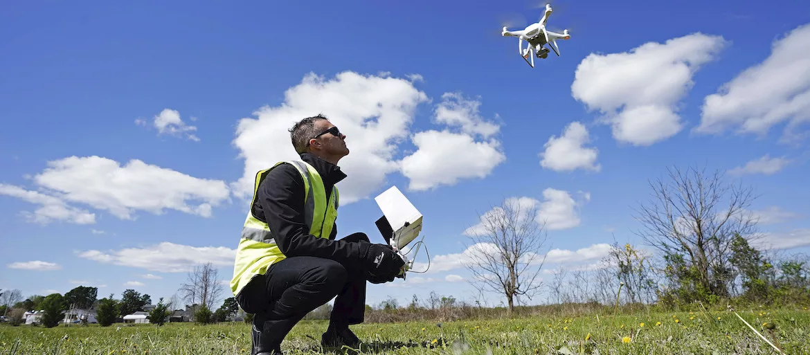
Michael Jones operates his drone in Goldsboro, N.C., but the state of North Carolina issued an order that grounded his drone if used for surveying. Photo: Gerry Broome/AP
Drone photographers have built up a lucrative business offering their services to construction and development firms, helping map sites and track progress on projects large and small. Some state licensing boards for engineers are pushing back, arguing that a new wave of aerial photography entrepreneurs are effectively stealing work from licensed professionals.
The North Carolina Board of Examiners for Engineers and Surveyors, in a federal court document, acknowledges taking action against drone operators it believes cross the line into surveying work.
California's Board for Professional Engineers, Land Surveyors and Geologists typically brings 10-15 cases each year against drone operators it believes are doing unlicensed surveying work.
The board now faces a federal lawsuit from one drone operator, Michael Jones, who says he was forced to stop doing aerial photography work for clients after being hit with the board's cease-and-desist order.
The North Carolina dispute is shaping up to be a pivotal one, having made the leap from sleepy licensing board proceedings to a federal court battle that has generated headlines, including coverage by the Associated Press, which first reported the issue.
In question is where the line will be drawn between aerial photography and related services and licensed land surveying work.
More broadly, the case exposes the uneasy relationship between established state professional boards—whose codes of conduct and standards of professionalism are written to protect the public—and upstart technologies with proven benefits, such as drones, that disrupt and potentially drain resources from established professionals and individually licensed engineers.
Simmering Conflicts Now in Court
While there have been lots of skirmishing online and attempts by state boards to rein in drone operators in recent years, only recently have the disputes escalated into full-blown legal battles. “It hasn’t really boiled over to really serious legal issues until very recently,” says David Benowitz, head of research at the Drone Analyst, an industry research and consulting company. “It has now.”
Looking for quick answers on construction and engineering topics?
Try Ask ENR, our new smart AI search tool.
Ask ENR →
At the center of the North Carolina court case is Jones, a photographer and videographer in Goldsboro.
Jones started experimenting with drone photography a few years ago and soon found work from a variety of clients. His work ranged from taking aerial shots of homes for real estate brokers to mounting an infrared camera and helping a major retailer spot where heat was leaking out of a warehouse.
But in 2018, Jones was hit with a surprise when the North Carolina board sent him a letter arguing that much of his work amounted to surveying without a proper license. The board launched an investigation and sent Jones a final notice in 2019. Fearful he could face criminal charges and unable to pay for a lawyer, Jones grounded his budding aerial mapping business, a move he contends cost him over $10,000.
Still frustrated over the situation, Jones decided to take his case to federal court in January after the Institute for Justice, a free-market advocacy organization, agreed to represent him. he filed a complaint in late March in U.S. District Court in Charlotte, N.C.
North Carolina's engineering board is claiming a license is needed to “draw rough approximations of property lines on images” or to capture and distribute “data about the dimensions or elevations of land, or the size of objects on land.”
– Michael Jones, drone photographer
“This is not a new phenomenon when you have a well-established profession that views an up-and-coming technology and smaller businesses as a threat,” says Sam Gedge, the Institute for Justice attorney working on Jones' case. “Often, when those companies feel threatened by outsiders, they resort to licensing boards to push back against upstart competition.”
The lawsuit charges the North Carolina engineering and surveying board with violating Jones' first amendment rights and overstepping its authority in a bid to rein in potential competition.
The North Carolina board has taken a far more “aggressive” stance on the definition of surveying, extending it beyond setting legal boundaries between tracts of land, according to Jones' lawsuit. The board, Jones contends, is claiming a license is needed to draw “rough approximations of property lines on images,” or to capture and distribute “data about the dimensions or elevations of land, or the size of objects on land.”
“Even stitching aerial photos together using orthomosaic software requires a land-surveyor license,” the lawsuit claims.
Without offering specific details, the lawsuit also states that the North Carolina surveying and engineering board has sent similar cease-and-desist letters to “at least half a dozen companies” over the past few years.
What The North Carolina Board Targets
In particular, the board “targets” firms involved with “aerial photos, data, 3D digital models, and the like,” Jones’ lawsuit claims. “Simply, the projects the Board targets … are speech that is fully protected by the First Amendment,” it says. “Plaintiffs thus bring this civil-rights lawsuit to vindicate their constitutional right to create and communicate images and data about land.”
The North Carolina board, in its response, rejects charges that it is overstepping its bounds, arguing that in its interpretation of what activities fall within the realm of surveying is based on state law.
In its response, the North Carolina board contends Jones “offered services of “Surveying & Mapping” and, at one time, advertised the ability to provide land measurements.”
Asked about the board’s claims, Jones’ lawyer Gedge says the North Carolina board was probably referring to “some of the standard categories that online databases like Droners use.”
Jones, for his part, has said he was “careful not to advertise his services as surveying and instructed clients that his maps were not for legal purposes,” according to an article published on the website of the Institute for Justice.
Getting a surveyor’s license, though, is not a practical option, the Institute contends. An applicant like Jones in North Carolina, who does not have a surveying-related college degree, would have to have 16 years of experience, more than half of them under a practicing licensed land surveyor, in order to qualify, the Institute claims.
Overall, states differ in how they define drone uses in surveying.
How California Board Defines Surveying
In California, the state's Board for Professional Engineers, Land Surveyors and Geologists typically brings 10-15 cases each year against drone operators it believes are doing unlicensed surveying work. All originate with complaints filed by licensed surveyors, says Richard Moore, the board's executive officer.
About one out of five licensed surveyors and engineers use drones in their work, Moore estimates. In addition to fixing legal property boundaries, the California board includes topographical surveying and mapping, either by traditional surveying methods, or by drone, to be covered by the state engineering law.
This sort of work is often done for clients needing information in disputes about easements, which represents considerably more work for surveying firms than simple boundary fixing. In fact, most lawsuits related to land involve not property lines, but easements, Moore said
By contrast, Moore says the California board does not consider the simple act of taking aerial photos by drone as surveying. Photos of homes for real estate brokers don't constitute surveying-related services, for example.
“We don’t focus on the drone,” Moore says. “We tend to focus on what they are doing with it."


