Boston's Moakley Park to Be Model of Climate Resilience
Editor's note: This story was updated Dec. 30 to correct an earlier version, which incorrectly placed Moakley Park in South End, a neighborhood ddjacent to South End.
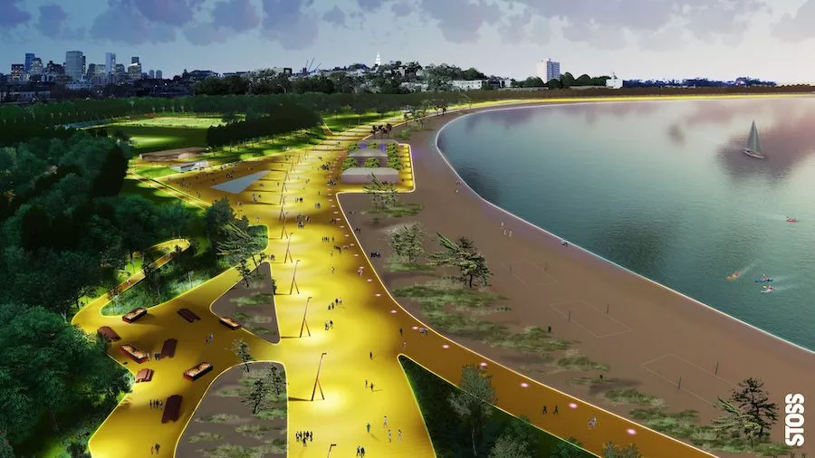
Improvements to Moakley Park—one of Boston’s largest waterfront parks—are a major part of the city’s resilience strategy to protect vulnerable residential neighborhoods from rising sea levels and storm-surge-related flooding due to climate change.
“This is one of the first projects… that is really taking both resilience and social equity together as kind of critical partner in the development of the park,” says Amy Whitesides, project manager for Stoss Landscape Urbanism “Boston is really prioritizing resiliency in advance of any major storms.”
Currently, Stoss and the Boston Parks and Recreation Department are working on preliminary resilience designs with partners including One Architecture and Urbanism, Nitsch Engineering and Weston & Sampson to implement changes to the 60-acre park in South Boston, which experiences frequent minor flowing and is at risk for a major flooding event. In addition, Woods Hole Group is providing verification of the design concepts from a coastal flooding perspective.
The project’s preliminary design phase is being funded by a $1.5 million Municipal Vulnerability Preparedness Action Grant from the Massachusetts Executive Office of Environment and Energy, which has made green infrastructure “a huge priority for the program,” says Mia Mansfield, director of climate adaptation and resilience for the state office.
As of Dec. 1, the design and engineering team had completed baseline technical and pre-permitting feasibility assessments and has started working on coastal and stormwater strategies and resilient landscape design, says Julie Eaton, lead resiliency engineer at Weston & Sampson, project management consultant for the one-year preliminary design phase which began in July.
Improvements to Moakley Park are part of Mayor Martin Walsh’s Resilient Boston Harbor plan unveiled last October. The plan calls for increasing access along Boston’s 47-mile shoreline, while better protecting the city in the event of major flooding. The plan focuses on solutions to reduce risks from the 1% annual chance flood as well as a projected 21 inches of sea-level rise by 2050 and 36 inches by 2070. In addition to protecting communities from coastal flooding, the park improvements will retain and improve sports fields and play areas.
Looking for quick answers on construction and engineering topics?
Try Ask ENR, our new smart AI search tool.
Ask ENR →
The baseline technical assessments included an initial coastal assessment of flood pathway locations and timing, a site survey completed by Nitsch Engineering, preliminary hydrologic and hydraulic modeling, geotechnical and environmental investigations, groundwater modeling, horticultural soils evaluation and traffic analyses, Eaton says.
Findings from these assessments have helped the design team identify initial challenges and opportunities for advancing the Moakley Park Vision Plan, including a berm designed to provide programmatic benefits, such as a sledding hill and flood protection for South Boston communities, she says.
Geotechnical subsurface investigation revealed the site is underlain by compressible soils — such as loose/soft urban fill, organic soils and clays — of variable thickness and composition that are prone to settlement under new loads, Eaton says.
In the park’s schematic design of the estimated 2,600-ft-long flood-barrier berm, grading of the berm ranges in height from 6 ft to 10 ft relative to the existing ground surfaces. “An increase in grades, such as proposed for the berm, will induce settlement of the existing compressible fill, organic soils and clays underlying the site,” Eaton says.
“We’re continuing to work with the design team to advance the berm knowing settlement is a concern,” Eaton says. In upcoming tasks, the team will also evaluate materials for berm construction.
Below ground utilities that would be impacted by the settlement pose additional challenges. “They are very critical community assets with a population that doesn't have quite as much ability to bounce back from flooding event and are in need of protection,” Whitesides says.
Most of the park is filled land, claimed from Dorchester Bay in the late 1800s and early 1900s, Eaton says. Portions of the park were reportedly used briefly as a coal yard and a dump in the early 1900s. Columbia Park was established in the early 1920’s, which was later renamed Moakley Park after the late U.S. Rep. Joe Moakley (D-Mass.), an environmental advocate.


