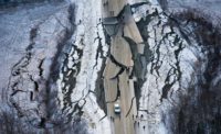
After two of the largest earthquakes in decades hit Southern California over July 4 and its holiday weekend, government officials, engineers and geologists continue to assess the extent of the area’s structural damage. Meanwhile, the U.S. Navy’s largest air weapons testing facility, the Naval Air Weapons Station China Lake located near the temblors' epicenters, remains in mission essential personnel status.
By July 15, the Naval Facilities Engineering Command (NAVFAC) had completed assessments for 70% of 1,384 buildings located on 1.2 million acres of Navy property. On July 10, the base’s Armitage Airfield resumed operations with a first round of U.S. Navy fixed-wing aircraft deployment, said John Scorza, Navy chief mass communications specialist.
“We are partially mission-capable,” said Scorza, who said that flight operation is the base’s most essential function. The U.S. Department of Defense defines fully mission-capable status as the material condition of equipment, aircraft or devices to perform all missions. Mission essential-personnel status refers to people the Navy designates as necessary based on the needs of the base at the time, which he said has been changing and increasing since the earthquakes.
The China Lake facility is in the western Mojave Desert near Ridgecrest and Searles Valley. The base maintains land, facilities and assets that support the Navy’s research, development, acquisition, testing and evaluation of cutting-edge weapons systems.
The base represents 85% of Navy area for that use and 38% of its total land holdings worldwide.
While the base’s buildings are still standing, the Navy does not yet know the extent of the damage. About 47 families were evacuated to Ventura County after the quakes, and the Navy has inspected 192 housing units, of which 49 had damage ranging from gas leaks to structural damage. Six of the housing units remain uninhabitable due to water damage.
On July 5, a magnitude 7.1 quake occurred with an epicenter in Searles Valley, near Ridgecrest, a city that sits in the southern Indian Wells Valley and the northeast corner of Kern County.
The quake, the largest in California in over two decades, followed a magnitude 6.4 foreshock that struck the same area about 34 hours earlier on the morning of July 4.
“In Ridgecrest, structural damage is largely limited to nonstructural elements like finishes, equipment, and contents, however there have been reports of significant structural damage to at least two buildings so far that have led to red tags,” said Maggie Ortiz-Millan, program manager at the Earthquake Engineering Research Institute, a nonprofit, technical society of engineers, geoscientist, and government officials who work to reduce the impact of earthquakes through science and engineering.
The institute currently has field teams on site helping assess damage in Ridgecrest and Trona, Calif., an unincorporated area in San Bernardino County roughly 25 miles east.
“Some failures are clear to see, but others may be obscured by skirting, so it is still unclear how widespread the damage to these structures is,” Ortiz-Millan said. “In Trona, the age of structures means that structural damage is more common, especially among single family homes. Chimney collapses are reported to be common in Trona.”
Meanwhile, building inspectors from Ridgecrest continue to work with assessment teams from the California Office of Emergency Services, FEMA, and the Small Business Administration. Neighboring California cities, including Bakersfield, Shafter, Tehachapi, California City, Lancaster and Palmdale, sent inspectors to aid in the assessment. All roads and hospitals are open while schools are still assessing damage.
California’s Division of the State Architect said it sent from its Los Angeles office five teams of two SAP-certified structural engineers to Kern County to review 14 buildings. An additional team of two SAP structural engineers from the agency’s San Diego office were deployed to evaluate Trona Joint Unified School District.
“Preliminary (verbal) report from Sierra Sands is quite a lot of non-structural damage, particularly to suspended ceilings,” said Jennifer Iida, public information officer at the Dept. of General Services. Meanwhile, Kern County does not yet know the full scope of damage, timeframes for repairs or in-depth cost estimates at this time, said Megan Person, county spokesperson.
“The extent of damage to County of Kern-owned facilities is still being assessed, but there are no largescale, obvious damages observed to date,” said Person, who noted there are varying levels of damage in the area that much is not visible from the street.
According to the U.S. Geological Survey, the July 5 quake occurred 11 km northwest of the July 4 foreshock, at a depth of 8 km or 4.97 miles as a result of shallow strike slip faulting in the North America plate crust and indicates a rupture on a steeply dipping fault, "as the result of either right lateral slip on a plane striking NW-SE, or as left lateral slip on a plane striking SW-NE.”


Post a comment to this article
Report Abusive Comment