Designing a D.C. Gateway
Frederick Douglass Memorial Bridge replacement is a product of focused aesthetic goals
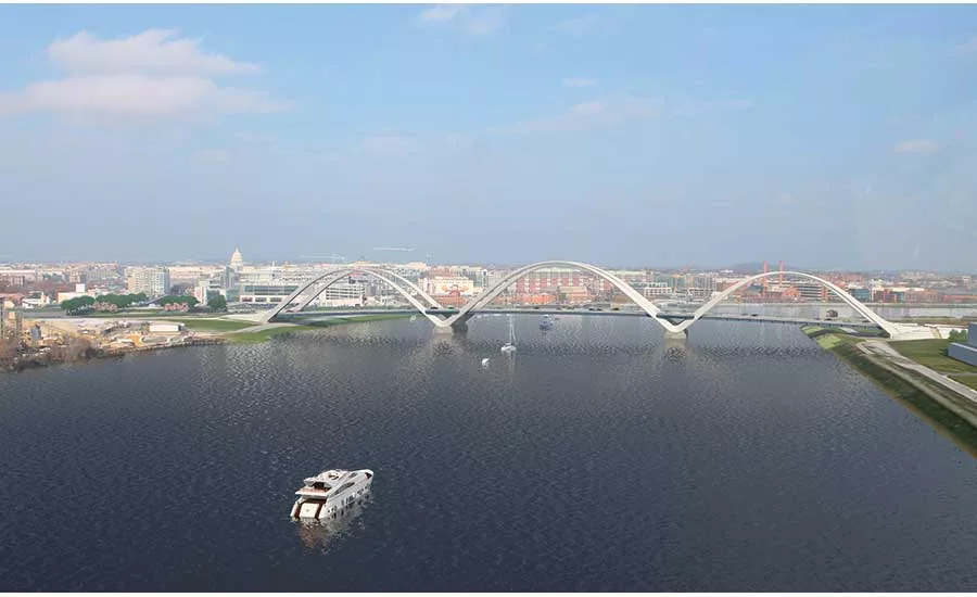
Construction of the new Frederick Douglass Memorial Bridge marks the bicentennial birthday of the abolitionist and civil rights hero.
RENDERING COURTESY OF SOUTH CAPITAL BRIDGE BUILDERS

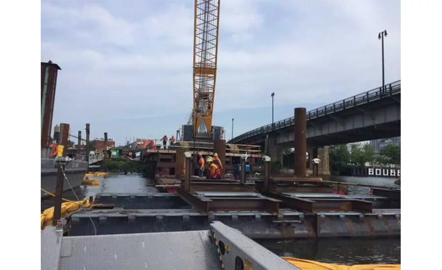
The new Frederick Douglass Memorial Bridge, arising just south of the existing one, will have arches above the deck, unlike other D.C. crossings. Piling work has begun.
PHOTO COURTESY OF SOUTH CAPITAL BRIDGE BUILDERS
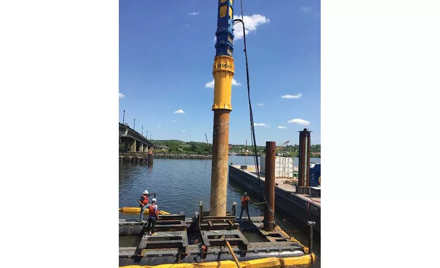
The new Frederick Douglass Memorial Bridge, arising just south of the existing one, will have arches above the deck, unlike other D.C. crossings. Piling work has begun.
PHOTO COURTESY OF SOUTH CAPITAL BRIDGE BUILDERS
The new Frederick Douglass Memorial Bridge, arising just south of the existing one, will have arches above the deck, unlike other D.C. crossings. Piling work has begun.
PHOTO COURTESY OF SOUTH CAPITAL BRIDGE BUILDERS

The new bridge will be at the heart of a planned transformation of the Anacostia shoreline and will improve the auto, bike and pedestrian linkages between the Anacostia neighborhood and Southeast D.C. near the Washington Nationals’ stadium, and on to downtown D.C..
PHOTO COURTESY OF SOUTH CAPITOL BRIDGE BUILDERS
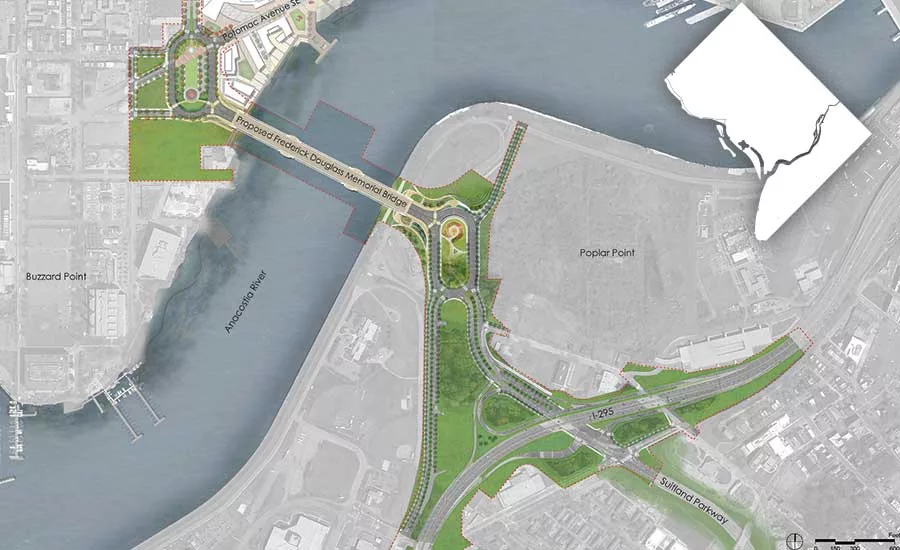
The new bridge will be at the heart of a planned transformation of the Anacostia shoreline and will improve the auto, bike and pedestrian linkages between the Anacostia neighborhood and Southeast D.C. near the Washington Nationals’ stadium, and on to downtown D.C..
MAP COURTESY OF DDOT
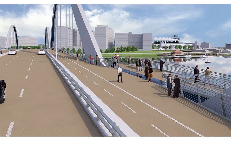
The new bridge will feature walkways and bike paths on both sides and link to the city’s monument core.
PHOTO COURTESY OF SOUTH CAPITOL BRIDGE BUILDERS
Two hundred years after the birth of the abolitionist and statesman Frederick Douglass, construction has begun on a $441-million replacement for a 68-year-old bridge that carries his name. The replacement—which retains the honorific—is rising 100 ft south of the existing bridge. The design strives to honor the black civil rights hero’s legacy by creating a “grand urban boulevard” to link a formerly gritty industrial area on the east side of the Anacostia River with Washington, D.C.’s core. The unusual design features a series of above-deck arches with no external bolted connections.
The District of Columbia Dept. of Transportation (DDOT) began looking in the 1990s for a replacement of the existing swing bridge, which opened in 1950, says Delmar D. Lytle, DDOT program manager. “It’s structurally deficient and functionally obsolete,” Lytle says. “Ever since then, we’ve been engaging stakeholders, looking at the aesthetics of the corridor. This is the gateway to the capital.”
The old bridge carries about 90,000 vehicles a day on South Capitol Street over the Anacostia River to intersect with the Suitland Parkway and Interstate 295 on the southeast bank. DDOT determined that it would be less expensive to replace the bridge than to keep rehabilitating it, says Lytle. Moreover, it will be the marquee star of the 30-year, multibillion-dollar Anacostia Waterfront Initiative launched in 2000 to transform and revitalize 37 miles of shoreline. That initiative also includes the $260-million 11th Street Bridges project, completed in 2012 (ENR 12/12/2011 p. 16).
South Capitol Bridge Builders, a joint venture led by Watsonville, Calif.-based Granite Construction Inc. and Atlanta-based Archer Western, holds a design-build contract—with AECOM as lead designer—to construct the three-span, 1,600-ft-long bridge with three sets of parallel white arches. The bridge will have six traffic lanes and a bicycle/pedestrian path on both sides. An esplanade will grace the Anacostia River’s south bank. Traffic ovals will be created at each end and sections of South Capitol Street will be re-created as a scenic boulevard. Reconstruction of the interchange with the Suitland Parkway and Interstate 295 also is included.
The desire of lawmakers and community stakeholders to have the new bridge be a truly iconic structure drove the process from concept to design to procurement.
Design Drive
DDOT started a draft environmental impact statement in 2007, says Lytle. “We got a final EIS approved in 2011, but that was for a moveable structure. We commissioned a navigation study in 2013-14 to determine if it could be a fixed structure. If we could, we could save $120 million.” That led to a draft supplement EIS in 2014, and the U.S. Coast Guard approved the idea of a fixed structure, as long as it met 150-ft horizontal and 42-ft vertical clearances.
In 2013, the National Capital Planning Commission and the Commission of Fine Arts reviewed the conceptual design, which featured no arches, and the latter group called it “uninspired.” Working with those and numerous other organizations, “we coordinated with all and developed visual quality guidelines for the project,” says Lytle. DDOT developed a manual that referenced D.C.’s existing historic bridges and presented options to competing design-build teams. “The teams came in during procurement to get buy-in from us as to whether the aesthetics of their proposals met our goals,” he says. In selecting the winning team, DDOT weighted technical and price factors at 60 and 40 points, respectively. Aesthetics accounted for 15 of the 60 technical points, says Lytle.
Looking for quick answers on construction and engineering topics?
Try Ask ENR, our new smart AI search tool.
Ask ENR →
The team must meet a substantial completion date of Nov. 30, 2021 or face liquidated damages of $33,000 per day. Final completion is slated for Dec. 31, with LDs of $20,000 per day after that, says Jon Whitney, senior project manager with HNTB, the program and construction manager for DDOT.
“When we started this design-build procurement process, it was really a design competition,” says Ken Butler, AECOM’s national director of bridge services. “There were 15 performance design goals, but basically we had an open canvas.”
Citing D.C.’s Key, Taft and Arlington bridges, Butler observes that “Washington, D.C., is a city with bridges of arches. We looked at some 30 types and boiled it down to arches.” Considering the modern development occurring in southeastern D.C., the team concluded, “Why don’t we go as high as we can?” he recalls.
The three pairs of arches will rise 168 ft above water. “We extended them to the maximum elevation you can go in the city,” says Butler. “The span-to-height ratio is exaggerated to achieve the signature look we went for.”
Also for aesthetics, the design features internal splice connections and no cross-bracing at the tops of the arches. “The unusual variable-depth kite shape of the arches, the unbraced parallel arches, and internal splice connection details for aesthetics all add challenges for both design and erection,” says Butler.
Unlike conventional tied-arch bridges, the three-arch system is designed to allow the superstructure to move freely, with expansion joints only at the ends, as stipulated by DDOT. “The bridge expands and contracts through the arches similar to a glider chair. In a typical tied-arch structure, there’s a tie that carries the tension in the arch. But that requires multiple expansion joints,” says Butler. “In order to avoid that, we did what we do with cable-stayed structures—have the superstructure rest on bearings.”
After the team won the contract in summer 2017, the mayor held a public unveiling of the design. The Commission of Fine Arts again expressed some doubts about the “industrial” look of the design, but then in a Nov. 17 letter to DDOT it stated: “Having had the opportunity to consider more documentation of the proposed bridge in its urban and historic context, the Commission approved the concept.”
Whitney says the nearly complete design is in the process of getting details vetted by the stakeholders, including lighting, signage and landscaping. Moreover, an extensive public outreach effort is ongoing: “We have a community quarterly communications committee to provide updates on the project. We also have an ‘ambassador program’ including folks from the community and the project. They are the boots on the ground going door to door. We have civic association meetings and an advisory commission. Each commissioner represents about 1,000 residents.”
Constraints and Coordination
“It is a challenging site,” says Whitney. “There are a number of environmental constraints.” The city has been trying to clean up the contaminated river, and industrial sites abound. Moreover, “we have a neighborhood on north end of the bridge that is impacted by a lot of construction, including a new soccer stadium nearby,” says Whitney. “There are complaints about traffic, noise, and dust.”
The site is downstream from an old Navy yard. “During the Civil War, they shot cannons across the river into the project area,” says Lytle. “We have potential unexploded ordnance. We alerted the team and it has an expert on site as they begin excavation. They will test for ordnance every five feet.”
Due to the layers of sandy clays and soupy mud, the arches will land in the stream on rectangular piers about 30 ft long by 120 ft wide, and be supported by 60-in.-dia steel pipe piles as deep as 120 ft, says Whitney. “There was concern about using steel piles in the river because the bridge design life is 100 years,” he adds, so the piles have additional corrosion protection, including a sacrificial layer and an epoxy coating.
Because of poor quality soils, the project also will include treatment with lightweight fill, says Eric Hayes, design-build manager for the JV. Test borings terminated at 240 ft deep, he says. The team also conducted a Statnamic load test in which a confined explosive force is exerted on a pile and readings are taken to determine the geotechnical design. In February, crews started building the temporary access trestle that will serve as the work platform for construction in lieu of barges, says Hayes. Construction will ramp up next year, when the team expects to have about 250 craftspeople on site, says Hayes. “Right now is a very intense time as far as the designer having as many as 125 people on the job.”
After completing the substructure, crews will erect the first span of arches and then erect the third span. “We will utilize that third span to help support erection of the center span arches, due to navigational restrictions,” says Hayes. Once all three arches are erected, crews will start building the deck in the center out toward each abutment. The steel grillage deck will be topped by 12-ft-wide by 28-ft-long precast panels. Initially, there will be six lanes with an 18-ft-wide pedestrian/bike path on either side. There will be room to expand traffic lanes to eight if needed, says Hayes.
“The arch is not a typical rectangular shape,” he adds. “It’s a tapering hexagonal shape. There are no external splices or bolts, so when complete, it will be a very smooth, continuous-looking arch.”
On either end of the bridge, the team will build large traffic ovals with football field-sized green public spaces that could host future monuments. Crews also will build a new interchange and reconstruct about a mile of I-295 tying into the job. The old bridge will then be demolished piece by piece.
The project is designed not only as a link between downtown D.C. and Southeast D.C., but as a link to the latter’s extensive redevelopment. “It is important that the project seamlessly coordinate with the development of the Buzzard Point and Poplar Point adjoining areas,” says Butler. “It has been designed for coherency between the public realm and the changing face of the Anacostia waterfront.”
The waterfront initiative includes plans to transform Buzzard Point, a 20-block area near the confluence of the Anacostia and Potomac rivers, from a neglected area to a compact, mixed-use, walkable neighborhood with a connected multimodal transportation network, says Butler. The district and the National Park Service also are developing a conceptual plan for Poplar Point, a 110-acre area south of the Anacostia River.


