Geospatial Company Enters Construction Market

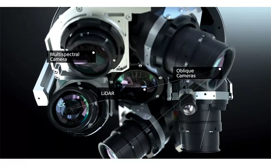
Leica’s new CityMapper combines oblique imaging cameras, LiDAR and a multispectral camera into one package that can be mounted on a plane and used to increase the data collected in a flyover.
Stockholm-based Hexagon AB has announced the commercial release of its enterprise-level construction-management cloud service, which it calls SMART Build.
Hexagon’s construction-management service is meant to manage the building process, from preconstruction to building life-cycle management.
“To move the needle on overall project performance, we have to connect siloed information,” says Marc Goldman, vice president of AEC and BIM product management for Hexagon. The company introduced the service at its annual conference, which brought 2,000 attendees from around the world to Anaheim, Calif., June 13-16.
SMART Build makes all project information available in the cloud and accessible through a browser-based software as a service. BIM-to-field capabilities allow users to interact with the building model from anywhere as well as add construction layout points to the model, says Goldman. Users can push the layout points into an icon-controlled total station on the job site. The total station laser-positions those points on the site; then, during quality check, it captures the points and sends them into the cloud. Goldman says issues with the scanned layout and the model are captured and reported so users can act on the discrepancy right away. “With this process and SMART Build’s digital layout capabilities, survey crews can lay out 100 points in an hour, as opposed to the industry average of 100 points a day,” he adds.
The available version of SMART Build doesn’t allow for offline use, but the second version, coming out at the end of the year, will have that capability.
One of Hexagon’s subsidiaries, Leica Geosystems announced many new releases, including the CityMapper, which is a reality-capture device that marries oblique imaging with LiDAR.
Oblique imaging takes aerial photos from 40° to 50° relative to the ground. With four oblique cameras at disparate angles, a multispectral camera and a LiDAR unit—all mounted onto CityMapper—the level of detail that can be mapped out in a single flyover increases.
Another Leica release is the LS15 digital level, which is the only digital level on the market equipped with a camera, according to Falko Henning, product manager for digital levels at Leica Geosystems. The level offers 0.2-millimeter accuracy, he adds
Looking for quick answers on construction and engineering topics?
Try Ask ENR, our new smart AI search tool.
Ask ENR →


