Tennessee Rockslides Close Interstate 75 in Both Directions
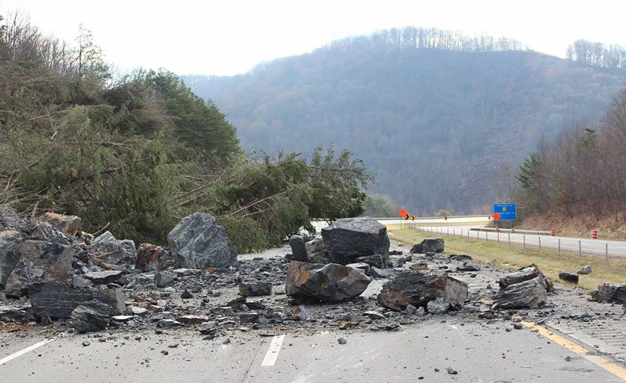
Rock and Roll Series of slides in late February near Pioneer, Tenn., spared lives but closed a section of I-75. An emergency repair contract worth $2.9 million will keep contractors busy until mid-April. Courtesy TDOT
Crews are removing rock and debris from the Feb. 26-29 rockslides that closed Interstate 75 in both directions in east Tennessee. This work will help to stabilize the mountain.
The plan is to stabilize the slope and flatten it slightly to prevent further slides, said Mark Nagi, Tennessee Dept. of Transportation spokesman. The initial slides near Pioneer, Tenn., were Feb. 26-29. There was still movement in the area March 5.
The first step is to remove an estimated 80,000 cu yd of rock and rubble from the top of the slope and create a bench to catch other rock, said Allen Blalock, vice president of Charles Blalock & Sons Inc., Sevierville, Tenn.,which has the $2.9-million emergency contract for stabilization and repairs.
“We’re still trying to get [the area] staked,” he said, adding that the project is “evolving” as crews work the mountain.
The project must contend with the Tennessee Valley Authority power transmission lines that run across the top of the hill. The agency has shut off the lines and is working with TDOT, Blalock said.
The slope area is about 120 ft high and 500 ft to 600 ft wide, though it is shorter at each side. “The material remaining above the bench is essentially a high wall, similar to what is created during surface mining or open-pit mining,” Nagi said.
“This nearly vertical slope will not remain stable indefinitely, and we plan to flatten the slope to a 45° angle, or 1:1 slope ratio,” he said.
Looking for quick answers on construction and engineering topics?
Try Ask ENR, our new smart AI search tool.
Ask ENR →
That proposed slope “likely will not require the construction of a wall or barrier at the base of the slope,” Nagi said.
Next would come wire mesh, anchored with No. 10-grade bars, with an average length of about 50 ft. The mesh is 3-millimeter high-tensile wire, and the 1.27-in. bars hold 100,000 psi.
Shotcrete is sometimes a solution, but David Barker, TDOT geotechnical engineer, said the agency prefers to use anchored wire mesh combined with vegetation, using erosion-control matting reinforced with wire.
The slide closed I-75 between mile marker 134, near Caryville, Tenn., and mile marker 160, near Jellico, Tenn.
The cause of the slides still hasn’t been determined, though Barker calls it “an interesting failure.”
The rock is flat-lining shale, which is porous and known for its ability to hold moisture; water can accumulate under it, he said. “Usually, when you have a failure, water is involved,” he noted, though there had not been heavy rain in the days before the slide. Barker said he will “look for signs of groundwater coming out of the new slope, if, indeed, there is groundwater there.”
Robert Hatcher, professor of earth and planetary sciences at the University of Tennessee-Knoxville, cited the effects of the mountains’ rain-freeze-thaw cycle. The highway was built in the mid-1960s, but, “all of a sudden, you have a slide,” he observed.
“Something had to trigger it, and my guess is water—the rainfall-snow-freeze-thaw cycles,” he said. As a little water seeps into cracks each year, enough accumulates to cause a slide, he added.
Rockslides can’t be prevented, but they can be mitigated, said Ali Maher, director of Rutgers University’s Center for Advanced Infrastructure and Transportation and a member of the American Society of Engineers’ soil improvement committee.
There are two classes of mitigation, he said. “Passive mitigation is more expensive: You build a wall, protect the slope and catch debris that tumbles down.”
Active mitigation involves identifying the main joints or openings in rock, then securing loose rock “to the more intact layer underneath,” sometimes using shotcrete to hold it all together.
“What I see here is the contractor is being conservative,” using anchored wire mesh to hold the slope in place, he said.
Average daily traffic in the area is more than 28,000 vehicles per day, but the number swells each year due to spring-breakers traveling to Florida.
The timetable calls for southbound lanes to open before March 17, one northbound lane to open by March 24 and the entire project to be completed by April 15.


