Laser Links to CAD in the Field 2/7/2005
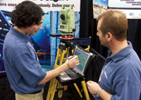 |
| Laser Direct. Delisle (left) targets survey device directly from CAD. (Photo by Tom Sawyer for ENR) |
Gabriel Delisle stands beside a Leica Total Station. A laptop PC fitted to its tripod displays a 3D CAD model. Delisle clicks a point at the top of a column on screen and the surveying device instantly rotates. The red tag of its laser nails the top of a column 80 ft away.
"It’s bi-directional," Delisle remarks, meaning that users can navigate in a CAD image to locate features on a structure, or use the laser to tag points and apply those coordinates to build a CAD model or drawing in the field. Delisle is a software developer at fieldDesigner, Inc., the Montreal-based creator of the CAD/total station linkage.
The software works within AutoCAD 2002 and is sold with it, although it can export data into other CAD programs as well. Using a library, points can be related into 3D representations. Three points on a pipe establishes curvature; two more establishes length, and the software delivers a 3D pipe to the screen.
"You’re actually surveying right inside the AutoCAD session," says Michael Frecks, president of 3D Services and Solutions, an Elkhorn, Neb.-based surveying and visualization consultant. "It’s like surveying in the virtual world," he says.
Frecks has been using the system, introduced at the World of Concrete in Las Vegas last month, in trials for about a year. "I love it," he says. "I have not seen any other product that can accomplish these things."
"We developed it in our company to eliminate revisits," says Stéphane Arsenault, fieldDesigner president. He says his 40-year-old firm was fed up with converting survey data in the office, only to have to send crews back out to correct errors and pick up missing information. He says the system also is great for checking construction accuracy against models or plans. "If something is off, you will know it right then," he says. Frecks adds that the device also is easy to orient. "You just pick up a few points," he says. "Control point problems virtually vanish."
The basic package has software, tripod, dolly and PC rack. The company says it can deliver many configurations and options, including links to GPS and wireless hand-held measuring devices.


