Levee and Floodwall Load Test Is Handled With Extreme Care
...cofferdam is in direct hydraulic connection within the sand,” Nazarko says. The Corps’ original concept was to focus only on the crack-failure scenario, but the decision was made to include the second-phase test in conjunction with the levee-board partners and the review team, Nazarco says.
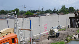
The instrumentation contractor, URS Corp., San Francisco, in late July installed a redundant Automated Data Acquisition System to monitor for soil or I-wall movement and water seepage. The system includes piezometers, tilt meters, inclinometers, prisms and Leica Geosystems Total Stations, says Nazarko. The robotic total station sends a beam of light every 20 or 30 seconds to each of forty-two prisms. The prisms are in line with the tilt meters positioned on the wall and mounted at the levee base, toe, top and midpoint. “It performs well in harsh conditions,” Conroy says. “It takes wonderful measurements in 104º,” says Conroy. “It works in the rain, and I don’t have to feed it, water it or give it Gatorade.” Shooting multiple targets would also be difficult for a person. “This is accurate and can perform 24 hours a day, so we get results faster,” he says.
 Angelle Bergeron/ENR Target elevations on the canal side are near roof levels on other side. |
Three inclinometers—located at the canal-side crest, the protected-side crest and on the mid-slope of the protected side—measure earth movement. Piezometers are placed to measure water pressure at the critical juncture between the marsh layer and sand strata.
Tilt meters have also been placed at varying heights on the floodwall. The Corps is using Geo-Con tilt meters, which are well-proven in harsh field conditions, Conroy says. It is also testing a new design by Sensa Metrics, which measures low-level activity and operates on D-cell batteries. “It’s in a very dormant state, like almost asleep, but with only one eye open. When some movement occurs it becomes fully awake and starts transmitting data wirelessly,” Conroy says.
For this test, the Sensa Metrics is hard-wired to transmit its data. Its performance will be benchmarked against the long-used Geo-Con meters. If it performs well, it may later be used for wireless monitoring in a full-canal load test or during storm events, Nazarko says.
A bundle of wires connects the instrumentation to a tiny trailer, where URS, Leica and Sensa-Metrics representatives sort the data from 6 a.m. to 7:30 p.m. “Every 15 minutes we wrap up a set of data aand send it via broadband to a trailer about 1,000 ft up the canal,” Nazarko says. The other trailer is the temporary home of a technical review team that analyzes the information, only about 15 minutes behind the real-time data.
The technical review team includes IPET member Tom Brandon, a professor from Virginia Tech; Noah Vroman, who is with the Corp’s Engineering Research and Development Center in Vicksburg, Miss.; Neil Schwanz, a geotechnical engineer from the Corps’ St. Paul District; Ray Martin, an independent consultant; and Robert Bachus, with Geo Syntec, Atlanta.
The data is being collected around the clock, but the crew has not been working 24/7 primarily because the Corps promised surrounding community residents that it would not exceed safe-water limits in the cofferdam overnight. That is only one of a list of concessions the Corps made to ensure safety and peace of mind for nearby residents.
The test was originally scheduled for completion by June 1, but the Southeast Louisiana Flood Protection Authority-East refused to grant the Corps right of entry to the site until it submitted the test and safety plan for peer review.
“This is a complicated, technical situation, but on the face value, the Corps is putting water on the floodwall,” Nazarko says. “You can imagine how that affects people who have been through Katrina. We want to assure them why we are here, what we are doing and the safety precautions we are taking.”
Safety measures include the wing-wall cofferdam design for an additional buffer and a quick-release sluice gate in the dam. “They’ve got a crane positioned in the canal on flexifloats,” Nazarko says. “You can hear engines idling because we are prepared to pull the sluice gate at any time.”
 Angelle Bergeron/ENR Data is processed for peer review on site, in real time. |
There are also two, 500-gallon-per-minute pumps and one 250-gpm pump on a platform over the cofferdam to remove the water if it exceeds “test termination” thresholds. There is also a land-side port-a-dam for secondary containment in the event of a failure. Nazarko refers to it as “double suspenders on a double-belted pair of pants.”
By Aug. 24, the Corps had held 7 ft in the cofferdam and reached equilibrium within desired threshold ranges, Nazarko says. “I can’t conjecture as to whether or not the SWE will be increased,” he says, adding, “My charge was to execute this test safely.”
Although the scientists have yet to decide whether the SWE may be increased, they say the Corps has already learned valuable lessons from this project, including how to inform the public and stakeholders and how to sift the data and conduct real-time analysis, says says Lt. Col. Murray Starkel, deputy commander of the New Orleans District. “We are already using the results in California,” he says. “What’s been shared so far are the underlying crack results and the underlying assumption of the entire static load on the system.”
The results of this test will also guide Corps specifications for future levee and floodwall construction, Nazarko adds. The second phase of the test, scheduled for three days, began Aug. 26.


