Power Hazard Forecasting Tool Gives New Orleans New Map
| + click to enlarge |
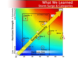 Storm Surge and Hurricane Categories -- The new research defines the way storm surge intensity is correlated to hurricane wind speed and atmospheric pressure, and the diameter of the storm. According to Bruce Ebersole, the hurricane surge and wave analysis co-leader on IPET, Hurricane Camille, a Category 5 hurricane with extremely low pressure and high wind speeds but a relatively small, 25-mile diameter, had a 24.6 ft (7.49-meter) storm surge. Katrina, with less intense Category 3 winds at landfall, nevertheless was twice the diameter and roared ashore with a 28 ft (8.53 meter) surge, based on the maximum reliable high water marks found. (Image: Army Corps of Engineers) |
Sections of New Orleans remain flood-prone, but at least now residents can see where waters are most likely to rise after a storm.
Reconstruction planners and citizens of New Orleans received a powerful new risk assessment tool June 20 to guide their decisions. It is a flood analysis system developed by scientists working for the U.S. Army Corps of Engineers that has evolved from their growing understanding of the power of hurricanes and the performance of engineered storm defenses. And while its first application is to floods in New Orleans, the scientists say it is designed to be applicable to assessing the probable performance of natural hazard defenses of any kind, anywhere.
The product has been developed out of work of the Interagency Performance Evaluation Task Force, which was commissioned in the aftermath of Hurricane Katrina by General Carl A. Strock, former chief of the Corps of Engineers. Strock convened the scientists to find out why the storm caused such destruction, and how the system that was in place to protect the city when it hit, performed. The Risk & Reliability report, released this week at the New Orleans District of the U.S. Army Corps of Engineers, is the final volume of the IPET project.
"This will be an unbelievable tool for understanding risk when people are deciding where and how to build," says Donald Powell, federal coordinator of Gulf Coast Rebuilding. Powell is tasked with developing a long-term rebuilding plan for the region in the aftermath of Hurricanes Katrina, Rita and Wilma, and with coordinating the federal efforts to helping state and local officials reach consensus on their vision for the reconstruction.
The risk assessment provides information on the performance and vulnerability of the hurricane protection system in the 37 sub-basin areas of southeast Louisiana under a wide range of possible future hurricanes, ranging from 50-year to 5,000-year plus storms. Using a unique modeling tool developed by IPET and the Corps, residents are now able to view maps of their neighborhoods, overlaid with color coding that demonstrates potential inundation levels that existed pre-Katrina, and again on June 1, 2007, with improvements to the protection system since the storm.
Later this summer, the Corps promises to deliver the models that will allow residents to see risk analysis projections when additional upgrades to a 100-year level of protection are complete.
"We now have a risk assessment for our area that no one else in the country has right now," says Karen Durham-Aguilera, director of Task Force Hope in Louisiana, which is responsible for overseeing the $5.7 billion long-term planning and hurricane protection system work in Southeast Louisiana. "What an incredible advantage to have this information that no other area of the country has."
The risk analysis tools may be tailored to address specific concerns, such as overall risk by sub-basin, risk for specific features in the hurricane protection system (gates, levee transitions, etc.), and depth of flooding that is accurate to plus or minus one foot, says Lt. Col. David Berczek, the Corps' leader on risk analysis. Based on computer-generated models of 25- to 5,000-year storms following 152 different tracks and hydrographs at 138 different locations, the IPET model is a more accurate gauge for determining the intensity and effects of future storms than the far less sophisticated Category system, says Ed Link, IPET project director.
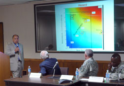 : Angelle Bergeron/ENR Ed Link, director of the study that yielded the risk modeling tools, presents the new product to the public in New Orleans June 20. |
The model provides an invaluable tool that will guide future Corps design and construction, as well as city planning and individual residents' personal decisions, says Durham-Aguilera.
"This is a prototype risk model, something that works now but will be refined over time," says Lt. Gen. Robert Van Antwerp, Corps commander and chief of engineers. "We will use it, learn from it as we go, and see if we can apply it to other areas. It's fitting that the people in southeast Louisiana will be first, but I can't help but dream that everyone in the rest of the country who has a levee or any feature that protects them won't benefit from this."
The Corps is "talking about" where to next apply the model, but no particular schedule has been mapped out to date, Van Antwerp says. "We are already using the technology, but don't have a particular rollout date for other areas," he says.
It is important to explore the probability of applying the tool to other locales, says Larry Roth, deputy executive director of the American Society of Civil Engineers. Such a tool would provide a valuable resource for the Sacramento, Calif. area in particular, which has risk from both seismic activity and levee failures due to river flooding, Roth says.
"I'm on one of the review panels for the Sacramento system and the first question I asked is if they know their levee heights�and they didn't," says Robert Gilbert, a civil engineering professor at the University of Texas, Austin, and one of the risk experts on the IPET external review panel. "What happened here is a benefit to them because it's a wakeup call."
Applying the model to Sacramento's seismic activity and river flooding would be very interesting, Roth says. "A hurricane is a severe hazard, but it is one hazard."
The tool was developed to be generic so it could be applied to a variety of risks, Link says. "This is a tool that we will learn to use more effectively and efficiently, and there will be a national capability that will be evolved from this."


