Web-based System Tracks Work and Keeps It on Track Projects
Officials in Jacksonville, Fla., had two concerns when the city embarked on a $1-billion construction program when another $3 billion of work from other agencies also was getting under way: Would there be enough engineering and construction capacity to handle all of the projects and could they be coordinated for better efficiency?
The 10-year Better Jacksonville program, approved by voters in September 2000, was a complex undertaking. But in the fast-growing northern Florida city, the Florida Dept. of Transportation, Jacksonville Transit Authority, the local power authority and some private corporations also were starting significant work.
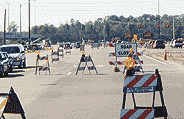 |
| AT WORK Growing Jacksonville, Fla., can keep $4 billion of projects out of each other's way in next 10 years. (Photo courtesy of HDR) |
The transit agency has $1.5 billion in construction planned, while Florida DOT has nearly $2 billion, including major intersections along Interstate-95, says Suraya Teeple, FDOT urban planning administrator in Jacksonville. Utility firms have many maintenance and capital projects planned and under way.
"With this many players and activities, it's easy to lose sight of the big picture," says Derek Morse, transit authority executive director. Converging information related to roads and highways citywide would encourage project linkups and help avoid construction conflicts, Teeple says.
To create such a clearinghouse, authorities turned to consultant HDR, Omaha, a transit authority subcontractor. "Any one of the entities involved can bring the city to its knees traffic-wise," says Tom Sanders, senior vice president. HDR developed a simple solution�a geographic information system that overlays projects planned by participating agencies over the next 10 years. Each agency's work is color-coded.
HDR modified the ArcIMS Internet mapping tool to incorporate information such as the type and location of each project and its design and construction schedule. "It takes a casual user's perspective," says Sanders.
The software allows each agency to query the Internet-based system to search for pertinent information over time. For example, a planned sewer construction project could be accelerated to become part of a road construction job to keep the road from being torn up twice. "Agencies can use this to adjust schedules accordingly," says Ray Reissner, HDR senior project manager. Agency schedule changes can be tracked. Most agencies had detailed maps available, but there were no intelligent links between graphics, adds Reissner. HDR kept corresponding as simple as possible. "We weren't interested in putting all the information available on the system, but data can be added as it expands," he says.
The system provides a universal, round-the-clock location and tool for users to obtain information, even when they lack specialized software or computer skills, says Reissner. It ensures that city streets are torn up just once during the Better Jacksonville program, says Kendra Porter, HDR national e-commerce director. This could become critical for a city in a hurricane zone that must do evacuation planning. "Without [the system], we could collectively but innocently affect evacuation routes," she says.
The system was installed earlier this year at an initial cost of $40,000. It will cost up to $20,000 a year to maintain the data. "We're already seeing the benefits," says the transit authority's Morse. "People are having conversations they would not have had without this tool."