Katrina Analysis Has Designers Building Faster and Smarter
| + click to view a map of ongoing work | |
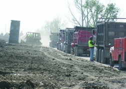
) | The Jobsite: 169 Miles of Damage Repair |
ERDC scientists are preparing to repeat the experiment. At 81 RPM, at the end of a 6.5-m centrifuge boom, the weight of the 1,000-lb model and box will grow 50 times, to 50,000 lb. At Rensselaer, it took less than six minutes for the I-wall to fail, revealing a design flaw that instantly indicted all 56 miles of similarly built wall in the system.
) |
| Heavy. Braced T-walls are replacing I-walls on Inner Harbor Navigation Canal, adding strength. (Illustration by Nancy Soulliard for ENR) |
Contractors now are either replacing the I-walls with heavily braced T-walls or building storm gates to block off outflow canals in Orleans Parish to prevent another storm surge from coming in.
The T-walls are massively braced. A 4,000-ft section along the Inner Harbor Navigation Canal, an area where scouring on the back side during overtopping apparently triggered collapse, is being replaced with T-walls locked down by 2,240 70-ft-long H-piles angled out in two directions, 5 ft 6 in. on center, according to Stuart S. Waits, Corps IHNC project manager.
IPET's inquest was broken down into nine critical and coordinated investigations, but the starting point was the validation of an elevation baseline for southeast Louisiana. The Corps and NOAA's National Geodetic Survey were already working on that before Katrina. They accelerated the effort using the most current technology, establishing a new datum in October. That led to revelations that large parts of the system were well below design elevation, due to sea level rise, survey or design errors, or subsidence—in some cases of several feet. The Inner Harbor Navigation Canal's floodwalls, for example, were 2.7 ft lower, relative to sea level, than previously believed.
Applying revised elevations to the storm surge and wave actions predicted by IPET's computer modeling, researchers found large expanses of outer protection levees were overtopped by a fast, solid flow of water for hours during the height of the storm.
"It wasn't even close," says Donald T. Resio, a senior ERDC research scientist. "Obviously, if you have overtopping, you're in trouble," he says. "Scour is a function of velocity and time, and the effects of waves becomes critical. On the backside of the levees during the overwash they had speeds of 15, 20, 25 feet per second. It was almost like a freefall."
 |
| Piles. Supplies are fine, but prices for good quality clay have kept increasing. (Photo by Tom Sawyer for ENR) |
One early realization is that armoring the backside of levees, particularly in transition zones and areas of special vulnerability to overtopping, could greatly improve system survivability. "We're getting a lot of good ideas on how to build the future system," he says. "I hope it would be of extreme interest to anybody in coastal areas. There's so much that we need to learn, particularly since sea level is rising. We're certainly seeing a lot of powerful storms, and a one-foot-per-century sea level rise is not going to stop."
Although some areas, like Florida, are obviously exposed, others, like the upper East Coast, are probably more at risk than people think. The fast-moving "1938 Storm" dragged in the highest storm surge ever recorded in the Northeast. Estimates put it at 16 ft above mean sea level on Long Island and Rhode Island and 12 ft in eastern Connecticut. Such an event today could have enormous consequences for infrastructure like New York City's subway system.
"All this will be used in the future," says Risio. "We're learning all the factors that make a difference. We're trying to give the right answer." months, everywhere at once.
"F or each parish we put together a multifunctional team," says Setliff. "We had real estate people, environmental people and structural and civil engineers. Each team has a leader who can make decisions very quickly...the schedule here is of paramount importance." He says that while management has been "intensive," the philosophy is to treat contractors like partners, track their progress closely, monitor constantly and meet frequently, but only "manage by exception—if they start to get off track."
"Our philosophy early on was that we wanted to ensure victory back in February, instead of prevent defeat in May. Probably when people look back at this it will be seen as the wave of the future," Setliff says.
"None of these jobs has worked out the way any of us expected—labor, equipment, so many unknowns," says Wayne Ledet, one of the owners of LL&G Construction, Houma, La., in his job trailer at the Bayou Bienvenue Flood Control Structure repair site. James Drinkwater, one of Ledet's superintendents on another flood control repair, says maintaining a labor force to keep pace with the schedule is his biggest challenge. "I could use five more welders today, but I can't get them," he says.
Everything is at a premium. "We had to stockpile material in order to have enough," adds Ledet. "That's one thing I told the Corps: ÔYou've got to allow us to stockpile if we're going to get this job done.'" Plugging the 310 ft of breaches at Bayou Bienvenue took 40,000 tons of rock, 50,000 yd of sand and 8,000 yd of clay. "Clay before the storm was $15 to $25 per yard; now it's $45," Ledet says.
Ledet strongly supports the Corps' approach to the work. He says he has built flood control structures and pump stations for 15 years for both the Corps and local governments. Despite the widespread failures throughout the system, he still feels consolidating all levee construction, operation and maintenance under the Corps is the only way to go. "Locals don't understand compaction and quality control," Ledet says. "If they take the levee work from the Corps...it will be all about locals and buddies."
 |
| Relentless. constractor crews set jacket for temporary canal gate. (Photo courtesy of Boh Brothers Construction) |
Construction innovations are driven by rapidly improving understanding of the engineering requirements for building survivable hurricane resistant systems. A $20-million, crash research campaign has been under way since the storm, also under sponsorship and direction of the Corps and centered around its Engineering Research and Development Center in Vicksburg, Miss.
Called the Interagency Performance Evaluation Review Taskforce, the project has pulled together a team of 150 scientists and engineers who are analyzing the storm and the behavior of the flood protection system during it. Their preliminary results are leading to significant changes in design and construction.
"It's a high performance team," says the task force's technical director, John J. Jaeger. Half of the project leaders, including Jaeger, are drawn from experts within the Corps, and half from federal agencies or academia.
They are trying to answer questions about how the system's many structures were designed and built, and what condition they were in when Katrina came ashore. The storm, with its winds, waves and surge, has been modeled with three separate programs on a Cray XT3 super computer with 256 parallel processors, using meteorological data from the National Hurricane Center and other sources. The model covers the entire region and is based on 377,815 data points solved in one-second time steps, over six days. It takes 75 minutes for the Cray to run the storm, says Bruce Ebersole, chief of the ERDC flood and storm protection division.
Ebersole says factors in the height of the surge were wind speed and direction and the shape of the land masses and sea bottom. The computer models show how those variables morphed with the movement and changing intensity of the storm, and reveal how serious the set-up for disaster was. "Katrina's winds traveled across the continental shelf and ran against the large bays, piling up the water well ahead of the storm," says Ebersole. "A day-and-a-half out, the water was already up three or four feet. The wetlands were inundated."
Wave behavior also changed dramatically as the storm neared land. The model has raised eyebrows by demonstrating how long-period waves, "which convey a lot more energy at a given point and can give a 75% greater run-up," began to pile up against the levees lining the Mississippi River Gulf Outlet to the east of the city, he says.
"This is the most rigorous analysis for hurricane winds [the National Oceanic and Atmospheric Administration] has ever done," Ebersole says. Engineers have gone into the field to retrieve hard evidence such as eyewitness accounts, photographs, stopped clocks, and carefully surveyed high-water marks. By combining those data points with the computer model they have created what they believe is a 95% accurate simulation of how the storm created the surge that sank New Orleans.
Better, more survivable instrumentation would help but there are few that can survive a hurricane, Ebersole says.
Almost every instrument in Katrina's path failed before the storm peaked at each location. One of NOAA's 10-meter-dia, saucer-shaped instrument buoys flipped, although another buoy, well offshore in 900 ft of water, reported a maximum wave height of 55 ft. Ebersole says that is the highest ever reported on the U.S. Continental Shelf. Maximum wave height is an average of the highest 13 waves.
Surge modeling has predicted phenomenon that correlates closely with data investigators have gleaned from the wreckage of New Orleans. The findings are analyzed and applied as force data to study.