Software Automatically Translates Some Point Cloud Data to CAD Drawings
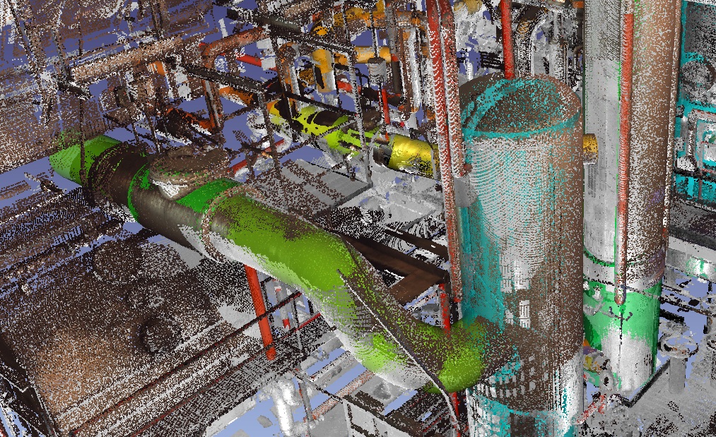
Automating 3D model creation from laser point cloud data has been a dream for anyone who has modeled millions of points into 3D objects. One company now has released improved software that automatically recognizes flat surfaces, edges and cylindrical objects from point cloud data.
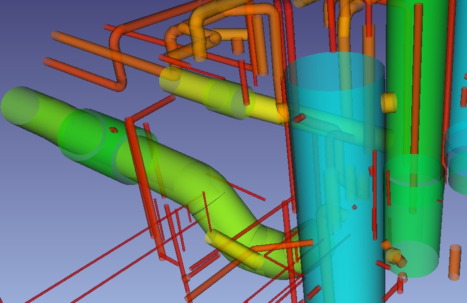
EdgeWise Plant 2.0 from ClearEdge 3D Inc., Warrenton, Va., lessens the need to manually trace objects such as pipes, walls and joints. It uses algorithms to identify surfaces among millions of points of data collected by light detecting and ranging devices (LiDAR), such as laser scanners. It discards irrelevant data and extracts geometry automatically.
"Automation is the Holy Grail of LiDAR,” says Mark Klusza, an engineer and self-described "entrepreneur in residence" at Global Infrastructure Services LP, Berkley, Calif., a technology development company with a background in laser scanning but no financial interest in ClearEdge. “The software drastically cuts hours and hours of time," Klusza adds.
“It gives you a good starting point,” says Kevin Grover, a ClearEdge user and chief of the geomatics practice at Stantec Geomatics Ltd., Edmonton, Canada. He says the program gets rid of a lot of irrelevant data by finding and extrapolating lines and objects.
Grover says the program is easy to learn and "very robust when finding cylinders," but adds that "it misses quite a few objects." Having used other programs designed for the same purpose—including AutoCAD’s Cubit and Leica's Cyclone—he says, "The biggest difference between EdgeWise and these programs is it requires no user interaction." Both Cubit and Cyclone need some type of interaction to model pipes. Grover says, "Automation is why I use EdgeWise. We’ve dropped 50% of our modeling time. We’re saving hours of labor.”
Klusza, who was recognized as an ENR Newsmaker in 2004 for his work developing software to integrate laser- scan data into CAD-ready files, says there’s nothing better than the human eye at detecting shapes in point clouds. “Quality control is always necessary after scanning a room, but [ClearEdge software] usually gets it right.” Klusza says reliability has always been a problem when extracting objects from LiDAR data because scanners can compile only the data that their lasers can see. For example, scanners usually miss the tops of ceiling pipes when scanning from the floor. ClearEdge's algorithms recognize the pipe as a cylinder and extrapolate its full dimensions.
With a background in airborne LiDAR data, Kevin Williams is the lead scientist and co-founder of ClearEdge Inc. It took him four years to build the core algorithm upon which the program is based.
“I tend to be a lazy person at heart, so the idea of doing these things manually is terrifying to me,” says Williams. “Push one big button and our program typically gives you 60% to 80% of the pipes scanned in a room.”
Kulsza says the program's biggest benefit is that it can model most of a room within the first day. Though it’s not a perfect model, the immediacy of the data is what matters, he says. However, Kulsza expressed dissatisfaction with the cost structure, which is priced per scan, when complex projects may involve thousands of scans. The base price for using ClearEdge is "about $30 dollars a scan," which compares to about $100 to manually model the same data, Williams says.

