Researchers Want To Take the Legwork Out of Highway Asset Maintenance
Geospatial mapping and object- recognition algorithms being developed by researchers in Virginia may soon cut the cost of managing assets like signs and guardrails along highways.
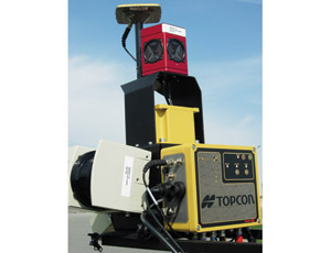
Jesus de la Garza, a civil engineering professor at Virginia Polytechnic Institute and State University Center for Highway Asset Management Programs (CHAMPS), Blacksburg, Va., expects to start phase two of his research this fall using a TopCon IP-S2 geographic information system—a combination of a Global Positioning System and a 360� remote-imaging scanner—which de la Garza believes can help automate highway asset assessments.
Since 2002, CHAMPS has been working with the Virginia Dept. of Transportation to help it implement, manage and improve its highway asset maintenance program.
“They have made a 180� shift with their highway maintenance contractors, moving from a traditional, piecemeal-based process to a performance-based process,” de la Garza says.
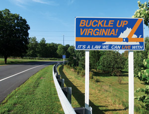
Now VDOT no longer tells contractors when, where or how to maintain highways, it simply specifies the standards to maintain. Then, through CHAMPS, VDOT uses an advanced random sampling process that the program created to audit contractor performance. It samples the condition of assets, such as cross pipes, paved and unpaved ditches, signs, pavement markings, guardrails, guardrail terminals and unpaved shoulders.
Blacksburg, Va.-based subcontractor Anderson Associates was hired by CHAMPS to monitor the 13 regions assigned to the state program. Currently, Anderson’s workers walk down highways and check for damage to road signs, guardrails and other VDOT assets.
The process is expensive and labor-intensive and accounts for up to 80% of the maintenance program’s cost. Reducing that cost is the goal of the research.
In phase one, researchers established the asset recording capabilities of an IP-S2 geographic information system device, which was loaned to CHAMPS by Topcon for the project.
Richard Rybka, Topcon mobile mapping specialist, says the IP-S2 uses three redundant technologies to establish its exact position: a Global Navigation Satellite System, an Inertial Measurement Unit and devices that calculate distance by tracking wheel rotations. The IP-S2 simultaneously captures 360� video and light detection and ranging, or LiDAR, data through sensors that have an effective range of 30 meters.
“Essentially, the laser scanners are collecting literally millions of points that let you superimpose the picture onto a point cloud,” says Rybka. “The hardware is one component, the analysis is another.”
CHAMPS conducted the phase-one tests on a 2.2–mile closed-highway research center called the Smart Road. It checked the performance of a truck-mounted IP-S2 and matched data that the device gathered to assets known to be around it.
The results showed the IP-S2 could read guardrails, road signs and other uniform assets in its line of sight. It could not read reflective markers or paved ditches.
One of de la Garza’s students, Berk Uslu, says that, when driving in the center of the road, the IP-S2’s field of vision extends 6.5 feet beyond the road’s edge.
The second phase is to develop algorithms to recognize and flag the assets the IP-S2 records, so software can recognize and assess them without human review.
Uslu says that once the assets are recognized, they will either pass or fail the scanning process. An intact road sign with proper reflection and a clear surface area will pass. A sign covered by mud or riddled with bullet holes will fail and automatically be flagged. The device should even be able to pick up graffiti or foliage—anything that obstructs 15% to 20% of the sign’s surface area.
Dimitris Sideris, a researcher on the project, says, “It all depends on the algorithms now. The hardware is there.”


