Science
Study Finds East Coast Infrastructure Is Sinking Along With the Land
Subsidence is occurring faster than expected, say scientists
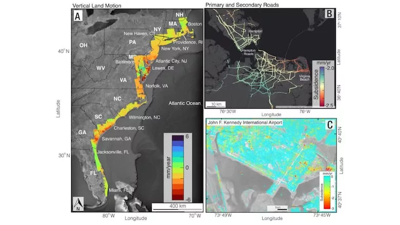
A spatial map of vertical land motion of the East Coast (left panel); primary, secondary, and interstate roads on Hampton Roads, Norfolk, and Virginia Beach, Va., (top right panel); and John F. Kennedy International Airport in New York City (bottom right panel). The yellow, orange and red areas on these maps denote areas of sinking.
Images courtesy of Virginia Tech University/Leonard Ohenhen
A team of Virginia Tech scientists says portions of the East Coast—particularly densely populated coastal areas in the Mid-Atlantic region—are sinking faster than originally believed, putting at risk not only wetlands and agricultural areas, but also the structural integrity of roads, airports, dams and other types of built infrastructure.
The researchers, from the university's Earth Observation and Innovation lab, concluded that more than half of the infrastructure in cities like New York, Baltimore and Norfolk, Va., is located in areas that sank between 1 mm and 2 mm annually.
But while up to 70% of East Coast infrastructure is located on land experiencing some level of subsidence, less than 10% is on land sinking more than 3 mm yearly. However, in some areas, such as Charleston, S.C., the ground is subsiding by almost 4 mm annually, where flooding is a real problem, says Leonard Ohenhen, a Virginia Tech geophysicist and study co-author.
“Subsidence is a pernicious, highly localized and often overlooked problem in comparison to global sea level rise, but it's a major factor that explains why water levels are rising in many part of the eastern United States,” he says.
The research, funded by the National Aeronautics and Space Administration, points to the need for engineers, builders and urban planners to place greater focus on the dual conundrum posed by land that is sinking while sea levels are also rising, researchers said.
“Our analysis has far-reaching implications for community and infrastructure resilience planning, emphasizing the need for a targeted approach in transitioning from reactive to proactive hazard mitigation strategies in the era of climate change,” authors concluded in PNAS Nexus, a National Academies of Science publication.
Insights From Satellite Data
Subsidence occurs when land begins to sink as a result of aggressive groundwater extraction, as well as construction of dams and levees that block sediment from replenishing land along rivers and streams. The result can lead to increased flooding in areas already grappling with rising sea levels.
The research team analyzed U.S. Geological Service satellite data and ground-based GPS sensors to map the vertical and horizontal motion of land from Florida to New England between 2007 and 2020, and also evaluated the extent to which infrastructure in these areas could be at risk.
Researchers found that along the East Coast, between 77% and 99% of interstate highways, 81% to 99% of railway systems, and more than 800,000 properties are exposed to risks from subsidence. This is a particular challenge in low-lying areas like Hampton Roads, Va., and Norfolk, Va., which already have more than 2 mm of subsidence annually and as well as frequent flooding of transportation infrastructure, the study authors reported.
Land that sinks evenly poses less of a risk than land sinking unevenly, the authors wrote.
“Unmitigated, such subsidence may slowly but surely compromise the structural integrity of urban infrastructure and exacerbate other hazards (e.g. flooding), contributing to socioeconomic losses,” the study says. “Beyond the direct impacts, subsidence in coastal zones is a major driver of current and future hazards, amplifying the impacts of climate change-driven global sea level rise. Consequently, understanding the impact of continuous subsidence in coastal zones is essential in transitioning from reactive to proactive climate change mitigation strategies.”


