Drone-Mounted LiDAR Brings Fresh Data to State DOTs
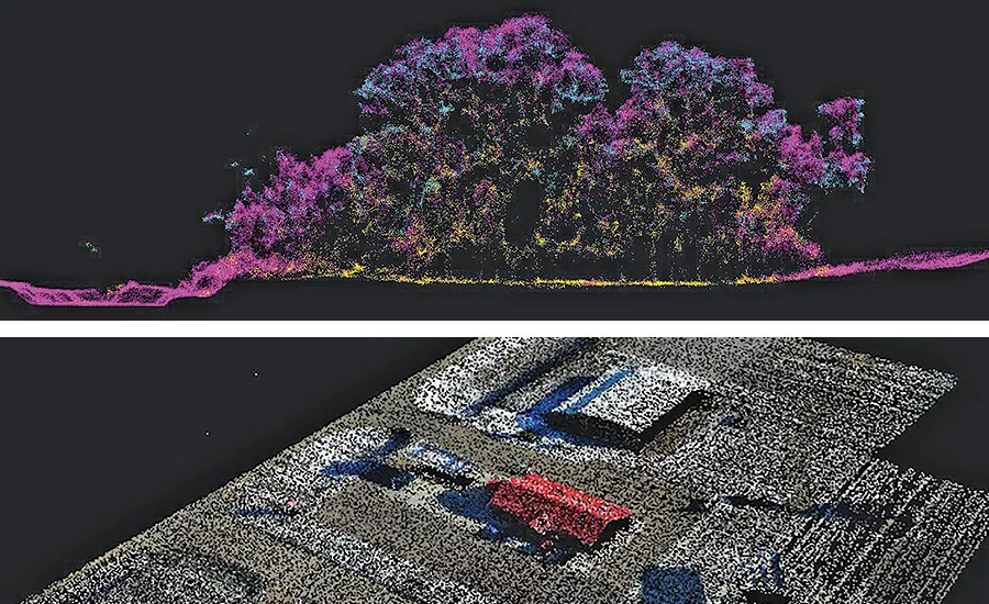
LiDAR is able to penetrate dense vegetation for a clearer view of ground conditions.
Image courtesy NDDOT
In recent years contractors have seen the advantages of employing light detection and ranging (LiDAR) technology with unmanned aerial systems (UAS), also known as drones. State transportation departments are now using these systems and integrating them into their procedures.
“This is another tool in the toolbox,” says Derek Pfeifer, program manager with North Dakota Dept. of Transportation’s (NDDOT) Design Division. “We have found the technology is very good at examining small areas such as intersections and in areas that have significant ground cover the LiDAR can see through.” Over the past year, NDDOT has built a UAS program in cooperation with the FAA. Integrating LiDAR technology has been a component of that initiative. NDDOT has found uses for UAS LiDAR with bridge inspections, intersection surveys and excavation estimates.
LiDAR-equipped UAS are effective in surveying areas with uneven terrain difficult to survey traditionally, and the technology can “see” through dense vegetation for more accurate ground surveys.
Another advantage UAS LiDAR offers over more traditional surveying methods is safety, as personnel don’t have to be directly in the roadway. “Before, when we were measuring that, we would have to get out in the field either using a tape measure, a distance wheel or some other kind of device and be physically in the road,” says Evan Wright, state planning engineer with the Mississippi Dept. of Transportation. The agency has been using UAS LiDAR for several years and now has a fleet of UAS with the technology employed across the state.
For these agencies, LiDAR can also improve efficiency in operations. The exhaustive amount of data that can be collected translates into fewer trips to the field. The data can be also be assessed more rapidly, so surveys that previously took weeks can now take just days. An unmanned aerial system offers LiDAR mobility and range that a ground-based crew cannot match. In the past, the size and weight of LiDAR sensors made it difficult to integrate them into UAS. But both LiDAR and UAS have seen significant improvements in recent years, with improving capabilities and lower costs. “UAS are actually undergoing a revolution from a technology standpoint,” explains Cesar Quiroga, senior research engineer at the Texas A&M Transportation Institute.
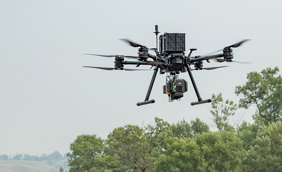
Lighter, more affordable LiDAR systems are now available as drone payloads.
Photo courtesy NDDOT
A hurdle state agencies must contend with is federal regulations. Procedures for state agencies must be created in alignment with FAA regulations, which have evolved as UAS use has become more common. “Right now, there is not enough documentation nationwide to formulate manuals of practice,” Quiroga says. “The DOTs are just beginning to explore the use of these devices.”
The Texas Dept. of Transportation (TxDOT) has not yet deployed UAS-mounted LiDAR, but the agency is looking at the future possibility of using drone-based systems to meet its needs.
The first step will require creating guidelines for the use of various technologies on UAS, and formulating its requirements to meet regulatory compliance, according to an RFP from TxDOT. The agency is currently seeking a research team to evaluate technology and establish guidelines for quality assurance and control when using LiDAR and photogrammetry, as well as identifying projects where these technologies may be suitable.
Looking for quick answers on construction and engineering topics?
Try Ask ENR, our new smart AI search tool.
Ask ENR →


