First Street Foundation Model Expands Flood Risk Parameters
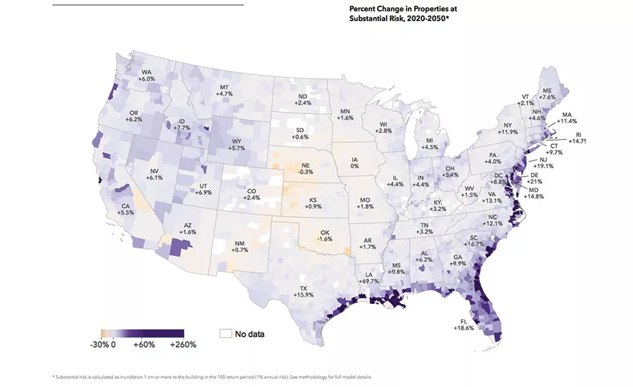
Percent Change In Properties At Substantial Risk, 2020-2050
The model analyzes current and projected flooding scenarios through 2050. This map highlights change over time for a 1-in-100-year event.
IMAGE COURTESY FIRST STREET FOUNDATION
A new flood model from the nonprofit First Street Foundation nearly doubles the number of properties the Federal Emergency Management Agency’s Special Flood Hazard Area had identified as at risk in a 1-in-100-year flood event.
In addition to looking at the potential for riverine and coastal flooding, as FEMA does, the First Street model, using recurrence intervals ranging from 1-in-2-year events to 1-in-500-year events, analyzes the effects of rainfall, sea-level rise and ungauged streams while incorporating climate change projections. Of those, “the biggest impact really is the sea-level rise because it’s pushing flood waters in the coastal areas into locations that previously did not flood,” says Mike Amodeo, director of data science at First Street Foundation.
“There’s nothing like this that I’ve seen,” says Robert Traver, professor of civil and environmental engineering and director of the Villanova Center for Resilient Water Systems at Villanova University. “There’s a lot of different combinations of storm events, they all have their different models, and this kind of put them together.”
The model also takes into account flood control measures that have been put into place in states like Arizona, New Jersey and Louisiana. First Street’s model shows those states with fewer properties currently facing flooding risks compared with FEMA.
“FEMA maps are created for a different purpose than what we’re doing, and we’re hoping, and I think FEMA sees as well, that this data is really complementary,” says Amodeo.
The information is available as a public-facing tool, called Flood Factor, that allows individuals to look up the likelihood and scale of flooding, current and future, for a particular address. The data set resulting from the model is also being used by partner institutions, currently 20 university groups, for research on issues that include flood risk mitigation and adaptation, equity in resilience efforts and influences on federal risk reduction projects.
For Gerald Galloway, flood expert and professor at the University of Maryland’s Dept. of Civil and Environmental Engineering, the model’s advantages include its ease of use and more widespread coverage than FEMA’s models.
Looking for quick answers on construction and engineering topics?
Try Ask ENR, our new smart AI search tool.
Ask ENR →
The utility of any model, Galloway says, “depends on what you’re trying to do. I am personally trying to get Congress and the states to recognize … they are not taking care of the areas where the poor and people of color live, and we’re not solving [their continuing flood problem].”
The model will be updated regularly.
Tentative plans involve quarterly updates and comprehensive annual updates. Future versions will seek to add more precise data on dams, urban areas and stormwater systems and will include flood risk information for Alaska, Hawaii and Puerto Rico.


