Thermal Imaging Feature Streams on the Fly
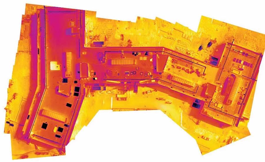
New Thermal Live Map tool gives drone operators a real-time view of thermal data.
IMAGE COURTESY OF DRONEDEPLOY
A software and drone-data platform developer has released what it claims is the first mobile mapping feature to deliver thermal maps of target areas as the data is being collected, for real-time evaluation in the field.
DroneDeploy announced the availability of the Thermal Live Map on June 12. The feature joins a similar, visible-spectrum live-viewing capability released in February.
The live-map tools let operators view the data on the drone controller screen as it is collected and while it is stitched into a view of the entire site being photographed. In the case of the thermal view, the display is color-coded to reveal temperature variations. The information can be used to support quick decisions on site while flight operations are underway. The data also can be uploaded to the DroneDeploy platform for later sharing and viewing.
Ryan Moret, the southern regional field solutions manager for McCarthy Building Cos., says he had been asking the vendor for such a tool for almost a year, and started field testing and helping to tune it up for a product release this spring. “We’re excited about what it can do for us,” he says. “This could be so much easier. It definitely will speed getting from a photo to something that is meaningful and putting it into the team’s hand.”
Moret explained that seeing anomalies immediately in the context of their surroundings adds a lot of value. “We use thermography pretty widely now. We do it for building enclosures and search for leaks, water damage and things of that nature on existing buildings.” He says seeing an image of the full site as it is collected, rather than just ending up with a photo of the anomaly, will make the data more meaningful and improve the way insights are communicated. Moret adds, though, that he thinks the real-time view will be especially useful for inspecting solar farm panel arrays.
Moret says current practice is to fly low and slow with a thermal camera taking high-resolution still images for postprocessing and match-up to the map of the facility. Problem panels are hotter than ones performing properly. “You have countless solar panels. You fly the thermal camera over and maybe you break it down into a grid. Every time you find an abnormality you mark it on a plan to give context of where the photo was taken, and do it all day long sitting in the desert working on snapshots, using whatever mark-up tool we have.”
“With the live app that DroneDeploy has put out, we can fly faster because we are not stopping to take photos, and we can give that to the foreman or superintendent sitting right there to address live.”
Looking for quick answers on construction and engineering topics?
Try Ask ENR, our new smart AI search tool.
Ask ENR →