| + click to enlarge |
|
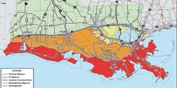
The entire coast of Louisiana, and parts of Texas and Alabama are under voluntary or mandatory evacuation orders. (Map courtesy of Louisiana Office of Homeland Security and Emergency Preparedness)
|
“We are in the midst of evacuation,” said Maj. Tim Kurgan, spokesman for the U.S. Army Corps of Engineers’ New Orleans District when reached on his blackberry in New Orleans on Sunday afternoon, Aug. 31.
The National Weather Service’s hurricane center has posted a hurricane warning for Hurricane Gustav, approaching New Orleans from the south, from Cameron, La., to High Island, Texas. The warning means hurricane conditions are expected within 36 hours.
As of 1 p.m. CDT, reconnaissance aircraft reported Gustav centered about 270 miles southeast of the mouth of the Mississippi, moving northwest at about 17 mph with sustained winds of 115 mph and higher gusts. Some intensification was forecast for the next 12 to 24 hours. Hurricane force winds extended 50 miles from the center, with tropical storm force winds extending outward 200 miles.
Louisiana state police estimated that roughly 95 percent of 1.2 million residents of coastal parishes under mandatory or voluntary evacuation orders have left. He said about 200,000 people have left New Orleans.
|
In eastern Texas, where Hurricane Rita’s surge overran low-lying areas in 2005, a mandatory evacuation began at 6 a.m. Sunday. Authorities evacuated about 6,000 people from a three-county area surrounding Beaumont and extending to the Louisiana-Texas border. In Mississippi, coastal Hancock, Harrison and Jackson counties are under mandatory evacuation orders. More than 7,000 families still live in temporary state and federal disaster housing there, according to the Mississippi Emergency Management Agency. In Alabama, Gov. Bob Riley issued a mandatory evacuation order for some coastal areas of Mobile and Baldwin counties.
In New Orleans, Kurgan says the Corps is preparing to hunker down with a skeleton staff in a bunker at its headquarters in New Orleans, a quick response team at Port Allen, on the Mississippi River near Baton Rouge and a temporary headquarters at the Mississippi River Division headquarters in Vicksburg, Miss. Kurgan says the disposition of the command posts is like that used during Hurricane Katrina, three years ago, but “the difference is we have enhanced communications with multiple layers of redundancy.”
The Corps also has stationed liaisons in 13 coastal Louisiana parishes
“We will move to the bunker when weather conditions dictate,” says Kurgan. By 6 p.m. Sunday night he says operators are also to be in place in hardened facilities at all of the city’s canals that have been fitted with storm-surge gates since Hurricane Katrina. They are to stay at the 17th Street, London and Orleans outfall canals on the East Bank and at the Harvey Canal Sector Gate on the West Bank, for the duration. They are to work the gates and bypass pumps as situations dictate. ![]()
The The three East Baqnk outfall pump stations are capable of moving 16,000 cu ft per second of stormwater out of the city. The pumps at the Harvey Canal Sector Gates can pass 3,200 cu ft second of stormwater around those gates if they must be closed during a storm. A computerized system monitors the water level in each canal remotely. Rainfall is expected to range from 6 to 12 inches over portions of the region, with isolated maximum amounts of up to 20 inches possible.
The storm has been difficult to model, with significant disagreement in track and intensity predictions with each pass of the data through the various weather modeling software products employed, but as of Sunday afternoon the consensus prediction was for 12-16 ft storm surge coming at the levees near and to the east of the point where the center of the storm makes landfall.
“The predicted track is west of where Katrina went, which would push surge on the West Bank,” Kurgan said. The perimeter levee protecting the West Bank side of the Greater New Orleans metropolitan area is “right around 10 feet,” he added.
The West Bank defenses are part of the hurricane protection system authorized by Congress decades ago, but only funded, until Hurricane Katrina, in dribs and drabs. Portions of the West Bank actually have no defenses tied into the larger system at all.
Even so, if the existing levees are overtopped Kurgan says unwatering the area will pose challenges. If the storm moves as predicted, Kurgan says, damage assessment teams from the Corps may be able to start moving back into the area by Wednesday morning.


Post a comment to this article
Report Abusive Comment