California Canal Foes Resist Alignment Assessment Teams
A California county judge on May 6 ruled that two landowners cannot block access to their property to prevent engineers from studying possible routes for a 600-ft-wide and possibly 50-mile-long canal to help move water from northern sources to Southern California users. About half the owners of 125 parcels have denied access. The ruling in Contra Costa County that said two of them cannot stop the state from collecting biological and geological data on their farms—a ruling sought by state Attorney General Jerry Brown—is the first in the matter. Access requests for another 388 parcels are planned.
“We are pursuing the essential parcels in court,” says Richard Sanchez, the Dept. of Water Resources division engineering chief managing the Delta Habitat Conservation and Conveyance Program.
The Washington Division of San Francisco-based URS Corp. has a seven-year, $60-million program-management contract for the study. Omaha-based HDR Inc. also has a $25-million contract for route studies.
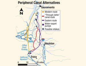
Ensuring water supplies for 25 million people and 2 million acres of farmland by conveying it by a “peripheral canal” rather than by natural flow across the environmentally sensitive and seismically vulnerable Sacramento-San Joaquin Delta is a controversial idea. State voters decisively rejected a similar plan in 1982. But recent fish population declines and a three-year drought have revived it. Proponents say a canal would more reliably deliver water from the Sacramento River to pump stations in Tracy, yet leave enough flow to sustain fish and keep San Francisco Bay’s saltwater from backing into the delta.
A variety of routes are being considered that could be paired with an improved “through-delta” channel to maintain South Mokelumne River flow. Consultants may use auger drills, cone-penetration tests and trenching to gather geotechnical information, according to the Bay Delta Conservation Plan.


