After Sandy, FEMA Flood Maps Are a Moving Target
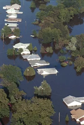
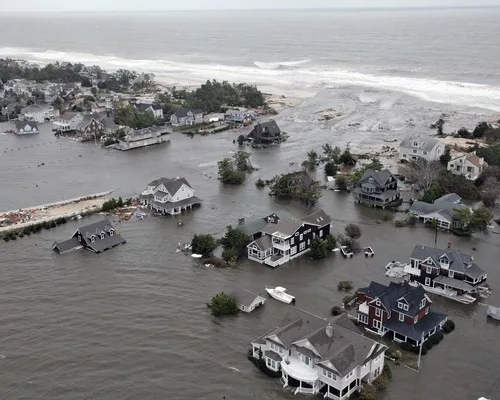
Over recent months, a new storm has roiled the storm-battered communities of New York and New Jersey.
The Federal Emergency Management Agency's "advisory base flood elevation" (ABFE) maps—delivered to guide the start of the post-Sandy rebuilding of homes, businesses and public facilities until more comprehensive "flood insurance rate maps" (FIRMs) can be completed—have been assailed by local residents and leaders. Many complain the ABFEs overstate the vulnerability of areas to flooding and thereby drive up insurance costs, while numerous scientists, on the other hand, complain the maps underestimate the potential effects of climate change. (For more information on the maps, see FEMA's Web page.)
The agency's response—that some map elevations likely will change as studies are finished and new FIRMs are rolled out this summer—has failed to quell the storm.
Even in accepting the advisory maps, New Jersey Gov. Chris Christie (R) vowed they would be revised and reissued, "and then they're going to be revised again after that."
While that sounds like political defiance, it is, by regulation, the way the revision process works. In this case, the process coincides with the conclusion of a long-running project to update flood-hazard data, which is a decades-long evolution of FEMA's approach to managing the data, and, of course, the trauma of Superstorm Sandy itself.
How It works
The coastal and riverine flood-risk mapping program began as a way to improve floodplain management and reduce federal costs for disaster recovery. To get subsidized insurance, the program requires flood-prone communities to participate in the National Flood Insurance Program (NFIP), established in 1968. According to FEMA, mapping "creates broad-based awareness of the flood hazards" and provides data for floodplain management and rating new construction for flood insurance. Since local flood zones were first delineated, however, long periods have often passed between updates.
"The process was driven by the insurance industry, which just wanted to know where policyholders were," explains Larry Larson, director emeritus and senior policy adviser for the Association of State Floodplain Managers (ASFPM). "As more agencies and commercial interests began using the maps for evacuation planning, community development and other purposes, deficiencies in accuracy and detail became apparent."
A Drive To Update
A five-year, $1-billion effort to update flood maps was completed in 2007. It led to a shift in how FEMA interacts with map users. Although local stakeholders always had a role in setting the parameters for the one- to three-year-long studies to develop engineering data for the maps, the process—called "risk mapping"—is now more collaborative and high tech. Modern technologies are routinely used both for data collection and to help agencies see how the data can aid emergency and land-use planning, risk mitigation and resource management.
Also, analysis technology has made it possible to consider predictions of future conditions, rather than relying only on benchmarks of historic events, although it took last year's passage of the Biggert-Waters Flood Insurance Reform Act to mandate that such projections be weighed.
However, that act's mandate to consider predictive analysis was passed too recently to influence calculations behind the revised FIRMs that are about to come out for New York and New Jersey. They face a 90-day appeal-and-review period before final adoption. But even a finalized FIRM isn't forever, notes Sally McConkey, ASFPM chairwoman and University of Illinois engineer. She says it may be years before the effects of climate change on flood risk are well understood; however, if climate-driven revisions are needed, the maps are open to modification from the moment they're issued, she notes. "It might be 20 years or more before a community is remapped, but there are procedures in place to initiate revisions right away," she says.
"The ideal approach would be to continually refresh and update the maps," McConkey adds, but doing so would be costly. An ASFPM study put the price of updating the nation's flood-map inventory at $4.5 billion to $7.5 billion, with annual maintenance costs of up to $275 million.
Instead, Briggert-Waters authorizes $400 million for mapping updates; of that total, only a fraction is expected to be budgeted.
Briggert-Waters also eliminates a grandfather clause that let NFIP-subsidized policyholders pay the rate from original floodplain maps for their properties, regardless of changes that occurred—a provision that contributed to NFIP funding shortfalls. As a result, some owners now face not only higher insurance costs due to increased flood risk but also insurance premium increases of up to 25%—unless they make modifications, such as elevating structures.
Despite the complaints about the potential inaccuracies of the ABFE maps, the alternative was to begin rebuilding with outdated information, says Jerry Sparks, vice president with longtime FEMA technical services contractor Dewberry, Fairfax, Va., which was completing FIRM updates for parts of New York and New Jersey when Sandy hit. "That might have put property owners at greater risk as the hazard in many areas had clearly changed," Sparks says.
Because much of the data for the new FIRMs was in hand when Sandy came ashore, FEMA authorized Dewberry and its partner firms, URS and ESP Associates, to speed completion of coastal and overland storm-surge data to expedite release of the advisory elevations.
ENR's full report on how Sandy-struck regions are coming back is here.

