
Though the tone is unusually civil, critics are sharpening their knives in Louisiana as recovery starts in flooded areas outside the circle of defenses that protected New Orleans from Hurricane Isaac's storm surge on Aug. 26-29.
Storm surge reached 14 feet on the flood defense system's new 26-ft-tall barrier at the western end of Lake Borgne, which blocks one of two principal access points to waterways connecting Lake Pontchartrain, above New Orleans, to the Gulf of Mexico. The barrier took the full onslaught of Isaac's storm surge. Without the barrier, water would have reached much less capable defenses at the edges of the city and almost certainly would have flooded the interior.
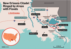
But unusual flooding occurred anyway in a number of areas outside the $14.6- billion Hurricane Storm Damage Risk Reduction System (HSDRRS), which was put in place by the U.S. Army Corps of Engineers during the recovery from Hurricane Katrina in 2005.
Areas flooded by Isaac include large parts of the parishes of Plaquemines, lower Jefferson, St. John the Baptist, and some parts of St. Tammany and Tangipahoa, including the town of LaPlace, at the far western end of Lake Pontchartrain.
Many shocked residents of those flooded areas and some of their elected officials are calling for investigations to see if the new defenses made those areas more vulnerable to flooding.
In an Aug. 31 letter to Jo-Ellen Darcy, Army assistant secretary for civil works, U.S. Sen. David Vitter (R-La.) said "the good news" is that the hurricane protection system in metropolitan New Orleans performed well. "The bad news is that there was significant flooding in several areas outside the system, in many cases at unprecedented levels," he added.
"The people in those areas deserve a careful, scientific and expedited review of this issue by outside, independent experts," Vitter wrote. An "obvious and legitimate" question, he noted, is whether and to what extent the post-Katrina system "made flooding worse in those other areas outside the system because of a funneling effect or similar impact."
In closing, however, Vitter added a note of thanks to the Corps for the work of its personnel during the storm, saying, "I was embedded with many of them at the Corps' New Orleans headquarters and saw much of that important work firsthand."
While not calling for an inquest, U.S. Sen. Mary Landrieu (D-La.) said the storm damage "has reinforced for us, once again, just how vulnerable these critical areas are. We must re-engage the Corps of Engineers on this. There are still too many areas without protection, and we have a lot of work left to do."
In a tweet while inspecting damage, Landrieu said Isaac underscores the inadequacy of the $2-billion federal budget for levee construction and upkeep. Louisiana alone could use $1 billion annually, she said.
In response, the Corps said in a statement that it will perform additional modeling and post-storm evaluations "to help better understand changes in surge behavior resulting from systematic changes." A time line for the complex runs of computer modeling is under development.
"We expect the results to indicate that changes in surge elevation are minimal but will defer further comment until the science and engineering work is completed," the statement added.
Modeling and Analysis
The Corps performed extensive preconstruction storm-surge modeling and analysis in developing the system, which consists of 133 miles of levees, floodwalls, gated structures and pump houses. The design-vetting process used the "best available science and engineering" and independent external peer review, the Corps said in its statement.
"With the exception of the Inner Harbor Navigation Canal (IHNC) Surge Barrier, Seabrook Floodgate Complex, and the Permanent Canal Closures and Pumps on the south shore of Lake Pontchartrain, the footprint of the new HSDRRS system is essentially the same as what was in place prior to Hurricane Katrina," it added. IHNC Surge Barrier modeling prior to construction indicated the structure could cause insignificant, unintended consequences, the Corps says.
Other Voices
Independent experts agree it is unlikely the HSDRRS worsened flooding for areas outside the perimeter.
"The system has absolutely nothing to do with flooding in LaPlace and Braithewait," says civil-engineering professor and computational hydraulics expert Joannes J. Westerink, Notre Dame University. "If you think about it, the system was put on the same footprint of what was there before." That means the new defenses did not increase the area protected by the old system—when the old system held up to storms.
The few new features, given their locations, would have had a negligible effect on the way the storm surge flooded other locations, Westerink says. The characteristics of this particular storm itself were to blame, he adds.
Westerink is one of the co-developers of the widely used ADCIRC finite-element-based shallow-water equation model whose high-resolution analysis was extensively used in the post-Katrina forensic investigation of the disaster and in planning and designing the new defense system.
Westerink noted that Isaac was a very slow-moving storm and, therefore, poured large amounts of surge and rainfall onto the region. The storm camped near the mouth of the Mississippi River for more than a day, with counterclockwise winds pumping water over an extended period of time into vulnerable areas, such as Plaquemines Parish and The Rigolets, an unprotected waterway leading into Lake Pontchartrain from the east. The strong and continuous wind drove water toward the north shore of Lake Pontchartrain and toward its western end, where extensive flooding occurred. By contrast, Katrina and other recent storms moved through the area much more quickly.
"It was just a very slow storm with long exposure and a lot of time to fill up Pont-chartrain. That's why you had these problems," Westerink said.
Another expert on the subject, Lewis "Ed" Link, a University of Maryland civil engineering professor who chaired the independent multidisciplinary task force that examined the performance of New Orleans' old flood protections and who has advised extensively on their replacement, holds the same view. Isaac's track also coincided with the worst possible path a hurricane could take for inflicting storm surge, based on the 152 hurricanes modeled for those analyses, he adds.
Those supercomputer-generated models form a suite of storms that span the gamut of possibilities in terms of intensity, course and speed. The models and the extrapolations made from them form a storm-risk baseline for the Louisiana Gulf Coast area. He says they were run with and without the new storm defense system during design development; they showed "absolutely no difference" in area effects.


