Technology
Quantum Gravity Sensor Tests Point to Better Subsurface Mapping
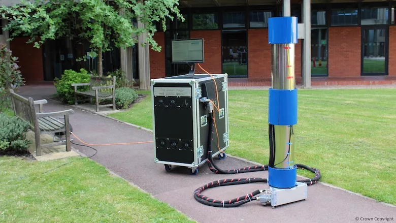
Photo Courtesy University of Birmingham
U.K.-based researchers have, for the first time, field tested a quantum gravity surveying instrument that could potentially produce Google-type maps of the subsurface. By eliminating the "noise" of unwanted readings, the new sensor device developed at the University of Birmingham is claimed to be more accurate and up to 10 times faster than current instruments.
The team built its quantum gravity gradiometer into a mobile instrument and surveyed an underground concrete utility tunnel on its campus. Their results of their study were published in the scientific journal Nature last month. The team led the government-funded program as part of the National Quantum Technology Hub in Sensors and Timing, whose members include major U.K. universities and government labs.
"What's really important is that we've demonstrated what detectability and therefore sensitivity we have, and we've used this tunnel as a proxy," says Nicole Metje, professor of infrastructure monitoring in the university's civil engineering department.
"Only a quantum sensor...will ever have the ability to be a mobile instrument," says Metje. "The classical mass on a spring [device] will never be able to do that because it will never be able to [take average readings] over a short period of time."
To identify underground objects and features, site investigators have used gravity instruments essentially based on movements of a mass on spring. The spring extends to varying degrees depending on the gravity pull of a buried object, which relates to its density.
But "it's impossible to differentiate between gravity and acceleration [caused by] any vibrational 'noise,'" says Metje. Construction traffic, wind or even distant tidal movements can cause such noise, which is difficult to strip out from survey readings. And long measurement times are needed to remove the effects of vibrational noise, making surveys slow, she adds.
Developed by Michael Holynski, the university’s head of atom interferometry, the new instrument negates the effects of vibrations and other disturbances. Basically, the instrument fires laser pulses into clouds of atoms sending them on two different paths. Using interferometry to compare the paths reveals local differences in gravitational fields.
Looking for quick answers on construction and engineering topics?
Try Ask ENR, our new smart AI search tool.
Ask ENR →
To remove noise, the Birmingham device observes two sets of atom clouds at different distances from the feature being explored. While the resulting gravity readings will be different, the noise levels will be identical. Subtracting the two sets of results eliminates the noise without delay.
"Existing technology is as good as it's going to get," says George Tuckwell, director of geoscience and engineering at the environmental consultant RSK Group Ltd. Tuckwell led an earlier project linked to the gravimeter's development. But he's also a practitioner, paid to "make detailed measurements of gravity."
Though effective, the Birmingham instrument incorporates excessive redundancies that need removing before being put on the market, says Tuckwell. The main sensor is around 6.2 ft tall with a roughly 4.3 sq ft footprint. It is connected to a laser and control system trolley, raising the total weight to about 550 lb.
Since "in any construction, the biggest risk at the outset is unforeseen ground conditions," the instrument will be a valuable tool when it reaches the market, possibly in two years, believes Tuckwell. "There is so much potential for it that whoever gets there first is going to have a lot of takers."


