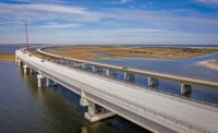
For nearly 60 years, the humped profile of the Herbert C. Bonner Bridge at Oregon Inlet has been a familiar landmark on the scenic stretches of North Carolina’s Outer Banks. Now, joined by the taller, more streamlined contour of an adjacent $246-million replacement structure, the ocean and barrier island ecology compete for attention with new columns and spans rising above the junction of the Atlantic Ocean and Pamlico Sound.
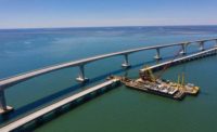
The new center of attention is a 2.8-mile-long, 42-ft-wide hybrid structure, crafted by the design-build team of PCL Civil Constructors and HDR Engineering. The 71 approach and transition spans, totaling 2.1 miles, consist of Florida I-beam girders rising 70 ft to connect with an 11-span, 3,550-ft-long continuous segmental box girder unit across the inlet’s center.
This eye-catching construction effort overshadows the complicated technical and logistical issues that required resolution as well as the protracted legal battle that sidelined construction for nearly four years after the project was awarded in 2011.
In a perfect world, the North Carolina Dept. of Transportation (NCDOT) would have replaced the Bonner Bridge in the early 1990s, about the time the 2.3-mile-long, 260-span concrete segment crossing reached the end of its 30-year design life. A 1990 collision by a runaway dredge dislodged a 250-ft section near the bridge’s north end, isolating Hatteras Island’s tourism-based communities for nearly two months and raising new worries about the vulnerability of the remote island’s lone highway to the mainland.
NCDOT’s replacement plans were repeatedly stymied, however, by a series of lawsuits claiming that state and federal regulators had not fully assessed a new structure’s effect on an environmentally sensitive corridor that includes a federally protected wildlife refuge. It was only after NCDOT agreed to address overwash-prone areas on Hatteras Island that the lawsuits were settled and work on the Bonner Bridge’s replacement could finally begin in August 2015.
Article Index:
Location, location
PCL/HDR was hardly idle during the many months of litigation, collaborating on a design capable of withstanding the Outer Banks’ harsh marine environment for at least a century while also accommodating ocean and soundside currents that continually alter the inlet’s shape. And though the area attracts millions of visitors each year, Oregon Inlet is, from a construction standpoint, relatively remote. That made access, labor and logistics as critically important as the constructibility of the design.
HDR design manager Domenic Coletti explains that the hybrid structure allows for 350-ft-wide middle spans, well above NCDOT’s minimum requirement of 200 ft, with a 2,400-ft-wide navigation zone that better accommodates natural migration of the underlying sands. The original bridge’s sole 130-ft-wide navigation channel required near-continuous dredging funded by the Corps of Engineers to preserve 30 ft of depth for pleasure boats, fishing charters and small barges. Elsewhere, Oregon Inlet shallows to as little as 5 ft.
“With these scour depths, piles must be installed to a much higher resistance load.”
– Domenic Coletti, Design Manager, HDR
Should the channel migrate from one span to the next, “the Corps can simply relocate the navigation lighting from one pier to the next,” Coletti says.
The design also maximizes the use of precast concrete, a feature that PCL construction manager Sean Bush says ensures both quality and durability while also helping reduce overall costs.
And “maximize” may be an understatement. When complete, the new Bonner Bridge will boast more than 17 miles of 36-in. square piles and 54-in.-dia cylinder piles, 8.75 miles of prestressed I-beam girders, 0.3 mile of post-tensioned columns and 0.67 mile of post-tensioned box girders.
“Precast allows us to fabricate the components in a controlled environment and economize by using black steel for reinforcement,” explains Bush, adding that some cost escalation occurred during the four-year delay. “Our contract included a provision to modify the bid, and we used ENR cost indices to calculate the difference.”
Pablo Hernandez, NCDOT district engineer, adds that the project team has worked with supplier Coastal Precast of Chesapeake, Va., to fine-tune aspects of the fabrication process to incorporate other safeguards against the harsh environment.
For the voided precast concrete caps on the approaches, the project team developed measures to control cracking in the cap shell, using stainless steel at the precast yard for the areas of the shell that will be filled with concrete on site, for roughened surfaces on precast portions that are filled with concrete on site and for sealing pour joints with epoxy.
NCDOT also worked with PCL to change sole plates in the bearing assemblies from galvanized plates to stainless steel. As a result, “Coastal Precast had to cast a stainless steel embed plate in the bottom of the precast concrete girders such that the girder could be welded to the stainless sole plate at the bearings,” Hernandez explains.
As these and other measures make for a demanding fabrication process, Hernandez adds, “the concrete producer has to be on board with it.”
Underwater, the new bridge’s foundation is designed to safeguard the structure from scour, a problem that had become increasingly problematic for the original Bonner Bridge. In November 2013, for example, excess erosion around a bent near the bridge’s southern end forced a two-week closure while an emergency dredging operation stabilized the area.
To minimize the potential of such sudden disruptions, HDR specified pile depths of 120-140 ft to reach hard sand in each of the inlet’s five scour zones and to ensure a minimum mid-channel scour depth of 84 ft. The middle spans use clusters of 36-in. square battered prestressed piles combined with a cast-in-place footing.
“With these scour depths, the piles must be installed to a much higher resistance load,” explains Coletti, adding that the less vulnerable approach spans are founded on bents composed of three to four 54-in.-dia cylindrical piles to a cast-in-place pile cap.
Into the sand
Foundation work began amid the choppy waters in the middle of Oregon Inlet, with jetting used to help navigate each pile through dense sands. “We jet through this sand layer to within 10 to 20 feet of the final tip elevation, then drive to final elevation,” Bush says.
To ensure that the installation process didn’t reduce each pile’s required scour resistance, HDR’s geotechnical engineers developed an innovative method for calculating installation-related scour loss.
“The method is based on the actual measured resistance of the pile, rather than a conservative calculated value,” Coletti explains. “This helps avoid the risk of being over-conservative and driving the pile to a much higher load, which would take more time and more pile length and cost more money.”
With the piles in place, PCL used barge-mounted cranes to construct cast-in-place waterline footings, precast footings, segmental hollow-box columns with 1.5-ft-thick walls and pier caps. A “pier table,” made up of two pier segments, is constructed above the pier cap, then raised as column segments are installed in pairs to keep the cantilever in balance. Once the pier table is aligned and bearings grouted, PCL installs lifters to erect the 14-ft-long, 42.5-ft-wide superstructure segments, which range from 9 to 19 ft deep.
Land-based construction proved more feasible for the new bridge’s girder-based approach sections, though sensitivity to environmental conditions influenced the project team’s approach.
To get the nearly 5,800-ft-long north approach span underway amid grassy marshes, for example, PCL erected a 1,600-ft-long temporary timber access trestle and created a “train” process to support the driving of the 54-in.-dia cylinder piles, pier construction and cranes needed for lifting the 140- to 160-ft girders into place. A movable “finger pier” enables the crane to reach the furthest girder placement from the trestle, then pulls back for the remaining units. A smaller trestle at the far end of the north approach allowed girder span construction to work backward.
Eyes on the skies
Understandably for an area known as the Graveyard of the Atlantic, PCL and NCDOT have closely monitored weather around Oregon Inlet, especially when the approach of major storms poses potential issues with high winds and seas.
Demobilization takes about two days, Bush says, including securing equipment and barges. Despite the precautions, one equipment barge managed to escape its moorings during Hurricane Matthew in October 2016 and was recovered in shoals several miles away.
August and September 2017 were a particularly hectic period for weather-related interruptions, with four storms passing close enough for work to be shut down.
What proved to be the most highly publicized incident during bridge construction occurred in the early morning hours of July 27, 2017, when crews inadvertently drove a steel casing into a buried, three-cable 115-kV power transmission line at the south end of the new bridge. The incident, which occurred during a clean-up operation as workers were relocating the casing for storage, caused a week-long power outage on Hatteras and Ocracoke islands during peak tourist season and forced the evacuation of 60,000 visitors.
PCL took responsibility for the disruption, which didn’t affect bridge construction. The incident did spark numerous lawsuits from Outer Banks residents, businesses and tourists that have since been consolidated into a single action, currently pending in federal district court. PCL also invited those affected to file claims with the company and avoid litigation. PCL declined to release both the number of claimants and the amount of money paid out to date.
Local officials have estimated total losses from the incident to be as much as $16 million. Still, Bush says, “it was good to see the community come together and tackle what was a difficult situation for everyone.”
Bush is hopeful the project’s remaining months will be far less eventful, though he remains mindful that winter storms can have as great an impact on construction as summertime hurricanes. Pile-driving is scheduled to finish up in the spring, followed by completion of the segmented sections and the bridge deck pouring.
“We’re looking to open the bridge to traffic in late fall,” he says, after which most of the old Bonner Bridge will be demolished. Except for a 1,000-ft section at the south end that will be repurposed into a fishing pier, the old bridge’s material will be deposited at several offshore reef sites.
By the end of 2019, the cranes and barges will be gone, and the new Bonner Bridge will have been fully integrated as a landmark for motorists making their way to the Hatteras Island beaches. While the legal strife that complicated its creation may fade from memory, Coletti says the real-time collaboration across the project team that made the new structure possible will be a lasting lesson for comparable projects.
“Whatever one discipline did affected all others,” he says of the project’s teamwork. “We couldn’t have been successful without it.”


Post a comment to this article
Report Abusive Comment