Map-Based Tool Offers Easy Access to Project Data
Clicking on a map, a user can drill down to take a virtual tour of a stretch of track, with the ability to stop and look for specific data about a physical asset.
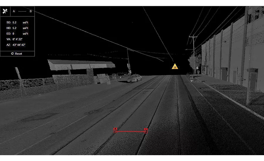
PHOTO COURTESY OF PAUL DIGIACOBBE/MASER CONSULTING
A geo-referential portal that allows project team members at all levels to easily access “heavy” infrastructure data is gaining traction in the transportation industry. The project data-sharing solution, called uGRIDD, has been adopted by a dozen agencies in the five years since its development, with more coming on line.
Paul DiGiacobbe, director of geospatial services for Maser Consulting, Red Bank, N.J., says an increasing number of clients are expressing interest, including Kiewit Construction and rail and transit agencies in New York and Pennsylvania.
“We work with heavy data, like mobile LIDAR data. To be able to look at the data, measure and absorb it and be a consumer without having a CAD platform is a pretty big deal,” DiGiacobbe says. “You don’t need special software or a high-powered computer.”
An acronym that stands for “Your Geo-Referenced Infrastructure Data Depository,” uGRIDD offers a web portal that lets clients locate specific infrastructure data by clicking on a map. “One thing all data has in common is location,” says Zhong Chen, founder of Dynasty Group Inc., an engineering and land-surveying firm. “We use that as the primary index—everywhere is somewhere.”
Chen developed uGRIDD five years ago in response to the difficulty users had when wading through oceans of Big Data. “At the project level, especially the capital-improvement level, we collect so many kinds of data. Once the project is done, the data is stored somewhere, and unless something serious happens, no one looks at it again,” he says. “You end up with file cabinets of data information that are a dead weight to the agency. If we can better index the information so we can reuse it, it will bring efficiency.”
Non-specialized users can avoid traditional GIS approaches to publishing and finding infrastructure data, says Steve Schlickman, a uGRIDD spokesman. “The GIS process requires highly trained professionals and is both time- and labor-consuming. Only a limited amount of data can be processed and shared on the GIS platform. With uGRIDD, very little training allows anyone to show, share and host the data. And with just basic browser skills, anyone can easily find the data.”
uGRIDD’s suite of products includes uSHOW, which creates individual web pages for project data that have interactive maps; uKAN, which offers advanced features such as map navigation bars and location synchronization; uFIND, which includes location-based searches for project data; uSHARE, which provides repeatable searches as a project’s data sets evolve; and uPANO, which provides a panoramic viewing interface for LiDAR data, photos and 3D models.
Looking for quick answers on construction and engineering topics?
Try Ask ENR, our new smart AI search tool.
Ask ENR →
When he learned about uGRIDD three years ago, DiGiacobbe says he had concerns about the limits within a 3G network world. But now, with 4G ubiquitous to devices, “it’s amazing how quickly you can break up piles of data into pieces,” he says. “You can zoom in and view a data pile, and what you’re looking for pops up in seconds.”
Users log into the portal, zoom in on the map where the infrastructure system is located and can click on any location along the system—for example, a highway or a track alignment. They can take a virtual walk-through along the alignment and stop at any point to gather more information about a specific section or asset. They can download the information for further analysis and updating, as well.
To gather and store the data, uGRIDD charges $100 per map unit a year. “When mobile LIDAR first came out, you needed massive back-office space” to process the data, notes DiGiacobbe. A $1-million job to survey a rail system included about $20,000 for uGRIDD, he says.


