Nearly 50 Years After it First Began, I-69 Is Nearing its Finish Line in Indiana
The new overpass of I-69 in Martinsville, Ind., was built as part of the I-69 Finish Line project, which includes a widening of the former State Road 37.
PHOTO COURTESY OF MILESTONE CONTRACTORS
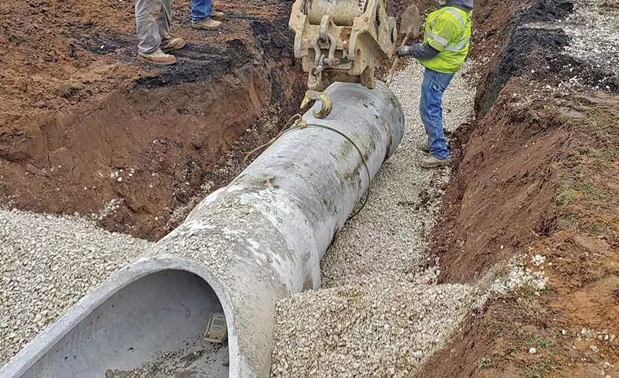
Almost all of the new route required upgraded drainage infrastructure, including new pipes and culverts.
PHOTO COURTESY OF THE INDIANA DEPT. OF TRANSPORTATION

The route includes 39 new bridges and 10 Interstate access points.
PHOTO COURTESY OF THE INDIANA DEPT. OF TRANSPORTATION
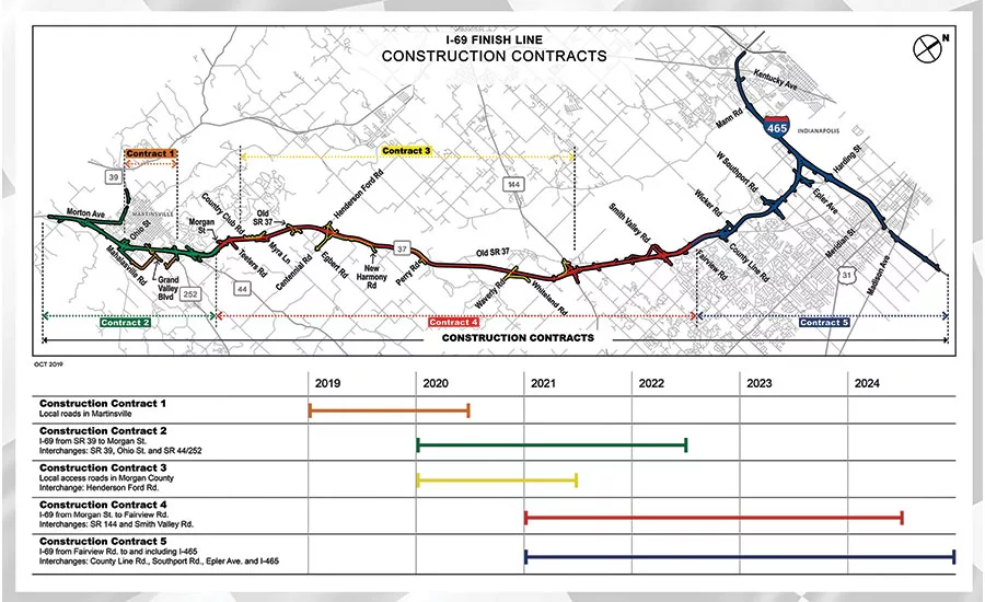
The overall project is broken into five separate contracts and stretches from Evansville, by the Kentucky border, to Indianapolis.
PHOTO COURTESY OF THE INDIANA DEPT. OF TRANSPORTATION
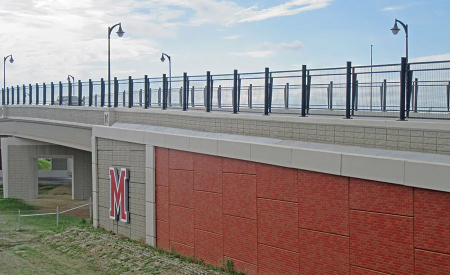
During the design phase, HNTB and INDOT decided to add the logo of Martinsville High School to the bridge.
PHOTO COURTESY OF THE INDIANA DEPT. OF TRANSPORTATION

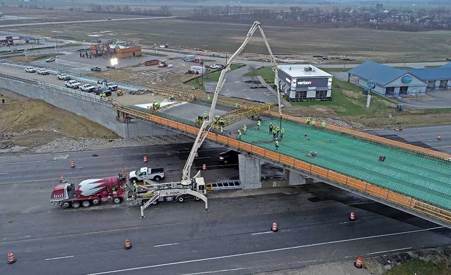
Milestone Contractors placed concrete for the Martinsville Bridge in late 2019.
PHOTO COURTESY OF THE INDIANA DEPT. OF TRANSPORTATION
By 2024, a new interstate will stretch from the Canadian border in Michigan to the Indiana-Kentucky line thanks to a $1.5-billion highway and reshielding project.
Interstate 69 was first pitched in the 1940s as a single, continuous route from the Texas-Mexico line to Canada. While states such as Louisiana and Mississippi still seek federal money before starting their portions of the border-to-border highway, Indiana is closing in on finishing its part of I-69 that started in 1971.
The “finish line” portion being completed in southern Indiana involves 26 miles of new highway construction and 35 miles of reconfigured roads stretching from Martinsville to Indianapolis. It upgrades the existing State Road 37 to interstate standards and eliminates at-grade crossings, adds overpasses and local access road connections and 10 interstate access points throughout the corridor.
The project’s northern I-465 terminus will include adding a travel lane between I-70 near the Indianapolis airport to I-65 on the southeast side of the city. Once completed in 2024, I-465 will be reshielded to I-69 on the southeast and east side of Indianapolis to the existing I-69 terminus on the northeast side of the beltway. To bring SR 37 up to standards, more than 35 lane-miles of new local access roads and 39 new bridges need to be added while existing bridges need to be rehabilitated. By 2024, I-69 will run continuously from Port Sarnia, Mich., to Evansville and the Kentucky state line.
“During the environmental process, when we got into right-of-way acquisitions, we really tried to minimize the impact.”
– Sarah Rubin, Deputy Director of Projects, INDOT
Project challenges included providing access, minimizing real estate acquisition and coordinating utilities while reconfiguring much of the existing route to accommodate the new interstate. When the project is completed, the time it takes to travel from Martinsville to Indianapolis is expected to be reduced by 11 minutes thanks to the elimination of 14 signal lights on the state route. Portions of I-69 north of Indianapolis were the ones built as part of other projects since the 1970s.
“Almost all of it needs new drainage infrastructure,” says Tim Miller, senior project manager for designer HNTB, a consultant to the Indiana Dept. of Transportation. “We have moved high-tension power lines, a gas line going along much of SR 37, and considered endangered species and other natural environmental features along the corridor.”
INDOT acquired more than 700 parcels along the corridor, according to Sarah Rubin, agency project manager for the I-69 corridor. Businesses, homes, farmland and such municipal buildings as a fire station had to be acquired along the corridor. The project team focused on minimizing impacts to the natural environment and then mitigating impacts that were unavoidable. Cultural resource challenges for the project included avoiding impacts to archaeological and historically significant properties and structures.
“During the environmental process, when we got into right-of-way acquisitions, we really tried to minimize the impact,” she says. “We met with business groups to understand how their suppliers are getting to them—if there were certain needs or constraints they had. That was a continuous theme throughout the entire corridor. Understanding the assumptions of how people are using the corridor and what the needs of those businesses or residents would be was important. Access and thoughtful placement of interchanges are topics that kept arising.”
Land had to be conserved for a native endangered bat species. Rubin says that some of the limestone quarries in the area remain active, and the final alignment had to consider some of the dormant ones because they may become active again at a later date.
“It’s kind of a balance of what you pull out of the ground versus what inevitably goes back into the ground, too,” she says.
Divvied Up
The I-69 Finish Line project is separated into five different contracts. Four of the five contracts are being delivered through a design-bid-build approach. However, Rubin said that a design-build-best-value approach is being used on the largest contract because it allows bidders to propose design elements, configurations and safety features that may not have been able to be proposed through less nimble, traditional procurement. All five contracts were accelerated by three years at Gov. Eric Holcomb’s direction in 2018 as part of the Next Level Roads program.
Contracts 1, 2, and 3 are under construction, while Contracts 4 and 5 are anticipated to have notice to proceed by the end of the year. Contract 1 was awarded in December 2018 to Milestone Contractors for utility relocation and a new interchange, new local access roads and the overpass in Martinsville. That project began in early 2019. Martinsville is a town that exists in a low-lying area that resembles a natural bowl in the hills of southern Indiana.
“There were a lot of utilities underground that needed to be moved,” says Ryan Whitaker, project manager at Milestone Contractors. “It was pretty isolated, and there was a pretty big effort to get utility relocation done for it. We had to fight the high water table that’s present down there.”
For the overpass bridge, Milestone had to install mechanically stabilized earth walls and install a 9-ft by 5-ft box culvert that runs underneath existing route 37 for drainage. The contractor also had to keep the groundwater underneath the overpass out of their bridge piers and MSE walls during a particularly rainy spring of 2019.
For the mass-concrete bridge piers, the max temperature could not exceed 150°F, and Milestone had to monitor temperature hourly during its pier placements. Bags of ice were used to cool the concrete at its time of placement from the trucks.
“We were trying to think of what would be an inexpensive yet timeless way to connect the aesthetic parts of the bridge and Martinsville High School.”
– Tim Miller, Vice President and Senior Project Manager, HNTB
The bridge has been well received by residents thanks to decisions enabled by the design-build process to make enhancements that were both inexpensive and could be approved by the community.
“During the design development phase—which Sarah [Rubin] and I worked on—we were trying to think of what would be an efficient yet timeless way to connect the aesthetic parts of the bridge and Martinsville High School, which is one side of the overpass,” Miller says. “They had just rebranded their school, which included a large M on a brick pattern that matched the county courthouse. So as part of a collaborative process with local representatives, we came up with the idea of placing a red M on the bridge. The school had a lot of problems with pedestrians, with students crossing SR 37, trying to get over to this commercial center. The brick theme will be carried elsewhere in the corridor.”
Miller said the bridge was welcomed as a safety enhancement because the school and the nearby Wal-Mart, restaurants and other businesses on the opposite side of the highway now have safe east-west connectivity over the pedestrian part of the bridge. Ornamental lighting keeps the bridge lit at night and fencing on both sides enhances safety.
“The intent, for the whole corridor, is that there will always be east-west connectivity so that people can get to and from the schools and the businesses and their jobs,” Miller says. “We are transitioning from a facility that had 92 access points, consisting from private and commercial drives to state and county roads, to just 10 interchange access points.”

.webp?height=200&t=1661545870&width=200 "RESIZED2100-N-Southport_Rendering_HiRes_Credit-Sterling-Bay-and-HPA-(002).jpg")

