Take Me to the River

The Fort Worth area has grown a lot since the historic 1949 Trinity River flood, which prompted creation of the U.S. Army Corps of Engineers’ Fort Worth District and construction of the existing levee system.
Urbanization has resulted in the addition of parking lots, airports and many hard surfaces that prevent absorption of water into ground soil and rivers, creating the opportunity for higher Trinity River levels and increased risk of flooding. “We have outgrown our existing levee system, and we needed a plan that will take us into the next 50 to 100 years,” says Woody Frossard, project manager for that plan.
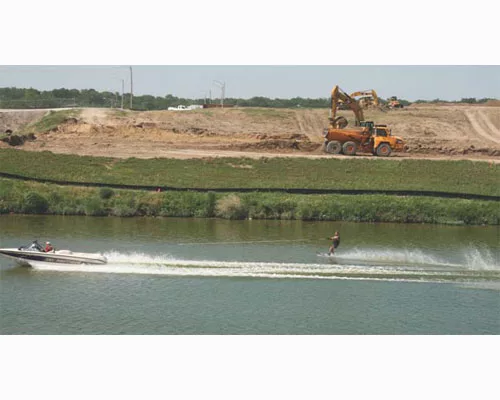
The Trinity River Vision is a master plan that was developed by volunteers and community leaders and adopted by the city, county and state officials for 88 mi of the Trinity River and its major tributaries in Fort Worth. The plan is designed to provide increased flood protection that will allow economic development, while preserving the river corridor for environmental, wildlife and recreational benefits.
The overall project will cost an estimated $909 million and create more than 16,000 construction jobs, says Frossard, citing figures from a University of North Texas economic study. “So far the Tarrant Regional Water District (TRWD), the corps, the city and the Trinity River Vision Authority (TRVA) have hired 110 different firms, with minority-based firms representing 47% of all contracts let,” says Frossard, who is also environmental director of the TRWD, which owns and operates the floodway system.
The new flood controls will be built for an 800-year flood event, says Frossard, meaning a flood that has one eighth of 1% chance of being equaled or exceeded in any given year. The SPF (standard project flood) system is designed using water surface profile elevations computed using the peak flood discharge resulting from runoff from a standard project storm, says Clay Church, public affairs specialist with the Fort Worth District. The SPS (standard project storm) is typically greater in magnitude than a hypothetical, 500-year storm. It is standard for the corps to provide an additional safety factor by adding freeboard, which is increased vertical allowance beyond the computed SPF. “We are designing to SPF plus 4 ft of freeboard,” Frossard says.
To complete the requisite environmental studies, the Corps must communicate with the TRWD, which is the local sponsor. However, the TRVA serves as the liaison among the corps, the TRWD and all other interested parties, including community associations, the city of Fort Worth and Streams and Valleys, a local grassroots organization. “Instead of the corps dealing with so many different parties, we have the TRVA, which speaks for all components,” Frossard says.
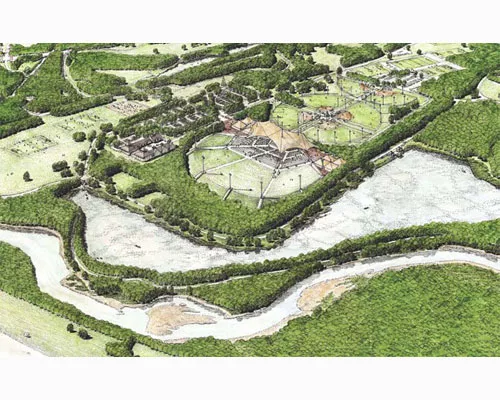
The vision includes riverfront development such as shopping areas and an enlargement of an existing park that will make it bigger than New York City’s Central Park, Frossard says. However, the entire plan is centered on flood control aspects, specifically the introduction of a huge bypass channel that will allow for development in the Uptown portion of the project.
The 1.2-mi long, 300-ft wide bypass channel will feature concrete walls on the east side and a dirt levee system on the west, anywhere from 25-35 ft. tall, says Saji Alummuttil, corps project manager. The channel will also feature some hydraulic lift gates at its start, middle and end, as well as a dam about .5 mi north of the bypass.
The corps is still in preliminary design for the gates, Alummuttil says, but has conducted hydraulic modeling in conjunction with the corps’ Sacramento District at Northwest Hydraulic Consultants, North Vancouver, British Columbia. “It took us a year to build and run the hydraulic model in Vancouver,” Alummuttil says. “We built the channel out of wood and concrete on a 1:40 scale in a football field-size building. We ran the water through to validate the data, converted to numerical and computer [data] and brought it back to Fort Worth.”
The Trinity River Vision project will also include three vehicular bridges and three pedestrian bridges that will cross the bypass channel. Those contracts will be handled by the Texas Dept. of Transportation. “The schedule has us starting bridge construction October 2011 and staggering the contracts by 18 months,” Frossard says. “It will be interesting because crews will be building bridges over dry ground, which will be less risky for contractors.”
The corps will begin awarding contracts for bypass wall construction within the second bridge contract time frame, Frossard says. Bypass walls will be a U-shape, avoiding the I-wall construction that failed in New Orleans, Alummuttil says. “All civil works projects across the nation are taking advantage of design lessons learned from Hurricanes Katrina and Rita.”
Before bypass construction begins, it is necessary to create storage areas to contain and reduce the anticipated increased velocity on cities downstream, Frossard says. “We have to build in storage for water so the net impact downstream is not changed.” Part of the vision includes four major locations of valley storage sites both upstream and downstream of the bypass channel. “We’ll be excavating bowls so that we can come back and create wetlands,” Frossard says. “We will be building rock weirs that will provide a series of ripples and pools that will create habitats, plant 60,000-80,000 trees in that zone and put in trails.”
One such storage area has already been completed, and The Penna Group LLC of Fort Worth received the notice to proceed in late March on another valley storage site. Interested contractors can sign up with the vendor database at www.trinityrivervision.org under “contracting” to receive notification on any upcoming bids, says Shanna Cate, planning and development manager. “Additionally, we send out invitations to workshops about what will be coming up in the next six months, how to get certified, bonding, things like that.” Two such workshops will be scheduled this summer, she says. “The database is also a good networking tool, so contractors can search for other firms they may partner with,” Cate adds.
The Trinity River Vision project is funded by the corps, the Federal Highway Administration, TxDOT, commitments from local partners, and a local tax increment.
-04_ENRready.webp?height=200&t=1668199635&width=200 "RFK Bridge Connector Ramp K to Northbound Harlem River Drive (RK-23C)")


