Vermont Dam Removal Program Reclaims Floodplain
Crews removed a century-old West Rutland, Vt. dam to prevent flooding
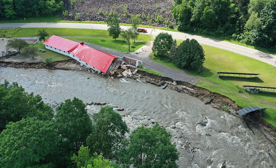
The July 2023 Great Vermont Floods destroyed scores of buildings, including the Inn by the River in Hardwick. The town, which received federal funds to buy the property and demolish the building, plans to reclaim the river’s floodplain.
Following a week of tree and vegetation clearing, crews of four to seven workers recently finished demolishing concrete at the top of a large century-old dam in West Rutland, Vt. to prevent future flooding and restore the watershed’s ecological resilience along Youngs Brook tributary.
Removing most of the 250-ft-long by 40-ft-high Young’s Brook Dam’s concrete and the excess soil reestablished “the channel for the dam’s brook as if the dam was never there,” says Ron Fabian, president of the project’s excavating subcontractor, Fabian Earth Moving.
RELATED
Massachusetts and Vermont Partner to Bolster Transportation Resilience
Prioritized by the Vermont Dam Task Force and the Vermont Dam Removal Initiative, which seek to raise awareness, identify derelict dams, and collaborate with communities and organizations at the watershed scale, the project is among the 80 dams physically removed in the state as of October 2025, including eight dams removed this summer, says Karina Dailey, a Vermont Natural Resources Council restoration ecologist and project manager overseeing the Youngs Brook project who also serves as chair of the Vermont Dam Task Force, which prioritizes projects for dam removal.
After suffering historic flooding in 2023, Vermont has removed more dams per capita than any other state, according to the environmental nonprofit American Rivers, and also enacted its 2024 Flood Safety Act, a first-in-the-nation law giving the state jurisdiction over twenty-three thousand miles of streams and rivers effective in 2028.
Dailey estimates five dams will be removed in 2026 with environmental partner groups adding another four more. “But this work is dynamic so it’s all forecasting,” she says.
Funded by congressional appropriations and administered by the Federal Emergency Management Agency along with state agencies, the Young’s Brook Dam is “a great example of a derelict dam no longer serving a useful purpose,” says Dailey.
.jpg "concrete dam remnants")
In September, crews from Fabian Excavation removed concrete dam remnants and sediment from the Young’s Brook Dam face in West Rutland, Vt.
Photo courtesy of Vermont Natural Resources Council
Reclaiming Floodplains
Removing the Young’s Brook Dam—the source of safety and flooding hazards for decades—could restore more than half an acre of flood plain. Mary Ann Goulette, West Rutland’s town manager, says the dam’s “removal not only reduces risk to homes, businesses, and infrastructure downstream, but also restores a natural river system that will serve us far better in the face of increasingly severe storms.”
In that spirit, the Flood Safety Act will authorize the state to preclude development within the river corridor for dams removed from a stream site with a drainage area greater than two square miles helping to “manage stream and floodplain processes toward a more natural equilibrium state,” says Mike Kline, a member of the Vermont Dam Task Force who spearheaded the act after retiring from a 30-year career in the Vermont Dept. of Environmental Conservation.
Kline says dams can disrupt natural sediment transport processes in streams, leading to more sediment deposition in some places and greater erosion in others. Removing dams with impoundments allows for the creation of “floodplains that function to store floodwaters and promote greater equilibrium between erosion and deposition, thereby reducing fluvial erosion during flood events,” he says.
.jpg "Old water control gate infrastructure")
Old water control gate infrastructure was preserved during concrete removal at the Youngs Brook Dam.
Photo courtesy of Vermont Natural Resources Council
River Excavation
The more than $626,000 Young’s Brook Dam’s removal project was originally required to finish by Oct. 1 to protect aquatic species that use the river through the fall, but received a two-week extension due to “the long wait from FEMA for funding approval to proceed” and due to the 11,000 cu yds of sediment in the impoundment required to be removed to shape the 850 linear ft of stream channel and address Vermont’s stream alteration permit requirements,” Dailey says.
The project involving river excavation began in August, following more than a month-long delay in receiving federal approval. The project finished Oct. 15 after project planning, design and permitting, completed in 2023, took about five years, says Jessica Clark Louisos, principal water resources engineer for SLR Consulting, the project’s onsite engineer and designer.
Louisos says removing such a large dam requires preplanning and implementing the project in stages to control the water and any potential sediment movement. “Water at any given moment in the project can change direction,” she says.
As of Sept. 30, the dam’s remaining concrete was located along the lowest point of bedrock with the top of the concrete at 804 ft elevation, level with bedrock on either side, notes an SLR Consulting report. A dam outlet pipe was also identified at 800 ft. Fabian’s crews also removed impounded sediment and graded the upstream channel.
Louisos credited the third-generation excavating subcontractor’s “skill and experience” in earth moving and concrete demolition in the area for the complex project’s success. She said the 88-year-old business “has worked on many river projects and understands the context of the river.”

The recent removal of the Young’s Brook Dam in West Rutland, Vt. created a bypass channel settling basin to help reclaim the floodplain.
Photo courtesy of Vermont Natural Resources Council
Weather Tracking
Dismantling a dam creates a channel that resembles a natural river for water to flow, says Louisos, who notes that “thinking through all the steps to transition from the river being on top of and behind a dam to a natural channel can require thinking about weather, which can change pretty quickly.”
The SLR team and the contractor are required to watch the weather and have agreed that if rain is expected, they must “button up or stabilize the site,” she adds. If the project is close to final grade in some areas, the work could include final stabilization, including putting down seed and mulch or adding additional erosion controls like self-fencing or hay bales. If water flows through the project via a temporary culvert, an additional pump may be necessary.
The dam was originally built as a West Rutland water supply, but it became obsolete when replaced by a more modern water supply system in the 1980s, says a VNRC press release.
In 2008, Russ and Ellen Green bought the property where the dam is situated. Three years later, the couple says, flooding caused by Hurricane Irene created a “mini–Niagara Falls that carved a huge new riverbend below the dam,” downing trees, altering the stream flow into the reservoir and filling the pond with sediment that harmed its aquatic life. “We are interested to see the transformation over the next several years as the new stream channel creates itself and the shrubs, trees and wildlife come back,” says Russ Green.


