West Virginia’s Watershed Project Wends Forward
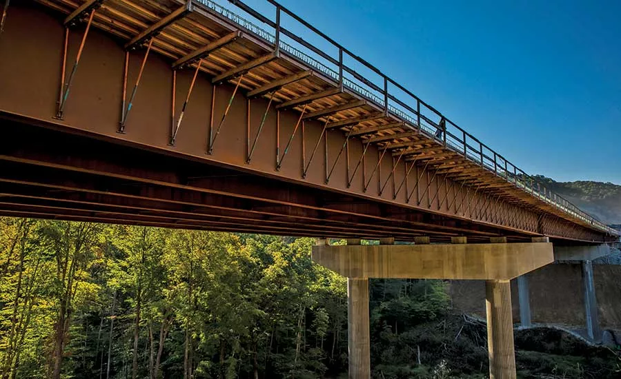
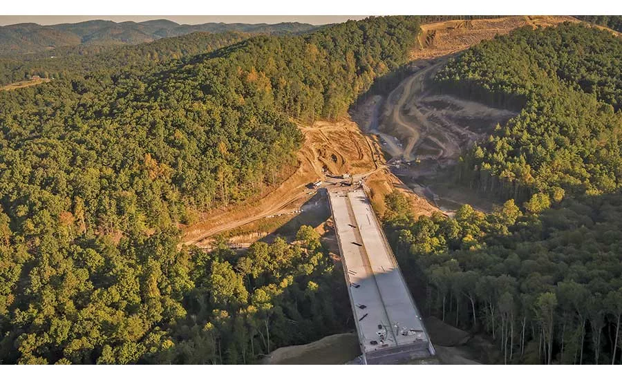
The first bridge built in the latest phase of the Corridor H project, one of the six major structures on the project, is 120 ft high and spans approximately 570 ft.
PHOTO BY HARRY GIGLIO FOR MICHAEL BAKER INTERNATIONAL
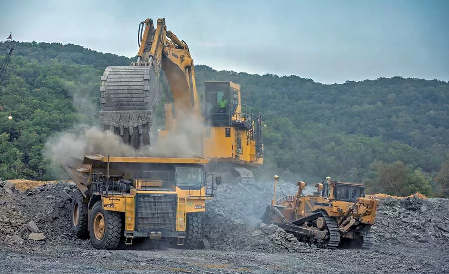
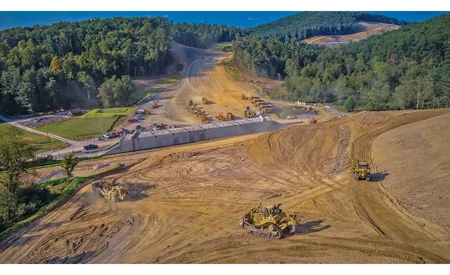
A recently completed 7.5-mile-long portion of the project included almost 12 million cu yd of excavation, while a 4.5-mile portion getting underway will excavate 10 million cu yd.
PHOTO BY HARRY GIGLIO FOR MICHAEL BAKER INTERNATIONAL
State transportation officials have worked with environmental and cultural heritage groups, the state Dept. of Environmental Protection, Army Corps of Engineers, Smithsonian Institution and U.S. Forest Service.
PHOTO BY HARRY GIGLIO FOR MICHAEL BAKER INTERNATIONAL
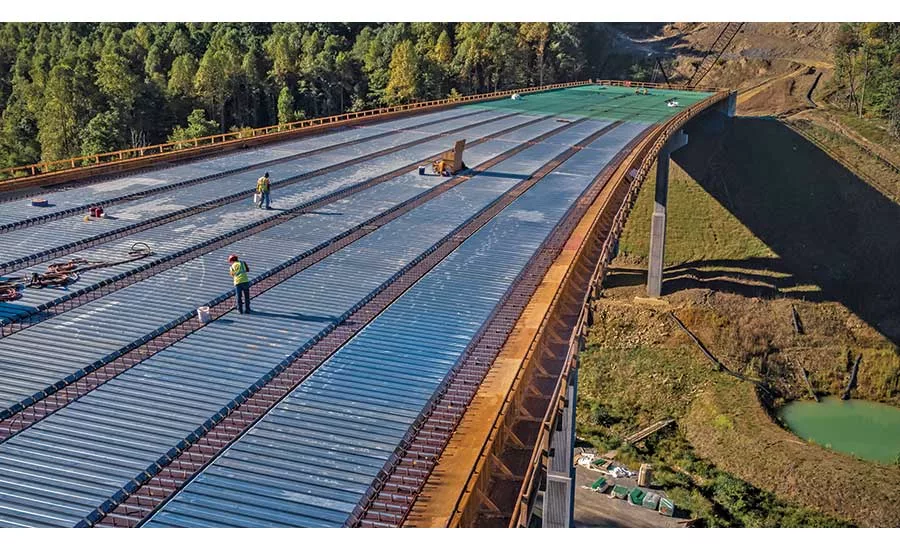
Work on one half of a 15-mile section includes 16 million lb of structural steel, 30,000 cu yd of concrete and 24,000 linear ft of piling.
PHOTO BY HARRY GIGLIO FOR MICHAEL BAKER INTERNATIONAL
A tunnel that was constructed to carry County Route 3 under the new roadway is approximately 230 ft long.
PHOTO BY HARRY GIGLIO FOR MICHAEL BAKER INTERNATIONAL
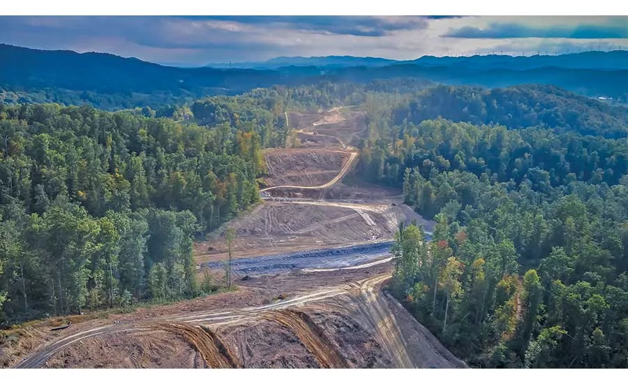
Corridor H looking easterly into the wilderness.
PHOTO BY HARRY GIGLIO FOR MICHAEL BAKER INTERNATIONAL
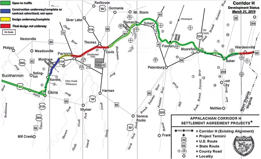
The 123-mile, four-lane highway taking shape through a national forest will, when complete, connect rural and largely isolated areas to key markets, including Washington D.C.
MAP COURTESY OF WEST VIRGINIA DEPT. OF TRANSPORTATION, DIVISION OF HIGHWAYS
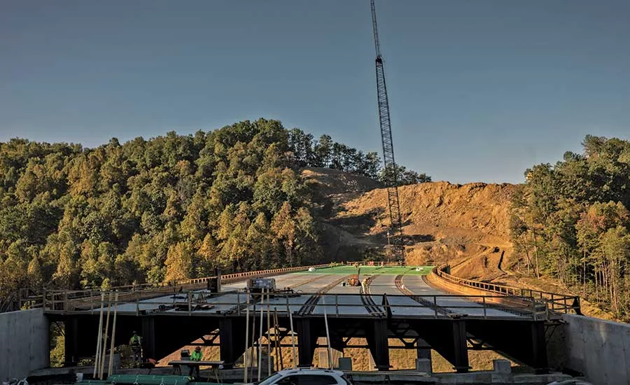
Design is beginning on a 6.8-mile section of the highway in Hardy County that will connect Wardenvilles to the Virginia state line.
PHOTO BY HARRY GIGLIO FOR MICHAEL BAKER INTERNATIONAL
A half century in the making, a 123-mile, four-lane highway is taking shape through a national forest and the rugged Appalachians. Corridor H, also known as U.S. Route 48, will, when complete, connect rural and largely isolated areas to key markets, including Washington D.C.
The 15.3-mile, $1-billion section currently under construction, linking the unincorporated West Virginia community of Kerens and the city of Parsons, is the largest-ever design-build project for the West Virginia Dept. of Transportation, Division of Highways (WVDOH).
The corridor, cited by Gov. Jim Justice (R) as the top construction priority for the state, is a product of the 1965 Appalachian Regional Development Act. When completed, Corridor H will be the only limited-access highway through West Virginia’s Appalachian Highlands region to Interstate 81 in Virginia.
Corridor H’s first 40 miles were completed in the 1980s. Michael Baker International began working with the WVDOH in the 1990s as program manager, says Mohiuddin Shaik, program manager with MBI. Kokosing, based in Westerville, Ohio, has the design-build contracts for the first half of the 15.3-mile section, released in 2015, and the second half, bid last year; the total contract value is $392 million. E.L Robinson, based in Charleston, W.Va, is the lead designer.
“The first project is 7.5 miles long and includes almost 12 million cubic yards of excavation, five large bridge structures and all of the associated drainage work,” says Andy Rhodes, Kokosing area manager. The second project, which is just starting, is 4.5 miles long and includes 10 million cu yd of excavation, three large bridge structures and all of the associated drainage work, he adds.
The alignment runs through the Monongahela National Forest and deep valleys, home to federally listed threatened and endangered species that require special consideration, says Shaik. “It is a breathtaking landscape. Our aim is to celebrate and preserve the beauty while connecting remote communities.”
Environmental concerns prompted a citizens group to file a lawsuit in the mid-1990s in response to the Federal Highway Administration’s Record of Decision approving the overall corridor. A court battle continued through 1999, when a compromise was struck. The parties agreed that the highway would be divided into nine segments, each requiring its own environmental process.
Since then, the WVDOH has worked extensively with environmental and cultural heritage groups, as well as the state Dept. of Environmental Protection, Army Corps of Engineers, Smithsonian Institution and U.S. Forest Service, to ensure harmony. “It’s opened my eyes as to how we’ve evolved in the environmental process,” says Dee Begley, engineer with the WVDOH’s alternative project delivery office. “It’s an experience unlike any other. We’ve met with the Forest Service and a lot of outside agencies. There’s never a dull moment.”
Extensive studies and tests had to be carried out to assure stakeholders that one plant in particular, the whorled pogonia, would not be adversely affected by the new highway, notes Shaik. “The alignment had to be shifted a couple of times,” he says. The team used 3D shadow modeling to make sure the sun continued to shine on the whorled pogonia despite the construction of eight steel bridges that range from 560 ft to 1,200 ft in length and are up to 230 ft high.
The agency must also monitor streams for up to five years after construction ends, adds Shaik. Moreover, he says, “These species studies expire every two to three years. We have to be aware of these deadlines. As we began procuring each section, we kept track of all these issues.”
On the entire Corridor H, WVDOH identified over 750 acres of wetlands. It has worked with various agencies to designate and protect large, high-value wetlands; according to the agency, only 37 acres of low-value wetlands will be used during highway construction. The mitigation process is completed in each design section of each construction contract for the corridor. About a dozen environmental agencies review and comment on the proposed mitigation plans and participate in field views as the plans develop.
In addition, the WVDOH uses a full-time environmental monitor who reports monthly to the agency, ensuring that contractors are properly constructing, installing and maintaining required mitigation measures and erosion and sedimentation control measures.
Although the design-build process, unfamiliar to many stakeholders, initially proved challenging, it ultimately was vital, says John Barger, the Forest Service’s liaison to WVDOT. “Trying to front-load the contract with [environmental] needs before the final design was tricky,” he says. “In the early stages, management personnel of the agencies all realized a designated liaison was needed.”
Barger met with various groups representing recreation, wildlife, timber, engineering, soil, water, minerals and other interests. Another challenge was conveying civil engineering details to non-engineers, he notes.
Although there are bobcats, bears, snakes and many deer in the area, “there are no significant wildlife issues,” Shaik says.
The area is “very steep and rugged, with lush vegetation,” Barger notes. “It’s tough terrain to build a highway in.” The second half of the 15 miles will include trout streams and require strict slope erosion control, he says.
Crews use temporary structures to span several streams to gain access to some sections, says Tony Sharkins, Kokosing project manager. “Most of the project work areas are accessed using only a few two-lane or smaller roads that snake their way through the mountains,” he says. “This has made it difficult to move equipment on the project and to deliver large steel girders to the bridge locations.”
Working through a construction season limited by weather, the crews are performing earthwork with a maximum cut of 180 ft high and 320 ft wide, and a fill as high as 170 ft and as much as 110 ft wide, project officials say. “We have up to six different earthwork crews to construct the projects, with the largest crew utilizing PC2000 excavators and 100-ton, off-road rock trucks,” says Sharkins. “Four bridge crews are being utilized along with many other support operations.”
The work on the first half of the 15 miles includes 40,000 linear ft of pipe, 450 acres of clearing, 6 million lb of rebar, 16 million lb of structural steel, 30,000 cu yd of concrete and 24,000 linear ft of piling, according to Kokosing.
Crews are also building a 24-mile hiking trail as part of the WVDOH’s environmental commitment, with a small equestrian bridge that will connect trails on either side of the new highway for hikers and horses at a trailhead.
“In addition, there are four structures located offline of the two project alignments in remote areas,” Rhodes says. “They will reconnect streams and improve aquatic organism passage in the surrounding regional streams.”
The contractor team has also used drone footage to inspect construction. “They did modeling to demonstrate early on how it would look and convince stakeholders for changes to waste sites,” says Shaik.
The transportation agency and MBI are drawing on lessons learned on the project’s first half to the second half, says Shaik. “We are executing a design-build project using design-bid-build documents” because that’s what the agency had, he notes. “[MBI] drafted a document to help the department of highways navigate requirements of our construction program management reviews,” he adds. The agency is working on an official design-build manual for future projects.
The design for the first eight miles is complete; design for the second half began in spring of last year and is continuing, Shaik says. The first 7.5 miles are scheduled to be completed by the end of next year, with the second half to be finished by 2023.
Appalachian Ambitions
At ENR press time, the WVDOH was about to receive expressions of interest from contractors for the next piece of construction—a nearly mile-long, 165-ft-high bridge over Cheat River, Shaik says. It will be the department’s first best-value design-build contract. The bridge will be located on a “wide, flat floodplain, with archeological resources to be avoided,” he says.
The U.S. Dept. of Transportation also announced a $12-million federal grant for the project this summer. That completed funding for the section from I-79 to the Virginia state line.
A couple of sections remain to be built. Design is beginning on a 6.8-mile section of Corridor H in Hardy County connecting Wardensville to the Virginia state line. Construction tentatively is scheduled to begin in 2027. Another section is a 10-mile area between Parsons and Davis in Tucker County. Final design of this segment is anticipated to begin in 2025. Construction tentatively is scheduled to begin in 2031, according to the WVDOH.
Although West Virginia is a hot spot for COVID-19, project officials say that the pandemic has not affected construction and that safety protocols are in place. One worker tested positive for the virus and returned to the jobsite after quarantining for two weeks and testing negative.
The project has received about $145 million in federal funding during the last 18 months, according to Rob Morris, president of the Corridor H Authority. In West Virginia, every other corridor designated under the Appalachian Development Highway Act has been completed, according to the authority.
When the highway opens, billions of dollars of exported goods from West Virginia will have direct access to the large inland port at Front Royal, Va.—where double-stacked containers move by rail to Norfolk, Va., the deepest port on the Eastern Seaboard. It will be eastern West Virginia’s only direct access to a global port, according to the authority.
“The first 40 miles take you to Elkins, which has seen the economic benefits of access from the D.C. area,” Shaik says. “That’s on the west end. On the east end, the town of Mooreville has also seen benefits. Right now Kerns is a small town not far from Elkins. Parsons is a small community, and the project right now ends northeast of it.”
The project’s goals also include improving highway safety. At present, to travel from Elkins through Thomas and Scherr to Moorefield, and from there to the Virginia border, motorists must drive more than 119 miles along U.S. Route 219 and West Virginia routes 93, 42 and 55, according to the WVDOH.
The new highway will trim almost 20 miles from the total distance between Elkins and the state border, the department calculates. The highway also can serve as an evacuation route, if needed. When the new four-lane highway is open, the corridor is expected to attract more motorists and ecotourism to a remote and beautiful part of West Virginia. Shaik says, “It’s like driving through a Monet painting.”


