Flooding Damage From Massive Winter Storm in Massachusetts Will Take Weeks to Assess
Frigid temperatures will complicate cleanup and damage assessment efforts
A massive snowstorm dubbed the “bomb cyclone” broke Boston’s record for its highest tide ever recorded by the National Weather Service, but fully assessing the storm's damage will take weeks in a region that was plunged into frigid temperatures the day after the Jan. 4 storm.
“It always takes a little bit of time, people have to assess the problem areas,” says Wayne Cobleigh, a vice president at engineering firm GZA, who coauthored a paper in August on financing resiliency projects in Connecticut. “That’s going to be complicated by the extreme temperatures, the extreme cold we are going to get today and tomorrow. People that had imminent impacts are already out there today trying to figure out how to get reimbursed and make insurance claims.”
The tide reached 15.16 ft in Boston, beating the old record (15.1 ft) set during the infamous Blizzard of 1978. The storm surge, along with record snowfall and winds as high as 76 miles an hour, turned some Boston streets into ice-cold rivers. Aquarium Station on the MBTA’s Blue Line was closed after it flooded. Significant flooding was seen up and down the coast too, including in Scituate after a seawall failed.
And with Boston projected to experience between 2 ft and 6 ft of sea-level rise by the end of the century, Mayor Marty Walsh said at a news conference that the storm is a reminder of what's to come. “If this wasn’t snow, if this was rain, we’d have additional flooding,” he said. “We have to pay more attention to what we’re doing with climate resiliency.”
But while images of flooded city streets that made the rounds on social media might have shocked some, they didn’t surprise the engineers who study floodplain maps, coastal erosion and sea-level rise. “This is classic nor’easter and this is what nor’easter's do,” Cobleigh says. “People think a winter storm is just snowfall but you have to understand wind, waves and surge cause flood damage.”
Some of the worst flooding was in Boston’s Seaport district, which has been the posterchild for the city’s building boom in recent years. Flood water had receded enough the day after the storm to allow some of the construction sites in the neighborhood to resume work. Projects in the Seaport have also already incorporated resilient designs such as putting mechanical systems on the roof to protect them from floods. Those measures are partially a result of the Federal Emergency Management Agency revising its flood plain map in 2016. Last October, the city’s “Climate Resiliency - Review Policy Update” was also approved, which among other things, requires developers to account for seal-level rise.
Aaron Lewis, a principal at Simpson Gumpertz & Heger, says owners will likely be encouraged to take even more flood precautions now that they’ve seen with their own eyes the kind of flooding that can happen in coastal areas. But Lewis says determining how, when and what kind of flood barriers to deploy during a storm is complicated, especially during nor’easters that tend to be longer events than hurricanes.
“It’s going to be a big challenge for engineers, owners and advisors of big complexes,” Lewis says. “It’s not like you just flip a switch [to deploy the barriers]. All those details need to be thought out.”
The storm also renewed calls for a $10 billion sea barrier in the Boston Harbor. The University of Massachusetts Boston currently is studying the feasibility of the 4-mile-long barrier that would enclose the harbor.
Dan Stapleton, a senior vice president and senior principal at GZA, has been asked to peer review UMass Boston’s barrier study after it is completed later this year. Stapleton says building the barrier will be complicated by the combination of potential environmental, permitting and funding issues. “It’s a feasible idea but there’s a lot of challenges,” Stapleton says.
Stapleton says neighborhood and municipal-scale projects are “more likely to be implemented,” similar to the approach taken in New York and New Jersey after Hurricane Sandy. In fact, the “Climate-Ready Boston” study takes a regional approach to sea-level rise by collaborating with the Massachusetts Office of Coastal Zone Management. The plan also deploys neighborhood-level solutions as well.
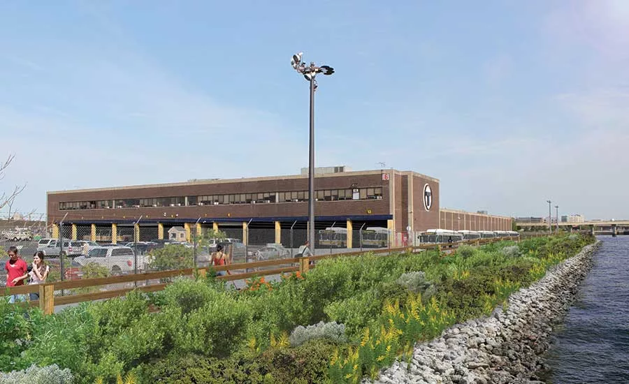
Meanwhile, other projects in the area don't call for walling off the water at all. A bike and boat rental area on the ground floor of a condo building being constructed on the Boston Harbor in East Boston is designed to be floodable. And Instead of rebuilding a deteriorating seawall in front of its largest bus maintenance facility in Charlestown, the MBTA is constructing a $34-million embankment to buttress the existing wall. Landscaping above the high-water elevation will create a “living shoreline,” providing a more natural, gradual and resilient sea barrier than a sharp bulkhead.
Paul Schuman, a senior staffer for the project’s lead engineering firm, SGH, says the project site wasn’t significantly damaged by the Jan. 4 storm. “Tides and water reached the very top crest of shoreline but didn’t overtop it,” says Schuman, who noted that some of the shoreline could be lost to erosion due to the storm.
The Massachusetts Emergency Management Agency will conduct initial damage assessments during the next several weeks, a spokesman for the agency says.


