NYC Unveils New Waterfront Plan
New York City’s Waterways could see nearly $3 billion in improvements under a plan released by city officials in March.
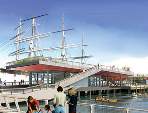
The Waterfront Vision and Enhancement Strategy, led by the Dept. of City Planning, represents the first citywide plan for the waterfront in almost two decades and aims to reconnect New Yorkers with the waterfront.
The first of two components includes 130 funded projects that could create an estimated 13,000 construction jobs and 3,400 permanent jobs, according to city officials. Plans call for development of more than 50 acres of new waterfront parks, the creation of 14 new waterfront esplanades and a new East River ferry service between Brooklyn, Queens and Manhattan.
The second component, called Vision 2020, is the first-ever comprehensive plan for the city’s waterways, providing a blueprint of its 520 miles of shoreline. Water quality is a major component of the plan, which calls for $1.6 billion in wastewater treatment plant upgrades. The plan also outlines $650 million in gray infrastructure; $140 million to enhance drainage by acquiring land in Staten Island; $50 million in waterfront ecological restoration projects; and private investment of $150 million to facilitate 21 waterfront development projects.
“We’re committed to making [New York City’s waterways] a part of New Yorkers’ lives again for recreation, transportation, jobs and housing,” says Deputy Mayor Robert Steel.


