When Thomas Kaufmann, an engineering-plans design supervisor at the Philadelphia Dept. of Water, sends engineers out to the field to look for underground water pipes, he says they typically have to take more than 120 maps in the truck to help track down the pipes. Once at the location in question, the engineers must rifle through countless paper maps to locate the one correct subsurface-infrastructure map to proceed.
But after Kaufmann beta-tested Bentley's latest app, which shares free geospatial information, his team may say goodbye to paper maps. The test also is helping to drive tablet adoption in the utility's office.
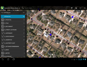
“Based on our beta-test of Map Mobile, we put in a purchase for Android devices,” says Kaufmann. Map Mobile, the latest release by Bentley Systems of Exton, Pa., is currently available for tablets and smart devices that run on Android operating systems. It lets users view Bentley Map’s geospatial data while in the field.
Map Mobile can download and store an i-model map for offline-mode access, viewable anywhere, even without a network connection, says Keith Raymond, product manager for Bentley. When connected to a network, Map Mobile can integrate with Google Maps to plot directions to features on the map.
That clients are asking for more apps to help them leverage geospatial information is a sign to Bentley that construction professionals are getting more sophisticated about leveraging geospatial data in the field. That wasn't always the case for Bentley, which has produced about 50 apps in the past few years to complement its products.
“We were doing the pushing, and they weren’t receiving,” says Raymond. But when a large utility with a wide service area asked Bentley to bring the geospatial information it already was providing into the hands of fieldworkers, it spurred Bentley to continue development.
“They [the users] came to us. They’re doing the pulling,” he says, adding that the development effort that has gone into creating the Map Mobile app should lay the foundation for rapid development of more apps in the future. “I believe [Map Mobile] will be the basis for our mobile products, for sure.”
Bentley has released to the public its underlying mobile graphics engine as a platform in the form of a software development kit (SDK). Imagination is now the only bar to external developers building on the SDK, which is available for free on Bentley’s developer network. Releases for iPad users are in the works.
“We plan to release an iOS version in the near future as well,” says Raymond. He says the company does not yet have a release date for an iOS version as it is feeling out demand.
However, Kaufmann says he is pleased the app premiered on the Android platform.
“ ‘iPad’ is a catchphrase now. There’s a certain stigma based on the name,” Kaufmann says. And for the Philadelphia Dept. of Water, it’s a stigma followed by a lot of zeros, he adds.
His department wouldn’t even have considered a request for iPads, Kaufmann says, but when he wrote his request for “tablets” to bring staff infrastructure geospatial data in the field, he got the green light.
Map Mobile runs on any Android device, but Raymond says it was developed for and looks best on a 10-in. Android Tablet. The app displays geospatial data from a Bentley Map user’s SQLite database in the form of Bentley’s mobile-friendly i-models. The data is displayed as information-packed features in the i-model map.


Post a comment to this article
Report Abusive Comment