
The results are in. Data from instruments installed within a big New Orleans levee has allowed the contractors to exceed ambitious schedule-compression goals. The team successfully employed a novel design based on miles of wick drains and geotextile fabrics. The system is achieving soil consolidation and strengthening faster than predicted.
“We're comparing theory to reality in performance,” says Richard Varuso, deputy chief of the U.S. Army Corps of Engineers' geotechnical branch in New Orleans. “Whenever you validate theory versus performance, the engineering community learns something.”
The amount of geotechnical data compiled from the levee reach known as LPV 109 already is informing the design of other projects, including plans to raise a 32-mile stretch of non-federal levees in Plaquemines Parish.
A conventionally built earthen levee comparable to LPV 109 would require a decade of incremental lift placements, separated by long pauses for natural soil compression. By using an elaborate wicking and drainage system rigged with instruments to report soil movement and consolidation within and below the structure, engineers fine-tuned the schedule with lead contractor Archer Western Contractors Ltd., Atlanta. They shaved work duration at sites along the 7.54-mile-long project to 45 to 60 days compared with the targeted 90 days.
“In reading the data from the instrumentation cluster, you're like a detective, looking for clues that converge,” says John Volk, URS Corp., San Francisco. Volk is lead geotechnical engineer on the project. “In areas where we realized strength had been achieved, we gave them the green light to add lifts sooner than the initial wait time. This was geotechnical engineering at its best,” Volk says.
The construction of LPV 109 in eastern New Orleans is part of the Corps' $14.6-billion program to bring the city's perimeter protections to 100-year levels by this year's hurricane season. URS developed plans and specifications to rapidly build the reach to heights varying from +18 ft to +25 ft and widths varying from 320 ft to 360 ft on soft, marshy soils.
The URS design called for three different types of geotextile fabrics totaling 1 million yd, a wick-layer sandwich of rock sand and fabric, and 9 million linear ft of wick drains stabbed up to 40 ft deep in varying configurations in response to wildly variant soil conditions. Construction also required 3.3 million cu yd of clay.
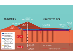
Validating design
To monitor new material placement, settlement plates were installed every 300 linear ft at +2 ft elevation along the front edge of the stability berm and under the center of the highest part of the levee.
In addition, crews installed 28 instrumentation clusters to monitor changes deep within and below the levee at intervals of 1,500 ft to 2,000 ft. Each cluster includes multipoint borehole extensometers—also known as spider magnetometers—to monitor consolidation of soil at multiple levels below the structure as well as inclinometers to detect horizontal shift and piezometers to measure hydraulic pressure below the heart of the levee.
The settlement plates are direct-read devices consisting of 30-in.-sq steel base plates with double-walled measuring tubes rising vertically. Volk says they are used to monitor clay placement during construction. During peak activity 20-ton dump trucks delivered 200 loads daily. “Settlement plates give you an overall global reading of how the whole levee is settling,” Volk says.
The spiders consist of magnetic rings with splayed arms slipped over a vertical tube installed deep in the soft soil below the levee. The bottom of the tube is anchored in a Pleistocene-era, non-compressing sand layer about 40 ft down. A pair of datum magnetic plates ring the tube in the sand layer at -52 ft and -49 ft elevation to provide a reference mark. As long as the plates are 3 ft apart there is no consolidation at that level.
The lowest spider magnet is placed at the interface between the sand and the 40 ft to 60 ft of soft clay soil under the levee, with four more spiders spaced 5 to 10 ft apart around the tube above it until they are within 6 ft to 10 ft of the base of the new construction.


Post a comment to this article
Report Abusive Comment