Researchers working with the National Aeronautics and Science Administration, with the help of twin satellites whose sole purpose was to collect data on the Earth’s water storage, have found dangerous groundwater loss in three northwestern states of India.
Scientists concluded that groundwater depletion is a direct result of irrigation and other human activities that keep groundwater from recharging at a sustainable rate.
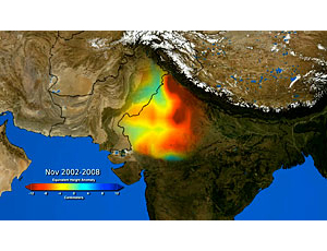
In six years of observation, from August 2002 to October 2008, NASA charted a steady depletion of an average loss rate of 1 meter in groundwater levels every three years in the region.
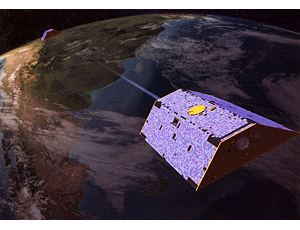
In their report, researchers explained that the satellite mission GRACE—Gravity Recovery and Climate Experiment—“measures temporal variations in the gravity field, which can be used to estimate changes in terrestrial water storage.” The pair of satellites orbit Earth in tandem, traveling approximately 220 kilometers apart at a 485-km altitude. They transmitted monthly measurements of India’s northwestern region back to Earth.
According to NASA, changes in underground water masses affect gravity enough to provide a signal, and changes in gravity can be translated into a measurement of an equivalent change in water.
Researchers Matthew Rodell, James Familgietti and Isabella Velicogna say GRACE can detect water at all levels, from which they were able to isolate and extract specific information signaling groundwater changes.The report was published in Nature magazine on Aug. 12.
“The mission has been extremely valuable for hydrologists. GRACE is the only satellite system able to monitor changes in water below the land surface,” Rodell says.
In examining the Indian states Rajasthan, Punjab and Haryana, NASA chose GRACE, launched in March 2002 by NASA and the German Aerospace Center, because the satellites can retrieve data that would be otherwise unavailable or obtained by potentially inaccurate well surveys. The team used 73 monthly reports generated by the Center for Space Research at the University of Texas at Austin.
Researchers factored in surface-water storage, effects of potential leakage from glaciers in the Himalayas 100 km away and soil-water storage but were able to conclude these variables in groundwater levels had little to no interference with water depletion. They also noted that while India as a whole experiences about 120 centimeters of precipitation per year, Rajasthan, Punjab and Haryana only see roughly only 50 cm of annual rainfall.
In the observation period, “the region lost 109 cu kilometers of groundwater, double the capacity of India’s largest reservoir, the Upper Wainganga, and almost triple the capacity of Lake Mead, the largest man-made reservoir in the U.S.,” researchers wrote. They predict severe potable water shortages, reduced agricultural activity and conflict will force the region’s residents to react.
The National Ground Water Association, Westerville, Ohio, has been following trends in groundwater depletion, such as in India, but its officials also see the need to make more efficient use of the resource.
“A key to addressing some of the water scarcity issues around the world, in addition to efficient use of water, is conjunctive use of water resources,” says Cliff Treyens, NGWA’s public awareness director. “And conjunctive use of water involves some construction strategies, such as aquifer storage and recovery.”
He points to the San Antonio (Texas) Water System, which uses an aquifer storage and recovery system. The Edwards aquifer stretches across 8,000 sq miles and 13 counties in south central Texas and has an average daily extraction of 136.5 million gallons.
In the U.S., NASA has already used the satellite mission to observe groundwater levels in the Mississippi River Basin and plans to apply GRACE for drought monitoring and water-resources assessments.
“We are also looking at other parts of the world where groundwater levels may be declining, including the Central Valley of California,” says Rodell.

Post a comment to this article
Report Abusive Comment