
A historic Boston transit hub is undergoing a high-tech examination in preparation for its future. Early-stage work on Boston's $850-million South Station expansion proposal is deploying a robust level of construction-sequence modeling in hopes of minimizing major construction conflicts within a rail hub that sees more than 100,000 daily commuters.
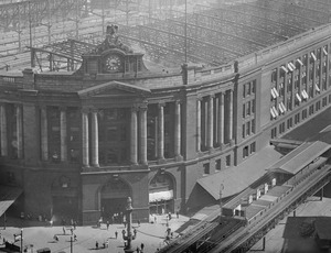
South Station, a 110-year-old architectural icon, is Boston's busiest multimodal transportation hub and the sixth-busiest hub for Amtrak, the national passenger railroad. Gov. Deval Patrick (D) recently made the South Station expansion a priority in his $13-billion transportation plan for the state. The project is currently in planning, environmental review and preliminary design.
According to the Massachusetts Dept. of Transportation, the expansion would improve on-time performance of Amtrak and local train and bus services.
When first constructed, South Station had 28 tracks to accommodate several independent railroad companies. But rail traffic declined after World War II, and the railroads left. The train station was partly demolished and all but deserted before the Massachusetts Bay Transportation Authority embarked on a major renovation in the 1980s. The MBTA transformed it into a multimodal hub with new tracks, a garage and a bus terminal (ENR 2/19/81 p. 20).
Now, MassDOT says, the alternative analysis aims to determine how best to create a new layover facility, plan for the relocation of an existing U.S. Postal Service facility to make room for expansion and consider opportunities for joint public-private development related to the expansion.
MassDOT's project management consultant team is using a plethora of software tools, including Legion for passenger and egress modeling; authoring tool Revit; LiDAR for spatial data gathering; 3D Studio Max for visualization; Bentley RailTrack for rail infrastructure design; Dash Port—an HNTB proprietary program for project management—ProjectWise for information management; Primavera P6 for scheduling; MathCAD for catenary sag analysis; and Tredis for transportation impact analysis.
Mike McInnes, project manager with HNTB, says the team plans to use Syncro software for analysis and design of systems to accommodate multiple modes of transportation and street alterations.
Berkeley Rail Traffic Controller simulation software is being used to model traffic loads and run what-if scenarios. "This is helpful in planning a multiphase construction project where you might need to see the ripple effects of changes in availability of tracks and other resources throughout the construction schedule," says Kristine Wickham, deputy project manager with Vanesse Hagen Brustlin (VHB), a member of the project team that also includes HNTB and Arcadis, among others. "The team will develop several modeling scenarios to test the various construction phases and different infrastructure elements that are proposed."
The simulation model will allow MassDOT to test various operating plans to support interim operations during construction. The model also will help the agency to identify associated costs, including for temporary infrastructure.
Moreover, the South Station is located on the north end of Amtrak's Northeast Corridor. "There are lots of plans for service increases along that corridor," Wickham says. "We are looking at the big picture and how we fit into other planning efforts."


Post a comment to this article
Report Abusive Comment