As the Hurricane Irma forecast comes into tighter focus, U.S. Army Corps of Engineers officials warned on Sept. 8 that there may be increased risk for localized flooding caused by overtopping at several construction sites along the Herbert Hoover Dike around south Florida's Lake Okeechobee.
"We now believe we will see significant overwash and limited-to-moderate overtopping at three specific culvert construction sites" along the 143-mile-long dike perimeter, says Col. Jason Kirk, the Corps Jacksonville District commander. "Should we have this overtopping scenario, we expect to see water coming over the top of the coffer dam which would aggravate any localized flooding. The potential impacts of this scenario we’ve shared with emergency management at the state and local level."
The updated information provided at a Sept. 8 press conference was based on a National Weather Service forecast that now calls for Category 4-force winds at Lake Okeechobee and between 10 and 15 in. of rain. Hurricane force winds can be expected to impact the lake for up to seven hours under the revised forecast.
Earlier this week, the Corps had begun a pre-storm drawdown of impoundments that includes water releases from Lake Okeechobee, a 730-sq-mile lake with an average depth of 9 ft that is estimated to contain about one cubic mile of water, at normal levels.
Despite the water releases, lake levels actually rose slightly over the past two days due to the area's usual rainfall. Despite this, "the lake is starting at what we consider a favorable elevation as the storm approaches," says Corps dam safety officer Laureen Borochaner. "Our normal operation is 12.5 to 15.5 ft, and we are currently at 13.7 ft, so that puts us in a good position as this storm comes down upon us."
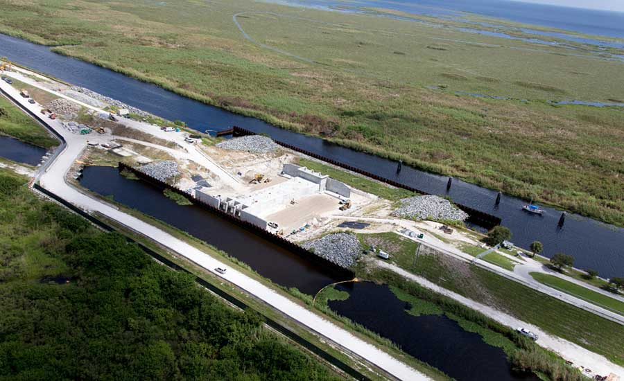
While the Herbert Hoover Dike was built to a lakeside elevation of 35 ft, the coffer dams at the three construction sites at risk range between 23 ft and 27 ft high. The lower height of the temporary structures is a balancing act between the relatively short duration of construction, between 18 and 24 months, and the cost of engineering and construction of the cofferdams, Kirk says.
The cofferdams at risk of overtopping include the Harney Pond site near Lakeport in Glades County, the culvert 2 site in Hendry County near Clewiston, and the C12 site in Palm Beach County south of Pahokee.
If the current forecast pans out, the lake could rise about 1 ft, but would remain within normal operating levels and well below the lake's record 18.77-ft-level pool. "We are in a low-risk condition for a breach scenario," Kirk says.
The work at Clewiston involves replacement of a water control structure. It is one of 26 being overhauled in an upgrade program.
“It’s fairly far along," said Borochaner. "The water-control structure is complete but backfill has just commenced. It’s an open excavation in the dike with a cofferdam, and because it is open and ongoing, we are monitoring it as an area of higher risk."
Hurricanes in 1926 and 1928 led to catastrophic flooding from wind-driven storm surge that overtopped the mud dikes surrounding the lake at that time, and are estimated to have killed about 2,500 people.
Subsequent hurricanes and wind-driven surges—and even over-toppings—have been managed through Corps of Engineers' improvements to the system’s channels, gates and levees.
After the storm passes, the gates can resume operations once the wind drops below 40 mph, said Borochaner. Drainage through the watershed of a foot of rain in the area, should the storm hit and deliver that, could push the lake level up as much as 3 ft over the next three to four weeks, she said.
Agencies, Contractors Prepare
With time running out before Irma's anticipated Sunday morning landfall, Florida's transportation department and regional contractors are scrambling to remove construction equipment, barricades and other potential wind-driven projectiles from hundreds of jobsites.
Lanes closed for construction are also being reopened wherever possible to accommodate an expected surge of traffic, as residents escape a storm that has already demonstrated its destructive power on islands in the Caribbean. Shoulders along key evacuation routes are also being readied to provide additional emergency capacity.
The Sept. 8 updated forecast significantly raised the threat of significant storm surge along the west coast of Florida, with up to 12 ft called for in Lee County, especially between Captiva and Chokoloskee. In a Friday press briefing, Gov. Rick Scott pleaded with residents to immediately follow evacuation orders. With the surge potentially cresting higher than the tops of some single-family homes, "you are not going to survive this if it happens," he warned.
Manatee County officials plan to temporarily open the nearly complete Fort Hamer Bridge near Bradenton to traffic over the weekend, providing residents and first responders with a reliable alternative to existing flood-prone routes.
According to a project spokesperson, the 2,300-ft-long, $23.5-million bridge being constructed by Johnson Brothers Corp. has mainly punchlist items remaining, with temporary pavement markings applied to safely convey traffic. Plans call for the bridge to be closed for work to resume on Sept. 12, with the only schedule impact expected to be the potential addition of weather days.
As more drivers are relying on GPS navigation tools, the Florida DOT is working with Google to implement real-time Google Map “closures” of roads that may disrupted or taken out of service by the storm.
Miami International Airport announced plans to remain open throughout Irma, closing only if “severe damage or safety concerns” force evacuation of stranded passengers and non-essential airport employees.
Orlando International Airport announced plans to close on Sept. 9, in the afternoon.
Further north, transportation officials in Georgia and South Carolina are taking similar steps to accommodate evacuation traffic, and prepare for Irma’s possible arrival.
The South Carolina Dept. of Transportation on Sept. 7 notified contractors to discontinue lane closures for non-emergency highway work on all interstate highways. Agency crews are clearing drainage systems for major roadways in low-lying areas to reduce the potential of flooding, and staging generators to support traffic management centers and other critical facilities.
In a statement, SCDOT Deputy Secretary for Engineering Leland Colvin called the actions “normal processes we would begin should any emergency arise.”
With memories of 2015’s massive flooding still fresh, the state Department of Health and Environmental Control has advised owners and operators of reservoirs statewide to check their dams and take appropriate steps to safely lower water levels for what could be another major rain event. Near the state capital of Columbia, South Carolina Electric and Gas has already begun releasing water from its Lake Murray reservoir.


Post a comment to this article
Report Abusive Comment