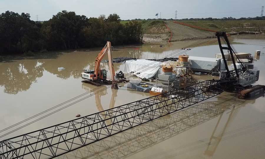
With water levels on a very slow decline in the Houston area, the U.S. Army Corps of Engineers Galveston District has begun reducing controlled releases at Addicks and Barker reservoirs.
Controlled releases began on Aug. 28 at about 800 cubic feet per second from each reservoir, steadily increasing to peak at approximately 7,000 cfs at both locations on Sept. 1. Pool levels at both structures peaked on Aug. 30, above 109 ft at Addicks and above 101 ft at Barker.
The evening of Sept. 3, “we began the gradual reduction of the outflows of the Addicks and Barker reservoirs into the Buffalo Bayou system,” says Col. Lars Zetterstrom, USACE’s Galveston District commander. “This will be a gradual process that will occur starting last evening where we were at around 13,000 cfs until we reduce down to approximately 4,000 cfs on or about September 15.”
"If we bring the water down too fast, there’s a potential for damage to our structures here, as well as damage to infrastructure and the Buffalo Bayou downstream."
– Richard Long, natural resource management specialist, US Army Corps Galveston District
Outflows must be reduced slowly, notes Richard Long, natural resource management specialist on the operations team for Addicks and Barker with the USACE Galveston District. “If we bring the water down too fast, there’s a potential for damage to our structures here, as well as damage to infrastructure and the Buffalo Bayou downstream,” he says. “We are reducing our releases at Barker first, and then at Addicks.”
As of Sept. 4, outflows at Barker were around 5,500 cfs, while Addicks was about 6,000 cfs, Long adds. Water releases are currently being done using water control manual guidelines, which were developed jointly between Corps and Harris County.
Slow reductions will also prevent potential damage to bridges downstream along Buffalo Bayou as well as the Bayou itself, while also minimizing risk to the water control structures that ultimately protect the city of Houston, Zetterstrom says.
“The gradual [reduction of] releases also help reduce stress on the outlet structures themselves. These structures, which allow the safe controlled release of the water from the reservoirs through the dams, are 70 years old. Although well maintained, we are currently in the process of replacing them with new outlet structures,” he adds.
Work is still in the early stages on these new outlet structures, and the flooding from Harvey has delayed their completion by an estimated six months at this point. That would place completion of the new structures at around mid-2020, according to Ralph E. Steiner, area engineer and administrative contracting officer for the new outlet structures.
“It was a tough decision [to begin making controlled releases], but it was one we had to make to ensure the integrity of the project,” explains Long. “As the reservoirs were filling up from the rainfall of Hurricane Harvey, we saw a rate of rise – water coming into the reservoir so fast – that if we did not begin these releases, we would have had water uncontrolled going around the ends of the dam, and that could have easily been two or three times as much as we are seeing right here going down into the subdivisions. So the decision was made to begin making these releases, knowing that it would flood some homes downstream, most of which we feel were already flooded by Hurricane Harvey itself.”
Lawsuit Against Flood Control District
Local residents and businesses have filed a lawsuit against the Harris County Flood Control District and the city of Houston related to the controlled release of water from Addicks and Barker reservoirs. Potts Law Firm, a Houston-based law firm, announced Sept. 5 that it filed a class action on Sept. 3, 2017. The plaintiffs allege their properties did not flood after Hurricane Harvey sat over Harris County on Saturday and Sunday, Aug. 26-27, but began flooding when the controlled releases began on Aug. 28. According to the announcement, the lawsuit seeks damages for the government's intentional taking of properties by flooding, recovery for property repair costs, diminution in value of the properties, lost income or business income to the properties' owners, and any consequential loss of the flooding.
Despite the controlled releases, approximately 4,500 cfs of water did flow around the north end of Addicks Dam—but that level could have been up to 30,000 to 40,000 cfs around the upstream ends of the dam had the Corps not decided to begin the higher 13,000 cfs releases through the outlet, Long says.
Maximum outflow release between the two dams is designed as high as 16,000 cfs, but following Hurricane Harvey, releases peaked at just above 13,000 cfs.
“This was an unexpected, unparalleled level event. Over 1 trillion gallons of water fell over the greater Houston area,” Zetterstrom says. “We have retained over 140 billion gallons of water at peak behind both reservoirs.”
Once the releases are down to 4,000 cfs, the flow at both reservoirs will be within the normal banks of the Buffalo Bayou. The previous peak outflow was 4,000 cfs—typically the Corps would only release at a rate of 2,000 cfs from the reservoirs during rainfall events, Zetterstrom notes.
Waiting for Waters to Subside
It could take up to about three months for the flood waters within the reservoirs to completely subside, assuming no major additional rainfall in the area, according to the Corps.
“If we experience another rainfall event before the reservoirs are empty, higher releases could become necessary again,” Zetterstrom says.
To determine solutions moving forward, the Corps had previously proposed and requested funding for two feasibility studies to examine the environmental changes around the Addicks and Barker reservoirs. The feasibility studies would help determine what alternatives should be developed, either to modify reservoirs to be able to provide increased flood risk management or just improve their operations, explains Zetterstrom.
One of the studies will examine Addicks and Barker reservoirs, while the second will be a region-wide watershed study to examine the whole Houston Metro area and how all the systems could work better together, Long says.
The Harris County Flood Control District, the Corps’ non-federal sponsor, has already signed letters-of-intent to jointly conduct these feasibility studies.
“Broadly, we’d be looking at ways that the outflows would not impact people downstream, such as canalize them. We could look at ways to balance the water levels in the structures, and look at additional capacity,” Zetterstrom says. “For instance, material could be borrowed from inside the reservoirs and that material could be used for construction or other purposes… possibility of some type of future dam and reservoir system upstream, maybe in the Cypress Creek watershed. That’s all conceptual. Right now we just have the letter of intent [for the study].”
Once these studies are funded, work should progress fairly quickly on both, Long says.


Post a comment to this article
Report Abusive Comment